Following the 2008 and 2009 excavations of the colonial-era redan at the east end of Tradd Street (now South Adger’s Wharf), the Mayor’s Walled City Task Force began planning with the City of Charleston to depict the outline of the redan’s foundation on the present landscape. After considering and dismissing several methods and materials for accomplishing this goal, Mayor Joseph P. Riley insisted that brick should be used in order to render the outline as visible and as durable as possible. Some months ago Charleston Museum’s archaeologist Martha Zierden used spray-paint to touch up the series of pink dots on the road surface that indicate the outline of the redan’s inner and outer faces. This morning workers used masonry saws to connect those dots, and removed the asphalt and cobblestones between the inscribed lines. In the coming days, we’ll see the finished effect–a handsome brick pathway that follows the precise outline of the redan’s walls, which remain standing just two feet below the modern surface. The public is invited to visit South Adger’s Wharf and view the new work. If you can’t make it down to the site, enjoy these photos taken by task force co-chair, Katherine Saunders Pemberton, earlier today. 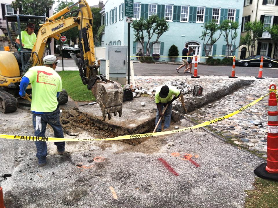

South Adger’s Wharf
20 May 2013
Redan Outlined in Brick
Posted by Nic Butler, Ph.D. under archaeology, Charleston, Charleston Museum, fortifications, history, South Adger's Wharf, Tradd Street RedanLeave a Comment
28 January 2013
Curtain Wall exposed!
Posted by Nic Butler, Ph.D. under archaeology, Charleston, history, South Adger's Wharf, Tradd Street Redan[3] Comments
Site of the dig on 23 January 2013
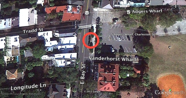
On Wednesday, January 23rd, a section of colonial Charleston’s waterfront “curtain line” or “wharf wall” was exposed, measured, and mapped for the first time. This happy event took place during a one-day dig sponsored by the Charleston Water System, a Task Force member who had recently conducted utility work in the vicinity, and generously offered to supply labor and equipment for a brief exploratory dig. The site chosen was a small patch of asphalt, grass, and concrete sidewalk on the east side of East Bay Street, just a few yards south of South Adgers Wharf. Excavations at that site in 2008 and 2009 revealed the remains of the redan or salient angle that once stood at the east end of Tradd Street, but neither of those digs extended sufficiently westward to locate the brick curtain line that tied into the redan.

Looking northeast at the dig site on East Bay Street
Early Wednesday morning, a crew of streetscape specialists from Anson Construction cut out a rectangular slab of asphalt from the east parking lane in East Bay Street. Using a backhoe to excavate the earth below the paving, the crew found no sign of the old wall. Moving farther to the east, the crew removed a square section of the concrete sidewalk and found a curious brick wall, only one brick thick, running parallel to the street and sidewalk approximately one foot below the modern grade. The size and color of these bricks suggest a nineteenth-century vintage, but the purpose or origin of this wall is currently unknown. Finally, the Anson crew used the backhoe to remove the narrow patch of grass and earth located between the street curb and the sidewalk. Approximately 1.5 feet below the aforementioned wall, we encountered the top surface of the old brick curtain line.
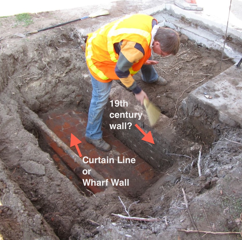
Dr. Eric Poplin preps the walls prior to mapping their location
This colonial-era wall, initiated by an act of the South Carolina legislature in 1694, runs parallel to modern East Bay Street, and in this specific site is literally sandwiched between the street curb and the sidewalk. It once stood approximately six feet above the street, but after being demolished down to street level in 1785, it’s now more than two feet below grade. The present top surface is approximately 26.5 inches wide, which is roughly half the width of the nearby redan walls excavated in 2008 and 2009. The bright red and orange bricks and the bright white mortar are an exact match to the colonial fortification materials found at the Tradd Street Redan, the Half-Moon Battery, and Granville’s Bastion.

The wall roughly follows the north-south axis along East Bay Street
Once the top of the old curtain wall was located and its identity confirmed, the exposed portion was measured, photographed, and mapped by archaeologists and Task Force members Martha Zierden (of the Charleston Museum) and Eric Poplin (of Brockington and Associates). Immediately afterward, the wall was covered with earth and the sidewalk and street repaved. The wall is now hidden below the surface again for its own protection, but the data gathered during this brief exploration will contribute greatly to the ongoing effort to map the remnants of Charleston’s colonial fortifications with great precision. In future, a few more similarly brief, shallow digs along the east side of East Bay Street would allow us to positively locate the entire length of old “wharf wall,” which once stretched approximately 2,566 feet along our waterfront.
The Task Force extends its thanks to Charleston Water System for its generosity and to the crew from Anson Construction for their enthusiasm. We eagerly look forward to future collaborations!
9 October 2012
New Signage at South Adger’s Wharf!
Posted by Nic Butler, Ph.D. under archaeology, Charleston, fortifications, HCF, history, Lower Market, South Adger's Wharf, Tradd Street RedanLeave a Comment
The Mayor’s Walled City Task Force is very pleased to announce that the long-awaited interpretive signage has been installed at the intersection of East Bay Street and South Adger’s Wharf, where archaeological digs in January 2008 and June 2009 uncovered the remnants of the colonial-era redan (or salient angle) that stood at the east end of Tradd Street. The signage consists of two handsome, illustrated text panels, created by the History Workshop, which offer a brief overview of Charleston’s colonial fortifications and also explain the mission of the Mayor’s Walled City Task Force. More importantly, these panels summarize the recent archaeology at South Adger’s Wharf, and serve to mark the site of that important exploration of our city’s colonial fabric. Note also that between the signs stands a small fragment of the parapet (uppermost part of the wall) of the Tradd Street redan that was unearthed from this site during our excavations. For more information about these panels, take a look at the the following images, or take a stroll down East Bay Street and see them yourself!

Looking northeast from the east end of Tradd Street

Looking southeast from the east end of Tradd Street

Click the image above to enlarge

Click the image above to enlarge
26 June 2009
Tradd Street Redan Dig, Day 20
Posted by Nic Butler, Ph.D. under archaeology, Charleston, Charleston Museum, fortifications, history, programs, South Adger's Wharf, Tradd Street Redan1 Comment
Yesterday I neglected to thank Robert Behre, columnist with the Charleston Post and Courier, for his good article (and video) of the “buried treasure” that has been uncovered at the east end of Tradd Street this month. Over the past several weeks his three articles about this dig have definitely enhanced our visibility, and we appreciate the public attention given to this educational venture.

Bags of artifacts ready for the lab at the Charleston Museum
Since the digging finished yesterday, the dozen College of Charleston archaeology students helped Martha Zierden of the Charleston Museum to sort the labeled bags of artifacts accumulated during the past four weeks. Martha says the total number of ceramic sherds, bottle fragments, bone, and other items is still unclear, but it’s definitely in the thousands. A few double glazed windows in perfect condition were retrieved, it’s clear however that many windows did not get so lucky. The task of processing and preserving this material begins now and will continue for many months. This long and laborious project costs money, too, so we ask everyone to please consider donating to the Walled City Task Force or directly to the Charleston Museum in order to help Martha with this important work.

Striking the set on on the final day of the dig
This plan for this dig was hatched by the Mayor’s Walled City Task Force many, many months ago, but it was conducted this month as a “field school” course through the College of Charleston. The students laboring here in the sun and rain over the past four weeks are receiving course credit for their work, and this morning they had their final exam. Following that somber ritual, the students and and their course leaders, Martha Zierden and Barbara Borg, gathered all the tools, equipment, supplies, and artifacts and began packing up the Museum’s old field truck. Like the end a theatrical run, the actors on this archaeological stage pitched in to strike the set and say a bittersweet goodbye to the experience.
The only task remaining was to re-cover the redan that they have worked so hard to unearth. Compared to the past four weeks of painstaking, meticulous digging and study, the process of filling the excavation units went by in the blink of an eye. For this task we turned over the stage to two familiar faces, James “Tiny” Bonnett and Leroy Young of Charleston Water System, who so ably assisted us with heavy equipment in January 2008 and again this week. Leroy brought in fresh fill dirt to cover the redan, and James gingerly directed the backhoe to move the dirt into position and tamped it down. Below are a few photos of this “finale.”


The fence and signage at the dig site will remain for a few more days, and next week the city will repave the portion of asphalt parking lot disturbed by this project.
Many visitors to the dig site have expressed dismay that we planned to fill the excavation at the end of June. Exposed to the elements, especially direct sunlight, however, the old brick and wood that we’ve been studying would rapidly begin to decay and crumble. It’s in everyone’s best interest to protect this historic site, and re-covering it offers the best short-term solution. Until such time as there is a plan for a safe and secure method of displaying or viewing the remnants of the old redan, we’ll just let it rest. Once a plan has been designed and approved, then the money must be secured to bring the plan to fruition. In the near future we’ll definitely be beating the drum to raise funds for this purpose, and we hope members of the community will express their enthusiasm for creating a window into the past by lending a hand. If you feel inclined to assist in funding such a project I encourage you to contact Katherine Saunders, co-chair of the Mayor’s Walled City Task Force and associate director of preservation at the Historic Charleston Foundation.
Don’t forget about the upcoming program at the Charleston County Public Library on Tuesday, June 30th, at 6:30 p.m. We’ll review the past four weeks of archaeology and talk about all the lessons learned during this great experience. Please come!
25 June 2009
Tradd Street Redan Dig, Day 19
Posted by Nic Butler, Ph.D. under archaeology, Charleston, fortifications, HCF, history, South Adger's Wharf, Tradd Street Redan[2] Comments
I am so thankful to have had the opportunity to participate in today’s digging at the historic east end of Tradd Street. I will always remember this miserably hot, intolerably bright June day as one of the highlights of my life in Charleston. With the skilled assistance of team members from Charleston Water System, the city’s Storm Water Service, and Dr. Eric Poplin‘s intrepid coaxing of the city’s mega-vacuum, we got to the bottom of the redan brickwork, more than eight feet below the top of the redan, and studied its foundation. In short, we traveled back in time to take a brief once-in-a lifetime peek at the handiwork of African and European laborers in Charleston in the late 1690s.


(click the images above to enlarge)
The bulk of the day was spent scooping and vacuuming out the water, mud, brick bats, pebbles, and ballast stones from an area about ten feet along the south face of the base of the redan’s south wall, extending approximately three feet southward from the exposed brick (see the photos above). The goal was to find the bottom edge of the brick, to study the foundation for this massive wall of solid brick, and to record its dimensions. By the end of the day, we had the answers that we had been so eagerly awaiting. I took a dozens of photographs and even some video of this activity, but it will take me a few days or weeks to digest and edit this material. For the moment, therefore, I’ll simply summarize the findings and report more at a later date.
 The brickwork of this redan extends 101 inches—nearly eight and a half feet—from the exposed top surface, along the outer slope of the wall, down to the bottom of the lowest brick course. If one remembers that prior to 1785 this wall extended a further six feet above their street level, then it is truly impressive to think that this was once a solid mass of bricks approximately fourteen feet high. The photo at left shows College of Charleston students with archaeologist Eric Poplin recording the height and location of the bottom of the wall. Below left is an image of the measuring instrument perched on Eric’s trowel at the base of the wall. Below center and right are probably the my best and last views of the full scale of the redan’s exposed south face.


(click the images above to enlarge)
At the level where the brickwork ends, approximately eleven to twelve feet below modern street level, we found a line of cypress planks, approximately two inches thick, which appear to run parallel to the edge of the bricks. Since we used a backhoe (a step up from yesterday’s smaller track-hoe) to clear away part of the mud from this area, a few chunks of this cypress plank were brought to the surface (see the photos below). As you can see, it looks as if it had been hewn yesterday.


(click the images above to enlarge)
We were not surprised to see cypress planks under the brick because architects Albert Simons and Samuel Lapham reported seeing the same when they encountered the foundation of Granville’s Bastion during their expansion of the Missroon House (40 East Bay Street) in 1925. At that time Simons and Lapham also reported seeing, but did not photograph, palmetto lots directly below their cypress planks, so we expected to see palmetto, too. Today, however, we learned that the cypress planks of this redan are resting on a thick nest of small vertical cypress piles.


(click the images above to enlarge)
The three images above are the first photographs ever taken of a foundation of Charleston’s waterfront fortifications, which commenced building in the late 1690s (see our time line). As you can see, the horizontal cypress planks, which were a little damaged by our excavation, are pressing all the weight of the bricks above them onto a number of vertical, rough-hewn cypress stakes of varying sizes. We saw no signs of palmetto logs below this material. I am ecstatic to have had the privilege of climbing ankle-deep in the mud with Dr. Poplin to see this first hand. I hope our readers are similarly impressed!
Today was the final day of digging. Friday morning the excavated areas will be refilled with fresh dirt, and next week a layer of asphalt will return. Yes, there is talk of designing a permanent “window” of some sort over the redan, but nothing has yet been designed and no money raised for its construction. If you feel inclined to assist in funding such a project I encourage you to contact Katherine Saunders, co-chair of the Mayor’s Walled City Task Force and associate director of preservation at the Historic Charleston Foundation.
Don’t forget about the upcoming program at the Charleston County Public Library on Tuesday, June 30th, at 6:30 p.m. We’ll review the past four weeks of archaeology and talk about all the lessons learned during this great experience. Please come!
 Subscribe via email