At the beginning of the eighteenth century, South Carolina’s colonial government raised a fortified trace of earthen walls and moats around the nucleus of urban Charleston. These defensive works constrained the town’s growth for more than twenty years, but then quietly vanished before a burst of civic expansion in the mid-1730s. Questions of when and why the earthworks were dismantled have baffled generations of historians and inspired competing theories. In today’s program, we’ll unpack the forgotten story of government neglect that gradually reduced the “Walled City” during the late 1720s.

Over the past several years, I’ve crafted a number of podcast essays about Charleston’s early fortifications. My goal has been to explain not only the chronology of the urban fortifications, but also the broader historical context that defined their rise and fall. The principal source for this information is the extant manuscript journals of South Carolina’s provincial government, augmented by related government documents, which I’ve examined in numerous visits to the South Carolina Department of Archives and History in Columbia over the last two decades. As I described in Episode No. 230, for example, records created during the early years of the eighteenth century provide a relatively clear picture of when and why civic leaders decided to enclose the colonial capital within a network of walls surrounded by a moat: Fear of an imminent Spanish attack in late 1703 inspired the provincial government to appropriate funds for the rapid construction of the Charleston enceinte—a fortified enclosure—which was effectively completed by the end of 1704.

Similarly, government records created over the ensuing three decades contain numerous references to the repair and maintenance of the brick curtain wall along the east side of East Bay Street and the earthen walls enclosing the south, north, and west sides of Charleston. The extant documents might not contain as many details as we’d like to see, but they represent a nearly-continuous paper trail for tracing the evolution of the town’s early fortifications.

Reading through South Carolina’s legislative journals of the 1720s and early 1730s for the first time, I expected to find the text of a discussion regarding the fate of Charleston’s earthen walls. The provincial government used tax revenue to build and maintain the enceinte surrounding the capital, so I imagined that its removal would require some act of government, like a resolution, ordinance, or statute. I found no such discussion, however, nor any sort of act or decree that might have triggered the demolition of the public earthworks. By the time I reached the legislative journals of the mid-1730s, I found discussions of extending Church Street, Dock Street, Bay Street, Tradd Street, and Broad Street beyond the boundaries of the fortifications created thirty years earlier. The earthen walls were evidently gone by 1733, but I found no explanation of how or when they disappeared.

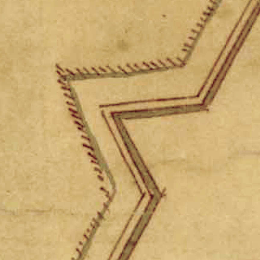
Detail from the 1739 ‘Ichnography of Charles Town at High Water,’ showing the outline of the former “enceinte” created in 1704.

Turning to secondary sources for help, I discovered that no historical text published in the past three centuries offered a reliable answer to the puzzle of Charleston’s disappearing fortifications. In fact, some observers living in the eighteenth century published inaccurate solutions to the question. For example, the well-known map printed in London in 1739, titled “The Ichnography of Charles-Town at High Water,” depicts the outline of the fortified walls that formerly constrained the south, north, and west sides of the town. A caption printed in the lower left corner of the map states that “the double lines represent the enceinte as fortified by the inhabitants for their defence against the French[,] Spaniards & Indians[;] without it were only a few houses & these not thought safe till after the signal defeat of ye Indians in the year 1717, at which time the north west & south sides were dismantled & demolished to enlarge the town.” That text is definitely inaccurate, however, because extant legislative records demonstrate South Carolina’s provincial government maintained the earthen fortifications of Charleston for several years beyond 1717.

Another brief statement about the removal of Charleston’s earthen fortifications appears within an essay about defending South Carolina, published in the Gentleman’s Magazine of London in 1745: “In Queen Anne’s war [1702–13], this place was strengthened by tolerable works on the land side, which were razed by General Nicholson, when governor, to oblige some of his particular friends.” Francis Nicholson (1655–1728) was appointed governor of South Carolina the autumn of 1720 and held that title until his death in March 1728, but he actually resided in Charleston between May 1721 and May 1725. The essay published twenty years later implies that Nicholson was somehow responsible for demolishing the earthworks in the mid-1720s, either by executive decree or by steering the provincial legislature towards that end. The extant government papers from that period do not support this theory, however, although Governor Nicholson was certainly involved in the process.

Over the past decade, I’ve re-read the extant legislative journals of the 1720s multiple times and combed archives in London searching for obscure records that might illuminate this history mystery. The answer, it turns out, was embedded in the legislative journals of the mid-1720s that I initially consulted. It did not leap off the page, but it came into focus after I revisited the clues and considered the broader context. Charleston’s first earthen walls faded out of existence over a period of several years, and the facts related to their disappearance form a rather complex narrative. For the first time in three hundred years, the real story can now be told.

This story continues at Charleston Time Machine. . . . 


If you’ve ever walked along the east side of Charleston’s East Bay Street, you’ve stood atop a forgotten brick wall that once defined the city’s waterfront. Construction of this half-mile-long “wharf wall” or “curtain line” commenced in the 1690s to separate the street from the harbor, and it formed a significant part of the town’s military defenses through the American Revolution. Knocked down to street level in the 1780s, the wall’s lower half survives just below the modern streetscape, but its precise location is now something of a mystery.

This detail from a 1784 plat of East Bay Street shows the intact brickwork of the curtain line and the redan near the east end of Lodge Alley

The waterfront curtain wall was once a prominent feature of Charleston’s built environment that would have been familiar to every inhabitant and visitor from the 1690s through the 1780s. Despite its long-standing position within the community, few historians have included this structure in their studies of the city’s evolving landscape. This neglect is not the result of bias or a lack of interest, but rather the result of a convoluted paper trail. The long but incomplete story of the construction, maintenance, and demolition of the curtain wall is inscribed within the extant manuscript records of South Carolina’s early government, which few modern readers have the opportunity or patience to peruse. After several years of combing through the surviving records at the South Carolina Department of Archives and History in Columbia, I’ve accumulated a significant amount of information related to the rise and fall of the curtain wall. The resulting mass of data forms a long and tangled narrative that doesn’t make for exciting reading, however. In order to promote a better understanding of the subject, I’ve assembled an overview organized by a series of questions focusing on the most salient points of its history.


What is the curtain wall?

The object in question is a linear structure that follows a roughly north-south axis along the east side of East Bay Street in urban Charleston. The name “curtain wall” is a modern mash-up of earlier terms. The earliest records of its existence describe the feature as a “wharf wall” because it was associated with the creation of the linear “wharf” along Charleston’s Cooper River waterfront that became East Bay Street (see Episode No. 180). In the early years of the eighteenth century, locals frequently called it the “front wall” because it served as the easternmost part of a growing network of defensive fortifications surrounding the town. Starting in 1720, locals began describing this front wall using the standard military term “curtain line”; that is, a linear feature forming a defensive link between a series of gun batteries. 


This 1762 republication of Bishop Roberts’s 1739 ‘Exact Prospect of Charles Town’ presents a stylized view of the town’s waterfront that highlights the strength and beauty of its architecture.


Even if you’re not familiar with the name, you’ve probably seen an image of the curtain wall. The most famous visual depiction is an engraving titled An Exact Prospect of Charles Town, first published in London in 1739 and then reprinted (in a slightly simplified form) in 1762. At the far left edge of that image is Granville Bastion, a diamond-shaped brick fortification with a large flag staff flying a British ensign. The remnants of that bastion are now under the Missroon House at 40 East Bay Street. The brick curtain wall extends northwardly from Granville Bastion to the east end of Tradd Street, where a V-shaped structure called a “redan” projects into the Cooper River. From the north side of the redan, the curtain wall continues northward until it intersects with the Half Moon Battery at the east end of Broad Street. From the north side of the Half-Moon, the curtain line extends to a second redan near the east end of Unity Alley, and then northward to a third redan near the east end of Lodge Alley. The waterfront wall terminates at a junction with Craven Bastion, another large, diamond-shaped structure now under the steps of the U.S. Custom House at 200 East Bay Street. 

It’s important to note, however, that this image, which appears in numerous books about early Charleston, includes a measure of artistic license. The artist purposefully omitted the several large wooden wharves that extended from East Bay Street into the Cooper River at that time. Visitors to colonial-era Charleston arriving by sea would have seen only segments of the curtain wall between the long wharves. The artist Bishop Roberts might have omitted the wharves from his illustration to emphasize the strength and beauty of Charleston’s waterfront architecture, or perhaps he was simply unable to execute the proper foreshortening of the wharves in perspective. 


What was the purpose of the curtain wall?

The structure served two important purposes. Initially, it was conceived and built as a revetment—that is, a continuous wall designed to reinforce the eastern line of Charleston’s first wharf, which we now call East Bay Street. The town’s original Cooper River waterfront was a low, sloping gradient like you see along riverbanks throughout the Lowcountry of South Carolina. Early civic leaders staked a line in the mud, roughly following the river’s high-water mark, and began building up the sandy shore behind the line. The creation of the wharf wall was the first step in creating a broad, level plain along the town’s waterfront that we see today. Its construction allowed Charlestonians to raise the level of the earth behind the wall to keep maritime commerce high and dry. This effort was an engineering first in early South Carolina, but it followed the model of similar revetment walls in other riverfront towns like London, Paris, New York, Boston, Philadelphia, Bridgetown, and many more. 

Secondarily, at the turn of the eighteenth century, South Carolina’s provincial government began to regard Charleston’s brick wharf wall as a component in the town’s expanding network of urban fortifications. The creation of six gun batteries arrayed along the length of the Cooper River waterfront in the early 1700s divided the continuous wharf wall into a segmented curtain line composed of five distinct sections. The militarization of the wharf wall also transformed its design. To protect musketeers and cannon mounted on low ship carriages along East Bay Street, civic leaders increased the height of the original wall. The resulting structure served as both a waterfront revetment and a defensive curtain for the town’s defenders in case of enemy invasion.

This story continues at Charleston Time Machine. . . . 

Fearing a Spanish attack on the capital of South Carolina in 1704, English and French colonists directed enslaved Africans to excavate many tons of earth to create a moat and earthen wall around Charleston. This continuous line of entrenchment, stretching nearly a mile in length, included numerous cannon placed within bastions and redans, while a single gateway with drawbridges controlled access into and out of the town. The defensive works of 1704 transformed Charleston into an “enceinte” or enclosed settlement that restricted the community’s growth for decades. 

Today’s program is a continuation of the storyline I started in Episode No. 221. In that program, we talked about the political and military context of 1703 that motivated the South Carolina General Assembly to order the construction of an earthen wall and moat around a portion of urban Charleston. The commencement of a new war between England, France, and Spain in 1702 had triggered a wave of anxiety in South Carolina, primarily because of the proximity of Spanish neighbors in Florida. After Spanish forces from Cuba annihilated the small English settlement at Nassau in the Bahamas, the people of Charleston feared the Carolina capital might form their next target. 

Governor Nathaniel Johnson called the South Carolina General Assembly for an emergency session in early December 1703 to formulate a defensive strategy. During two weeks of intensive work, the provincial government adopted a fortification plan drawn by a French immigrant named Samuel DuBourdieu, and engaged the services of another Frenchman, Jacques Le Grande, sieur de Lomboy (aka James Lomboy), to help the government transfer DuBourdieu’s scaled plan onto the full-sized landscape of the town. On December 23, the South Carolina legislature ratified an act ordering the construction of new fortifications to envelop the core real estate of urban Charleston and appointed Colonel William Rhett to act as sole commissioner or “manager” of the project. 

The fortification act of December 1703 initiated the creation of an “enceinte” or fortified enclosure that encompassed the highest and driest real estate within the colonial capital of South Carolina. This enceinte was not a monolithic structure, but rather a chain of interconnected structures, including several bastions, redans, and one ravelin, all of which were linked by straight curtain walls. Three sides of this enceinte—to the south, west, and north of the town—were built of earth and wood in 1704, while the long waterfront side was composed of brickwork that had commenced several years earlier and continued beyond 1704. 

This difference in material is important because the provincial government assigned different priorities to each. The government ordered the creation of the enceinte in response to what it considered a defensive emergency. At the beginning of 1704, local officials paused the unfinished brickwork along Charleston’s eastern waterfront and pivoted all available labor and resources to complete the task of enclosing the core of the town within a circuit of defensive works. As I described in Episode No. 221, the walls built around urban Charleston in 1704 were entrenchments—hastily-constructed defensive works composed of cheap, readily-available materials to address an emergency situation. Workers excavated a ditch or moat and piled the earth on the adjacent surface to construct a defensive barrier. These entrenchments were designed to last for a few years, after which the inhabitants might scrape the earthen walls back into the adjacent moat without altering the landscape in a permanent manner. The fact that it is now very difficult to find any trace of these early walls is a testament to the success of the emergency plan adopted by the South Carolina General Assembly in late 1703. 

Huguenot immigrant James Lomboy began assisting the provincial government with their fortification plans during the third week of December 1703, but his main contributions commenced in the days after the legislature adjourned for the Christmas holiday. His first task would have been to procure a number of long ropes—the sort of maritime cordage readily available in any port town of that era—to create an outline of the ditch and the walls on the surface of the ground along the proposed path of the works. Numerous fortification textbooks published in Europe during the late seventeenth and early eighteenth century describe the use of ropes to perform this preliminary step, so we might assume that Monsieur Lomboy did likewise. The lines of the ropes, augmented by wooden stakes driven at intervals, provided laborers and supervisors with clear visual guides for the digging and piling to be done.

James Lomboy did not leave behind a journal of his labors in 1703–4, but we can construct a hypothetical narrative of his work by visualizing the landscape of urban Charleston at that time. This task is simplified by the existence of a smattering of documentary clues, notes from recent physical explorations, and three contemporary or nearly-contemporary illustrations. The text version of this program on the CCPL website includes images of the well-known Crisp Map of 1711 and John Herbert’s lesser-known plan of the fortifications of Charleston, drafted in the autumn of 1721.[i] These two illustrations depict slightly different and stylized versions of the enceinte surrounding the town, but they provide invaluable visual clues. Herbert’s hand-drawn plan, for example, indicates that the enceinte enclosed just sixty-two acres at the core of urban Charleston. Bishop Roberts traced the outline of the fortified enceinte on his 1739 map titled Ichnography of Charleston at High Water, but that image was created several years after the town’s earthen walls and surrounding ditch had been demolished, and might not provide an entirely reliable visual representation.[ii]

This story continues at Charleston Time Machine. . . . 


[i] John Herbert’s manuscript plat is found at the National Archive (Kew), CO 700/Carolina6. This document, which measures approximately eighteen by twenty-four inches, contains a number of hand-written notes. An inscription at the top left corner reads “The Ichnography or Plann of the Fortifications of Charlestown, and the Streets, with the names of the Bastions[;] quantity of acres of Land, number of Gunns[,] and weight of their Shott, By his Excellencys Faithfull & Obedient Servt. John Herbert. Octobr: 27 1721.” In the lower right corner is a small scale with the following inscription: “A scale of Ten Chaines 66 Feete [sic] in a Chaine [sic] and two Ch: in an Inch.”

[ii] The Ichnography of Charles Town. At High Water, published in London in 1739 by Bishop Roberts and W. H. Toms, includes a note that had misinformed many generations of historians: “The Double Lines represent the Enceinte as fortified by the Inhabitants for their defence against the French Spaniards & Indians without it were only a few Houses & these not thought safe till after the signal Defeat of ye Indians in the Year 1717, at which time the North West & South sides were dismantled & demolished to enlarge the Town.” Contemporary records of South Carolina’s provincial government demonstrate that the lines of the enceinte were maintained, to some degree, until the spring of 1723, when official neglect formally commenced. As late as 1732, however, the local government was protecting the earthen lines of the former fortifications around the town. This topic will form the focus of a future program. 

When Queen Anne of England declared war on France and Spain in 1702, the people of South Carolina were overwhelmed with anxiety about the security of Charleston, the colonial capital. Fortifications built along the town’s eastern waterfront provided some protection against potential invaders, but the rest of the community was undefended. After a Carolina military expedition failed to capture Spanish St. Augustine, the provincial government adopted an emergency plan in late 1703 to build an entrenchment around Charleston—an earthen wall and moat to encompass the capital’s urban core. 

“Entrenchment” is a term used in military architecture to describe a pair of linear defensive components often used to protect a specific area like a town. First, workers excavate a perimeter trench or ditch or moat to slow or deter attackers on foot or on horseback. Second, workers pile the excavated earth next to the ditch to form a defensive berm. The resulting berm or “entrenchment” serves as a protective barrier to shield defenders and repulse attackers who might approach or traverse the ditch. Due to the nature of the materials involved, entrenchments are relatively inexpensive and simple to create, but they are inherently impermanent works. They are best suited for temporary occasions, like sieges, in which an attacker arrives at the perimeter of a town or castle and rapidly constructs a line of entrenchment to defend its approach. To render such earthworks more permanent, builders can add rigid materials like bundles of sticks (fascines), boards, bricks, or stones to hold the earth in place. These materials provide reinforcement, or “revetment,” that can extend the lifespan of an entrenchment indefinitely if properly maintained. 

Inset from the “Crisp Map” of 1711

The earthen entrenchments constructed within urban Charleston during the early years of eighteenth century endured on the landscape for a single generation, but they have long formed one of the most iconic and misunderstood features in the narrative of local history. The so-called “Crisp Map” of South Carolina, published in London in 1711, depicts Charleston as what we might describe as a “walled city,” outlined by a trapezoid-shaped network of walls, moats, bastions, redans, and drawbridges. This illustration has been reproduced in countless books and articles over the past three centuries, accompanied by vague descriptions of the town’s early defenses. Absent among this literature, however, is any detailed discussion of when, why, and how Charleston’s earthen walls were created. Today’s program focuses solely on the historical context that triggered the decision to enclose the town behind a defensive wall and moat. In future programs, we’ll continue this narrative by examining the methods of constructing the entrenchments, the ongoing efforts to repair them, and the eventual decision to remove them from the urban landscape.

Shortly after moving the capital of South Carolina to the peninsula known as Oyster Point in 1680, the provincial legislature authorized the construction of some rudimentary fortifications made of earth and wood along the Cooper River waterfront of “new” Charles Towne (now Charleston). Work commenced in 1694 to build a brick “wharf wall” along the east side of modern East Bay Street, measuring nearly one half of a mile in length. The storm surge associated with a strong hurricane in the autumn of 1700 ruined much of the initial brickwork, but the project quickly rebounded and continued. By the summer of 1702, South Carolina’s provincial government mounted two dozen cannon at three emplacements along the unfinished brick “wharf wall”: an unfinished brick “fort” (later called Granville Bastion) at the southern end of the Bay, a small battery of unknown materials at the east end of Tradd Street; and a completed brick Half Moon Battery at the east end of Broad Street. Beyond these works along Charleston’s eastern waterfront, the south, west, and northern parts of the town remained unguarded.

In August 1702, news arrived in Charleston that King William II of England had died in March, and his successor, Queen Anne, had declared war on France and Spain in May. Historians refer to this international conflict as Queen Anne’s War, or the War of Spanish Succession, which was destined to last for eleven years. Although most of the fighting took place in Europe, the conflict extended across the Atlantic to include the various colonies in the Americas. For the first time since the settlement of the South Carolina in 1670, a state of formal warfare now existed between the English government in Charleston and the Spanish government at St. Augustine, Florida. The Floridians had recently completed an impressive stone fortress, the Castillo de San Marcos, to defend their capital, while the waterfront defenses of Charleston remained relatively weak and unfinished. After learning of the new declaration of war, South Carolina’s provincial government was compelled to consider methods of improving the fortifications around its capital as quickly and cheaply as possible.

This story continues at Charleston Time Machine. . . . 

The Half-Moon Battery is a historic structure in urban Charleston that formed part of the town’s earliest fortifications. Construction of its curving brick wall commenced in the mid-1690s, and the structure was completed and armed in 1702. Its cannon defended the Carolina capital and fired salutes to mark civic occasions until the upper part of the battery was demolished in 1768 to facilitate the construction of the present Old Exchange. Now partially visible within the dungeon of that historic building, the fabric of the Half-Moon Battery provides a valuable glimpse of the city’s colonial past.

Detail of the Half-Moon Battery from Bishop Roberts’s Ichnography of Charles-Town (1739)

Standing at the east end of Broad Street and overlooking Charleston Harbor, the Half-Moon Battery played a central role in the geography and history of South Carolina’s colonial capital. Despite its significance, generations of historians have been frustrated by the paucity of details relating to its creation. The chronology of its demolition has been known for some time, but the story of its genesis and evolution has eluded previous scholars. The summary presented in today’s program is based on a close study of the sparse references to the battery found in the extant records of the colony’s provincial government, which paid for its construction, maintenance, and destruction. We’ll discuss the social and commercial activities that took place around the Half-Moon in future programs; for the moment, we’ll focus on the rise and fall of the structure itself.

Charleston’s Half-Moon Battery is a unique structure within South Carolina, but its design reflects the traditions of European military architecture in the centuries preceding the founding the Carolina Colony in 1670. In the vocabulary of that discipline, the term “battery” describes a defensive structure that is not fully enclosed like a fort. A battery can stand alone as a detached fortification, or it can form part of a continuous line of defensive works. The term “half-moon battery,” also called a demi-lune or lunette, typically describes a semicircular structure projecting outward from a defensive line.

Numerous examples of circular and semi-circular fortifications were built across Europe during the Medieval and Renaissance Eras, but the popularity of such designs began to fade in the sixteenth century. To defend towns and cities against increasingly-powerful artillery weapons, military engineers moved away from the high walls and rounded turrets that characterized older fortifications and embraced new designs featuring lower defensive walls punctuated by angular projections. Half-moon structures continued to be built during this stylistic transition, however, as seen in the early Spanish Caribbean colonies such as Hispaniola, Puerto Rico, Cuba, and during the early-seventeenth century in the English colonies of Bermuda, Barbados, and others.

Rounded defensive structures became increasingly rare as the science of fortification evolved during the long European wars of the seventeenth century. By the 1690s, when Charleston’s Half-Moon Battery was built, its design would have seemed antiquated and outdated to most military engineers. Nevertheless, this Carolina structure was not an isolated anomaly. Sebastian de Vauban, the leading fortification engineer of late-seventeenth-century Europe, for example, designed a similar half-moon structure, called Fort Lupin, during the late 1680s. Standing on the river banks of Saint-Nazaire-sur-Charente, just south of La Rochelle, the semicircular shape of Fort Lupin might have been familiar to some of the French Huguenot refugees who emigrated to South Carolina during that turbulent decade.

As I mentioned in Episode No. 98, the map of Charleston drawn in 1686 by Huguenot immigrant Jean Boyd depicts a physical mass projecting from the east end of Broad Street that we might describe as having a semi-circular or half-moon shape. This feature, which Boyd did not specifically describe or identify, probably represents a combination of natural and man-made elements; that is, a naturally-occurring scarp of dry land projecting slightly from the shore line that the settlers outlined and augmented with wooden pilings driven into the mud to suit their defensive needs during the late 1670s or early 1680s. Although the demolition of this early half-moon is not recorded in any known documents, the brick semicircle erected in the 1690s occupies the same physical space as the feature depicted in Jean Boyd’s map of 1686. Rather than describing Charleston’s Half-Moon Battery of the 1690s as an example of an outdated fortification design, therefore, it might be more accurate to view its construction as the robust renovation of a pre-existing half-moon revetment built of less-durable materials at the same site more than a decade earlier. . . . 

This story continues at Charleston Time Machine.