programs


On a quiet morning three hundred and ten years ago, in September 1706, five French warships sailed into Charleston harbor carrying a thousand French, Spanish, and Native American warriors.  Their mission, sanctioned by King Louis the 14th of France, was to destroy Charleston and to force the English to abandon the young colony of South Carolina.

Detail of an illustration from P. C. Coker's book, Charleston's Maritime Heritage, 1670-1865

Detail of an illustration from P. C. Coker’s book, Charleston’s Maritime Heritage, 1670-1865

Our colonial militia bravely resisted, however, and over a period of two weeks these international forces clashed in a number of skirmishes, from the Charleston peninsula, to James Island, Hobcaw Point, Shem Creek, all the way to Sewee Bay.  In the end, the South Carolina militia was victorious, and the surviving French and Spanish forces retreated in humiliation.

For several generations after the invasion of 1706, this dramatic episode was remembered in our community as a major turning point in the preservation of South Carolina. As part of the larger international struggle for empire in North America, the failed French and Spanish attempt to destroy Charleston helped to ensure that English (later British) settlers would continue to dominate the mainland.

Unfortunately, the story of the 1706 invasion is unfamiliar to most South Carolinians today.  The Mayor’s Walled City Task Force, as part of its efforts to promote knowledge of Charleston’s colonial-era fortifications, would like to increase public awareness of this awesome episode.  We think it’s an exciting story of action and international intrigue that every Sandlapper should know, and we’re inviting the public to a free program titled

Invasion 1706: South Carolina

vs. France and Spain

  • Wednesday, 21 September 2016 at 6 p.m., Charleston County Public Library Auditorium, 68 Calhoun Street, Charleston SC 29401

How does one find evidence of an earthen wall and moat that were dismantled nearly 300 years ago?  In urban Charleston, a traditional archaeological excavation is not always possible because the built environment is now quite dense, and because there are a myriad of private property concerns.  An alternative is to use ground penetrating radar (GPR), which allows one to “see” features below the surface without disturbing the ground at all.  But can GPR technology identify a centuries-old earthen feature that now might be just a stain in the ground?  That’s the question the Walled City Task force hopes to answer this summer with a test in the school parking lot of downtown Charleston’s First Baptist Church.

In the late afternoon of Tuesday, June 21st 2016, task force members gathered at the First Baptist parking lot to meet with Dr. Jon Marcoux, an archaeologist and professor at Salve Regina University in Newport, Rhode Island.  While in town conducting an archaeological field school at Charles Towne Landing, Jon offered to work with the Task Force to perform some quick GPR work downtown, and we steered him toward the aforementioned parking lot.  Why?  Because it’s a relatively open area that has been relatively undeveloped, and might afford us the best opportunity to locate and measure the earthen wall and moat that once protected the southern side of early colonial Charleston.

In December 1703 the South Carolina General Assembly voted to surround the highest and dryest 62 acres of the town with a system of fortifications constructed mostly out of earth and wood.  They had obtained credible intelligence that Spanish soldiers from St. Augustine and Havana were massing for an invasion of South Carolina, and there was little time to spare.  The eastern part of the town, along the Cooper River waterfront, was already being fortified with a solid brick wall that had commenced in 1696, but the remaining south, north, and west sides of the settlement were naked.  With great haste, the provincial government pressed the enslaved Africans belonging to both town and country inhabitants into work on an entrenchment—an earthen wall and adjoining moat—to surround the remaining parts of the town.  The resulting fortifications created a “walled city,” which was “largely perfected” by October 1704. The earliest known view of these fortifications was published in London by coffee roaster Edward Crisp in 1711, in a map commonly called “The Crisp Map.”

A portion of the "Crisp Map" of 1711, showing urban "Charles Town."

A portion of the “Crisp Map” of 1711, showing urban “Charles Town.”

The present school parking lot of First Baptist Church is located approximately midway between Church and Meeting and Meeting Streets in downtown Charleston, slightly north of Water Street (which was formerly Vanderhorst’s Creek) and south of Tradd Street.  By laying a 1721 map of the town’s fortifications over a modern Google Earth view of this site, and attempting to rectify the differing scales of these maps, we determined that a significant portion of the earthen wall and moat might be located under the northeast area of the present parking lot.  In the image below, I’ve used a red square to outline the approximate size of the area surveyed on 21 June 2016.

1721_map_South_wall_overlay

With permission from the kind folks at First Baptist Church, we created a temporary grid of approximately twenty by twenty-five meters of uninterrupted space in the asphalt-paved parking lot.  We could have done a slightly larger area, but our efforts were restricted by time, a large storm water drain, and an errant parked vehicle.  Jon used a 400 MHz GPR antenna, which is capable of “seeing” a few meters deep, but in our sandy soil the resolution is a bit compromised.

With the grid established, the process of acquiring the data was pretty simple: Jon pushed the GPR antenna across the parking lot in a series of north-south parallel lines, spaced 50 cm apart.  It’s not very exciting to watch, but here are a couple of images to illustrate the repetitive back-and-force nature of the work (with archaeologist Ron Anthony as human placeholder):

Jon heading north

Jon heading north

Jon heading south

Jon heading south

The GPR equipment includes a real-time display that shows the operator a rough outline of the earth below the antenna.  During our work on Tuesday, Jon observed a repeating pattern of “slumping”—a feature appearing to trail off from shallow to deep—that might indicate an edge of the moat.  If this turns out to be the case, it will be the first time that anyone has located evidence of the town’s early earthen walls and moat that were dismantled in the early 1730s.

Dr. Marcoux is again busy with his field school, and will soon return to Rhode Island.  We’ll have to wait a few weeks for him to compile and analyse the data, but we’ll keep our fingers crossed.  If you’d like to learn more about this investigative process and the results, you’ll have a chance in late August, when I’ll host a public program at the Charleston County Public Library.

Searching for Colonial Charleston’s South Wall

  • Tuesday, 30 August 2016 at 6 p.m., at Charleston County Public Library Auditorium, 68 Calhoun Street, 29401. 

The accumulated fortifications that surrounded urban Charleston in the spring of 1780 proved insufficient to withstand a powerful British siege, and the town ultimately surrendered to the invading army on the twelfth day of May.  The details of that long, bloody siege have been discussed by many historians (most ably in Carl Borick’s 2003 book, A Gallant Defense), but the relative calm that settled over the Charleston after the surrender has received far less attention.  During that period of two years, seven months, and two days, the denizens of urban Charleston lived under a repressive yet oddly conscientious shadow of British martial law.  Those who publicly pledged loyalty to the Crown enjoyed greater personal and commercial freedoms, of course, while those who scorned the occupying power enjoyed few liberties and lived under the eyes of constant surveillance.

1780_Investiture_Charleston

The Investiture of Charleston, S.C.,” a ca. 1780 British map now among the collections of the U.S. Library of Congress

Carl Borick’s 2012 book, Relieve Us of this Burden, provides a much-needed examination of the British treatment of American prisoners of war following the capture of Charleston.  But what about the lives of the town’s civilian population? The British military authorities created a “Board of Police” to administer the town, a system that actually marked an improvement over the old Provincial government’s relatively negligent rule of unincorporated Charles-Town.  Commissioners were appointed to oversee the markets, interments, streets and address numbers, and civil suits.  For many loyalist citizens, the town was running smoother than ever and business opportunities were ample.  For most rebels, however, the two-and-a-half year occupation reinforced their anger and fueled their desire to push their enemy out of South Carolina.  The British intended used the capture of Charleston as an example to pacify the rest of the state into submission, but their gross mismanagement of the situation ultimately gave strength to the American resistance.

If you’d like to learn more about this unsung episode in South Carolina history,  please join me for a new lecture titled

The British Occupation of Charleston, 1780–1782

  • Wednesday, 13 April 2015 at 6 p.m., at Charleston County Public Library Auditorium, 68 Calhoun Street, 29401. 

In past programs we’ve discussed the histories of the most prominent features of Charleston’s early fortifications, such as Granville Bastion, Craven Bastion, and the Half-Moon Battery. Numerous details regarding these works can be found among the surviving records of South Carolina colonial General Assembly and other archival sources, so we know a good bit about their design, location, and demolition.

For the next program, however, I’m going to attempt to tell the story of the lesser-known bastions of the walled city; specifically, the bastions named Ashley, Carteret, and Colleton, as well as the enigmatic structure known as Blake’s Bastion or Blake’s Battery. These structures existed contemporaneously with the aforementioned bastions, during the early years of the eighteenth century, but relatively little is known about them. For a variety of reasons, these lesser bastions merited less attention from the denizens of early Charleston, and thus it’s now difficult for us to tell their stories. The following is a brief summary of what I’ve been able to learn by reading all of the surviving journals of our colonial government.

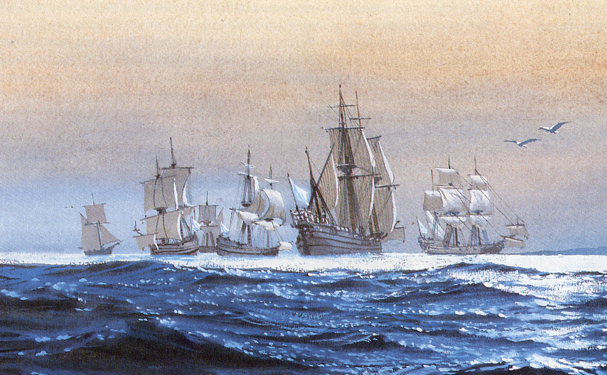
When credible intelligence of a Spanish plan to invade Charleston reached the South Carolina General Assembly in December 1703, the town’s fortifications consisted of an unfinished brick “fortress” at the south end of [East] Bay Street, a recently finished brick “Half-Moon Battery” at the east end of Broad Street, and a brick wall along the waterfront connecting the fortress and the battery. The assembly voted to begin immediately the construction of fortifications around the most defensible part of the town (roughly 62 acres of high land between Vanderhorst Creek to the south and Daniel’s Creek to the north), by means of a chain of bastions and redans (also called “salient angles”) connected by an earthen wall (or “entrenchment”) and surrounded by a moat. These works, which were “largely perfected” by October 1704, transformed urban Charleston into a “walled city” and endured for nearly three decades.

The corners of the trapezoid-shaped walled city were protected by diamond-shaped works called bastions, each of which was named for one of the Lords Proprietors who owned the Carolina colony. The brick “fortress” at the southeast corner was named Granville Bastion, while the new brick work at the northeast corner was named Craven Bastion. These large structures were maintained and used into the 1780s, and consequently we know a good bit about their history. The other bastions didn’t last nearly as long, and we know far less about them.

A close-up view of the map of Charles Town published in 1711 by Edward Crisp, highlighting the

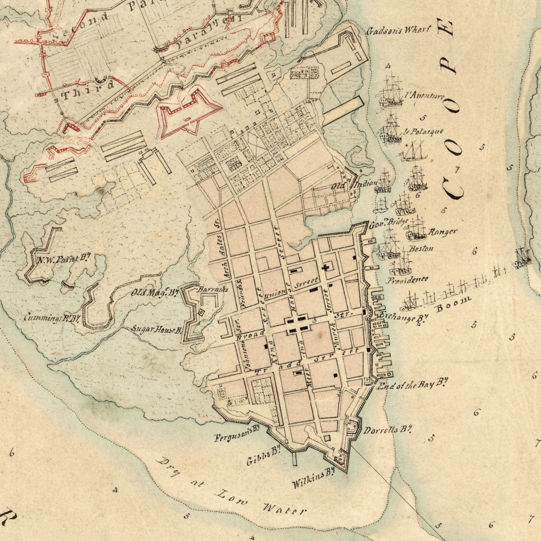
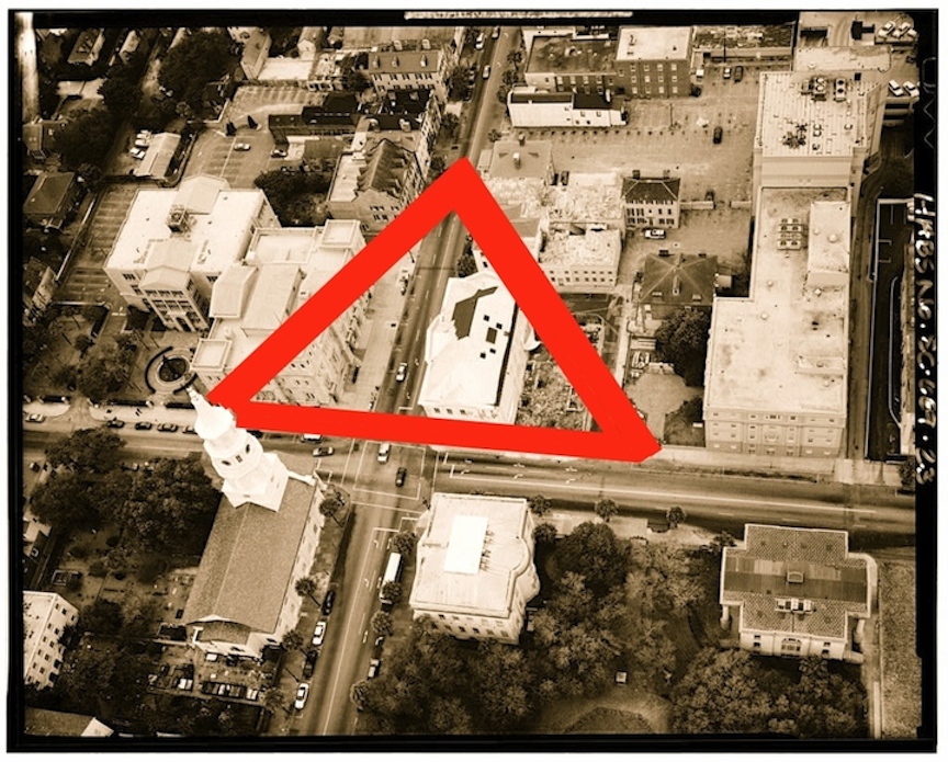
A close-up view of the map of Charles Town published in 1711 by Edward Crisp, highlighting the “lesser-known” bastions.

Colleton Bastion, the southwest corner of the walled city, stood approximately on the site now occupied by the First Scots (Presbyterian) Church at the southwest corner of Tradd and Meeting Streets. It was constructed and armed in 1704, but its cannon were removed to the “curtain line” along East Bay Street sometime between November 1721 and November 1723. No descriptions of its appearance or dimensions are known to exist. Colleton Bastion was gone by the spring of 1733, when the newly formed Presbyterian congregation purchased the site and began building their first church.

Carteret Bastion formed the northwest corner of the town wall, but its precise location is a bit of a mystery. It probably stood somewhere very near the northwest corner of Meeting Street and Horlbeck Alley/Cumberland Street, but we’re not yet sure. The matter is complicated by the fact that the northward trajectory of Meeting Street was altered slightly in the years immediately after the bastion was removed. Archaeological testing in the early 1980s and early 2000s eliminated the southwest and southeast corners as possible sites of this bastion, and anecdotal evidence suggests that at least part of it may have covered the northeast corner of that intersection. Like Colleton Bastion, we know that Carteret Bastion was armed and ready by late 1704, but by December 1723 its cannon had been removed to augment the arsenal at Craven Bastion. Similarly, we know nothing about the appearance or dimensions of Carteret Bastion.

Ashley Bastion stood due west of Granville Bastion, and may have originally been intended to form the southwest corner of a square “fortress” planned in 1696–97. Its shape is unclear in the “Crisp Map” of 1711, but in Col. John Herbert’s “Ichnography or Plann of the Fortifications of Charlestown,” drawn on 21 October 1721 (now among the records of the National Archive of the United Kingdom), Ashley Bastion is drawn as a hexagonal structure of indistinct size. Although its placement between Granville Bastion and Colleton Bastion may seem irrational, we know Ashley Bastion stood on the west side of a creek or inlet and swamp, and thus its location enhanced the security of the town’s southern side. Beyond these facts, we know little about the size, construction, or precise location of Ashley Bastion. Like the other lesser bastions, it had been stripped of its armaments (and probably demolished) by December 1723.

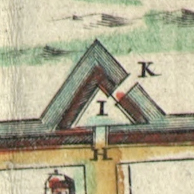
Blake’s Bastion, also called Blake’s Battery, was not technically a bastion. Rather, it was a “V”-shaped detached work, like a fleche, placed a short distance due south of Granville Bastion. Due to the sparse number of surviving documentary references to its existence, however, it is unclear whether Blake’s Battery was built before or after the construction of its neighboring bastion. Tactically, the purpose of this work was no doubt to defend the mouth of the small creek or inlet that ran between Granville Bastion and Ashley Bastion. Although we know nothing about its size or precise location, we know that Blake’s Battery was built at least partly of brick. In December 1712, when work commenced on the construction of “the new brick church” that became St. Philip’s Church, the South Carolina General Assembly (who funded the church) ordered Col. William Rhett to oversee the removal of “the bricks that compose the battery called Blakes Battery” to the site of the new church. After that reference, Blake’s Battery disappears from the historical record.

If you’d like to learn more about these long-forgotten fortifications, and perhaps help me puzzle through the documentary evidence, please join me for an illustrated lecture titled:

“The Lesser-Known Bastions of Early Charleston”

Wednesday, August 12th 2015 at 6 p.m.

Charleston County Public Library Auditorium, 68 Calhoun Street, 29401

Johnson’s Ravelin, also known as Johnson’s Cover’d Half Moon, was a man-made triangular island (of sorts) that guarded the only land entrance into Charleston for approximately thirty years.  Designed in December 1703 and dismantled in the early 1730s, this important defensive work was once a major landmark of our city’s built environment.  Today, however, it’s completely unfamiliar to most of the residents and tourists who pass over its remnants at the modern intersection of Broad and Meeting Streets.

The history of Johnson’s Ravelin begins in December 1703, when Governor Nathaniel Johnson called an emergency session of the South Carolina General Assembly in Charleston.  Credible intelligence had just been received, the governor informed the legislators, that Spanish forces were massing at Havana and St. Augustine for an invasion of South Carolina, and immediate action was required to prepare an adequate defense of the colony.  After discussions and debates, the legislature voted to fund a new system of fortifications to surround the highest, driest land in the capital, Charles Town, with a new system of fortifications.  Two French Huguenot refugees were summoned to design the enceinte and to lay out the walls and moats that would encircle the town for the next three decades.

One of the most impressive features of the 62-acre trapezoid enceinte of Charleston was the ravelin, a detached work designed to guard the only landward entrance to the town.  This feature was not a local invention, of course, but rather a standard component of European-style fortifications that was described and illustrated in every military textbook of the late seventeenth century.  French engineers under Louis XIV were among the best and most prolific practitioners of fortification construction during that era, and so it is telling that the English government of early South Carolina turned to French civilian immigrants for advice in this moment of military crisis.  The English borrowed the French term ravelin, but occasionally they used an English equivalent phrase “covered half-moon,” so-called because this feature allows musketeers (that’s the correct term) to “cover” or defend a semicircular sweep of land in front of the town gate.

By October 1704, Governor Johnson reported to the Lords Proprietors of Carolina that the new works around Charleston were “nearly perfected.”  The earliest known illustration of the enceinte of Charleston appears in map published in London in 1711, the so-called “Crisp Map.”  The two images below are details from that map.  The first shows an extreme close-up of the ravelin with features labled “H,” “I,” and “K” (remember that the letters “I” and “J” were interchangeable at this time), while the second image shows the accompanying explanation of those three features.

1711_Crisp_ravelin
1711_Crisp_caption_detail

As you can see, the ravelin or “cover’d Half Moon” named for Governor Johnson included not one, but two drawbridges leading to the town gate.  Persons traveling to Charleston from the country came southward down the “broad path” (King Street) to the site of the modern intersection of King and Queen Streets, then turned to the southeast and approached the ravelin.  The first drawbridge “in ye Half Moon” (letter K) stretched along a northwest-southeast trajectory, perpendicular to the ravelin’s outer moat.  Having crossed over that bridge onto the ravelin proper (letter I), one then turned approximately 45 degrees to face due east and then crossed over a second drawbridge “in ye Line” (letter H) and passed through (or under) the gateway into the intersection of Meeting and Broad Streets.

These drawbridges, or at least the outer one, were still present and being repaired in the late 1720s, despite an often-cited but inaccurate notation found on a 1739 map of Charleston stating that the town’s early fortifications were removed in 1717.  In reality, the ravelin and its associated features were dismantled in the early 1730s, though the exact date is lost among some missing legislative records of that era.  It was during the early 1730s that the physical limits of the town began to expand rapidly, as a truce reigned between Britain and Spain and South Carolina—now finally a “Royal” colony—settled into a brief era of peace and prosperity.

The obsolete ravelin was soon forgotten, but remnants of its moat continued to linger for many years. Shortly after the 1743 completion of the provincial armory, near the southwest corner of Broad and Meeting Streets, the keepers of the public arms complained that the building’s proximity to an adjacent “pond” was causing the weapons to rust and decay. There was no natural “pond” at this site, however; the water was simply a vestige of the old moat. A similar problem was found a decade later at the northwest corner of Broad and Meeting Streets, where the South Carolina government planned to build its state house (now the Charleston County Historic Courthouse). The commissioners appointed to construct the state house objected to that site, noting in the spring of 1752 that “the ground is so loose and full of quick-sands, as to render it insufficient to support the weight intended to be laid upon it.” That site had once been high, dry ground, but the former moat surrounding the ravelin had compromised the integrity of the soil.

In the image below, I’ve taken a 1995 HABS photograph of the intersection of Broad and Meeting Streets and drawn heavy red lines to indicate the approximate location of the moat surrounding Johnson’s Ravelin.  The placement of these lines is not entirely hypothetical; rather, they are based on eighteenth-century documentary descriptions and archaeological evidence from the late 1990s.
1995_HABS_&_ravelin

While the old State House / Charleston County Courthouse was undergoing massive renovations in 1999, workers found the buried remains of several large cedar posts that once supported the outer drawbridge (marked “K” in the Crisp Map above). In addition, archaeologists studying the courtyard immediately north of the courthouse found evidence of the moat on the east and northwest edges of their excavations. By combining these physical clues with local documentary evidence and illustrations taken from published fortification textbooks, we can begin to reconstruct the appearance of Johnson’s Ravelin in the early eighteenth century. It’s a work in progress, but if you’d like to learn more about this topic, please join me for a lecture titled:

“Johnson’s Ravelin: Charleston’s First Town Gate”

Wednesday, May 27th 2015 at 6 p.m.

2nd Floor Classroom, Charleston County Public Library, 68 Calhoun Street, 29401.

Next Page »