How does one find evidence of an earthen wall and moat that were dismantled nearly 300 years ago? In urban Charleston, a traditional archaeological excavation is not always possible because the built environment is now quite dense, and because there are a myriad of private property concerns. An alternative is to use ground penetrating radar (GPR), which allows one to “see” features below the surface without disturbing the ground at all. But can GPR technology identify a centuries-old earthen feature that now might be just a stain in the ground? That’s the question the Walled City Task force hopes to answer this summer with a test in the school parking lot of downtown Charleston’s First Baptist Church.
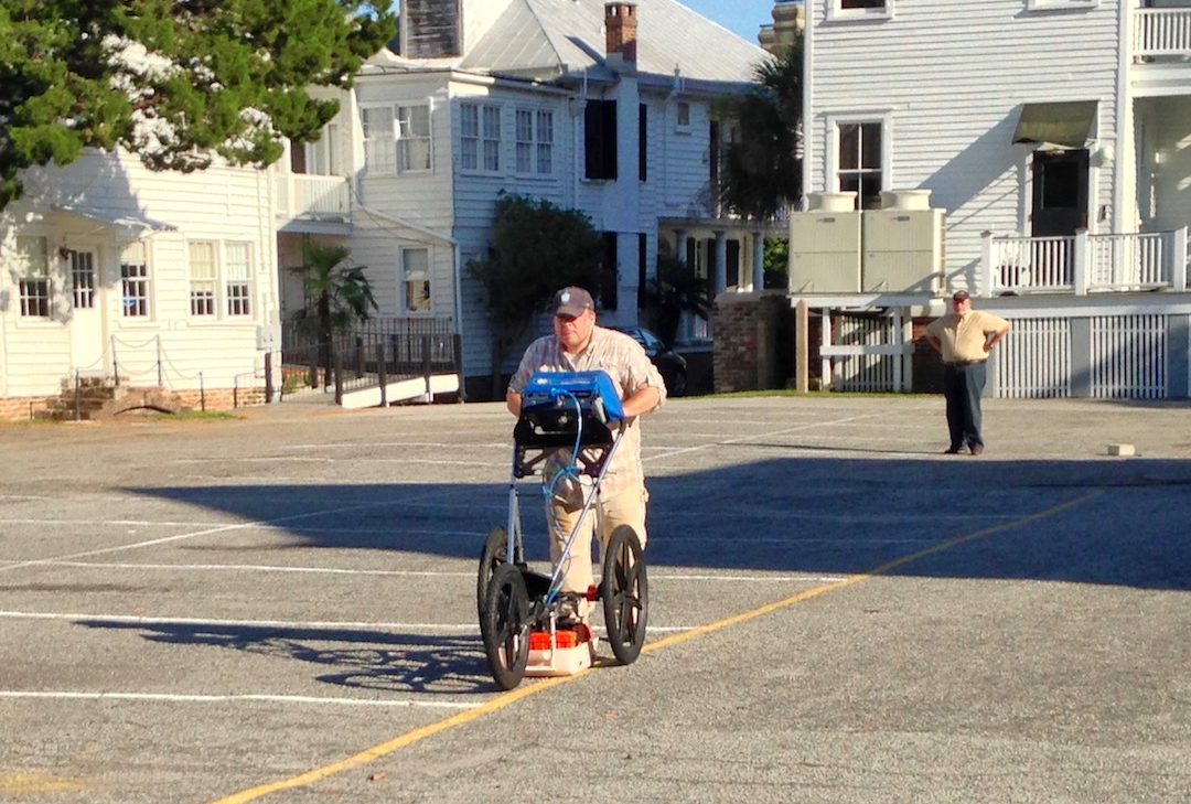
In the late afternoon of Tuesday, June 21st 2016, task force members gathered at the First Baptist parking lot to meet with Dr. Jon Marcoux, an archaeologist and professor at Salve Regina University in Newport, Rhode Island. While in town conducting an archaeological field school at Charles Towne Landing, Jon offered to work with the Task Force to perform some quick GPR work downtown, and we steered him toward the aforementioned parking lot. Why? Because it’s a relatively open area that has been relatively undeveloped, and might afford us the best opportunity to locate and measure the earthen wall and moat that once protected the southern side of early colonial Charleston.
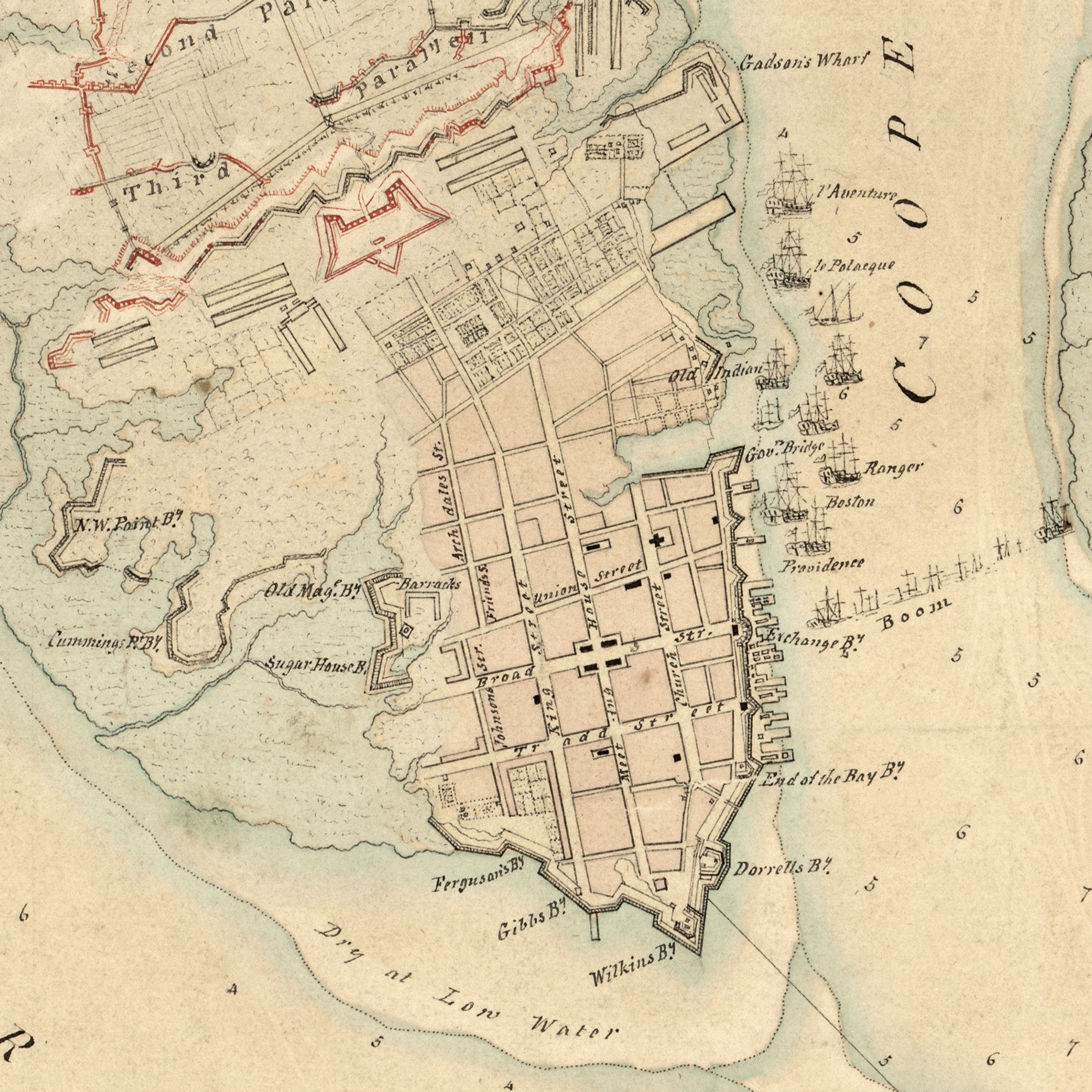
In December 1703 the South Carolina General Assembly voted to surround the highest and dryest 62 acres of the town with a system of fortifications constructed mostly out of earth and wood. They had obtained credible intelligence that Spanish soldiers from St. Augustine and Havana were massing for an invasion of South Carolina, and there was little time to spare. The eastern part of the town, along the Cooper River waterfront, was already being fortified with a solid brick wall that had commenced in 1696, but the remaining south, north, and west sides of the settlement were naked. With great haste, the provincial government pressed the enslaved Africans belonging to both town and country inhabitants into work on an entrenchment—an earthen wall and adjoining moat—to surround the remaining parts of the town. The resulting fortifications created a “walled city,” which was “largely perfected” by October 1704. The earliest known view of these fortifications was published in London by coffee roaster Edward Crisp in 1711, in a map commonly called “The Crisp Map.”

A portion of the “Crisp Map” of 1711, showing urban “Charles Town.”
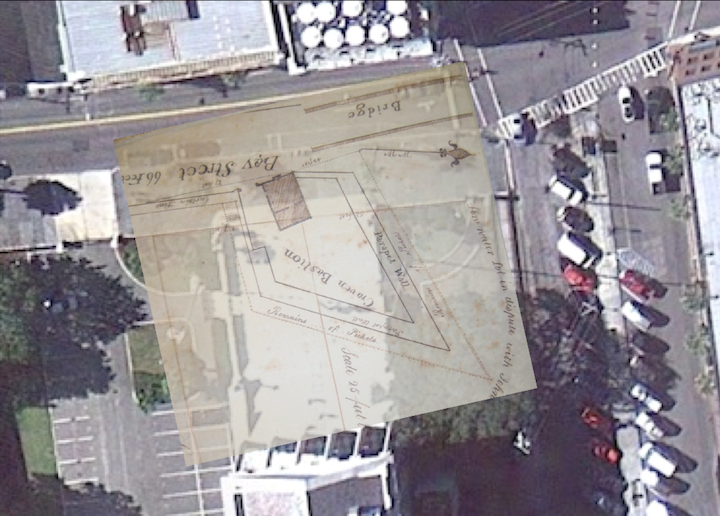
The present school parking lot of First Baptist Church is located approximately midway between Church and Meeting and Meeting Streets in downtown Charleston, slightly north of Water Street (which was formerly Vanderhorst’s Creek) and south of Tradd Street. By laying a 1721 map of the town’s fortifications over a modern Google Earth view of this site, and attempting to rectify the differing scales of these maps, we determined that a significant portion of the earthen wall and moat might be located under the northeast area of the present parking lot. In the image below, I’ve used a red square to outline the approximate size of the area surveyed on 21 June 2016.

With permission from the kind folks at First Baptist Church, we created a temporary grid of approximately twenty by twenty-five meters of uninterrupted space in the asphalt-paved parking lot. We could have done a slightly larger area, but our efforts were restricted by time, a large storm water drain, and an errant parked vehicle. Jon used a 400 MHz GPR antenna, which is capable of “seeing” a few meters deep, but in our sandy soil the resolution is a bit compromised.
With the grid established, the process of acquiring the data was pretty simple: Jon pushed the GPR antenna across the parking lot in a series of north-south parallel lines, spaced 50 cm apart. It’s not very exciting to watch, but here are a couple of images to illustrate the repetitive back-and-force nature of the work (with archaeologist Ron Anthony as human placeholder):
Jon heading north

Jon heading south
The GPR equipment includes a real-time display that shows the operator a rough outline of the earth below the antenna. During our work on Tuesday, Jon observed a repeating pattern of “slumping”—a feature appearing to trail off from shallow to deep—that might indicate an edge of the moat. If this turns out to be the case, it will be the first time that anyone has located evidence of the town’s early earthen walls and moat that were dismantled in the early 1730s.
Dr. Marcoux is again busy with his field school, and will soon return to Rhode Island. We’ll have to wait a few weeks for him to compile and analyse the data, but we’ll keep our fingers crossed. If you’d like to learn more about this investigative process and the results, you’ll have a chance in late August, when I’ll host a public program at the Charleston County Public Library.
Searching for Colonial Charleston’s South Wall
- Tuesday, 30 August 2016 at 6 p.m., at Charleston County Public Library Auditorium, 68 Calhoun Street, 29401.


 Subscribe via email