American Revolution


Have you heard the story of the Horn Work in Marion Square? You know—that mysterious, unobtrusive, lumpy slab of concrete covered with oyster shells standing in the park near King Street? Did you know it’s actually a tiny remnant of a massive fortress that once controlled access to colonial-era Charleston? And it was the city’s first citadel during the American Revolution? The Horn Work is one of Charleston’s biggest secrets hiding in plain sight, and today we’ll review the most salient chapters of its must-read story.

Horn_Work_looking_northeast_2008
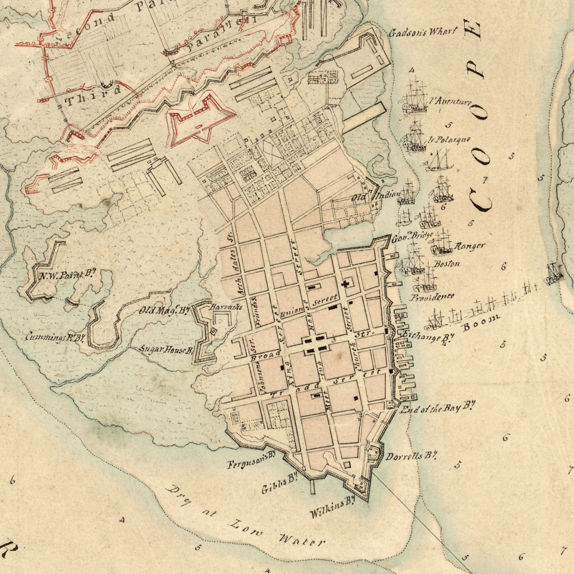
Marion Square is Charleston’s most popular public gathering space, but few visitors recognize one of the city’s most valuable historical treasures within the park. Behind a modest iron railing located approximately 125 feet east of King Street stands a mysterious slab of gray, concrete-like material. It stands approximately six feet high, is nearly ten feet long, and just over two feet wide at its base. A small metal plaque affixed to the railing is inscribed with a few disjointed words: “Remnant of Horn Work. May 1780. Siege of Charleston.” This brief text, installed in 1883, has provided little to inspire the imagination of successive generations of tourists and locals, who often pass the familiar object without a second look.

The homely remnant preserved within that iron fence merits much more attention than it currently receives, however. The brief text on its humble plaque imparts little of the dramatic story behind the massive structure that once dominated the site of Marion Square between 1758 and 1784, and which formed one of the most impressive military posts of the American Revolution. The documentary trail of evidence that illuminates the rise and fall of Charleston’s forgotten Horn Work is fragmentary, incomplete, and scattered across the globe. It’s also a complex narrative, drawn out over a number of decades and embedded within a deep context of international political and military issues.

In short, it’s a difficult story to tell in a brief synopsis. After struggling with this topic for some years, I’m going to attempt to provide an overview of the subject today, followed by a series of more detailed segments in the near future. In my experience, one of the best ways to whittle a complex topic down to a manageable size is to create a series of questions and answers that address the most salient issues. You might have heard me describe the Horn Work in recent years as “Charleston’s tabby fortress.” All of these words, drawn from the vocabulary of eighteenth-century European military engineering and the vernacular architecture of early South Carolina, might not mean anything to readers today, so let’s begin with the basics.

What is a Horn Work?

Horn_work_illustrationIn the vocabulary of military architecture, a “horn work” is a sort of broad fortress with a central gateway situated on the outskirts of a fortified town, the main purpose of which is to defend the approach or path to the settlement from the advance of potential enemies. The name itself is derived from a characteristic feature common to all horn works: a pair of half-bastions projecting outward to the left and to the right of a central wall or “curtain” that includes a gateway straddling the pathway into town. These half-bastions, which provide defenders additional angles to fire at approaching enemies, resemble horns projecting from the sides of an animal’s head. Similarly, if such a fortification included a third bastion in the center of the curtain wall, it would be called a “crown work” because of its resemblance to a monarch’s crown.

A horn work, in the general sense of the term, is a species of military architecture described in scores of fortification textbooks published in seventeenth- and eighteenth-century Europe. It was just one of a number of different types of defensive works that all military engineers of that era were expected to understand. Every species of fortification—like a bastion, a ravelin, or a redout—served a specific function and was suited to a specific situation, and their respective designs were all dictated by a well-established set of geometric rules. In the international landscape of military fortifications, Charleston’s eighteenth-century horn work was not a unique entity. In the long history of South Carolina, however, our Horn Work (for which I’m using initial capitals) was a unique and exceptional structure that merits our attention and appreciation. If nothing else, this structure might have been the only horn work ever built of tabby.

What is Tabby?

Tabby is a type of concrete that was once commonly used in the Lowcountry of early South Carolina and elsewhere. Occasionally spelled “tappy” in historic sources, this building material transformed locally-abundant natural resources into a relatively simple and cheap alternative to traditional masonry construction. Laborers transported sand, ash, broken oyster shells, and powdered lime (derived from burnt oyster shells) to a job site or retrieved them from sources on the spot. After combining those ingredients with water to form a viscous slurry, laborers poured the tabby mixture into a temporary vertical form made of parallel wooden planks connected by wooden dowels. The dimensions of the form varied but were generally in the range of one to three feet in breadth and one to two feet in depth; the length of the form was determined by a number of variables. Once the slurry had dried sufficiently to form a solid mass, the form could be dismantled by sliding the wooden dowels out of the recently-poured slab and removing the wooden planks from each side. By reassembling the same wooden form on top of the cured tabby and repeating the process a number of times, the successive layers of tabby eventually formed a solid vertical wall of any desired height. Surviving examples of tabby work in the South Carolina Lowcountry often include dowel holes and horizontal lines that illustrate such a repeated sequence of actions.

Tabby was often used in early South Carolina to pour slab floors, to construct foundations for wooden buildings, and occasionally to form the walls of entire structures. Its use seems to have been more common around Beaufort and the Port Royal area, however, as fewer examples of historic tabby construction have been found in the vicinity of Charleston. Whatever the reason behind that fact, we know that tabby was considered a novel construction material for fortifications in the Charleston area in 1757. In February of that year, the South Carolina Commissioners of Fortifications, an administrative board created in 1736 and appointed by the governor, ordered “a trial of tabby work” for some repairs to Fort Johnson on James Island. Thomas Gordon, a local bricklayer and tabby expert, then poured a pair of parallel tabby walls to form the inner and outer faces of a broad parapet that was later filled with earth to create a solid mass. The experiment apparently convinced the commissioners that tabby was more permanent that earthen fortifications and cheaper than brickwork, and they hired Gordon to do further work at Fort Johnson and elsewhere. . . .

This story continues at the Charleston Time Machine.

For the first century of its existence, the urban landscape of Charleston was dominated by an evolving ring of fortifications designed to protect the city against potential invasion by Spanish, French, and later British forces.  Our provincial legislature repeatedly devoted large sums of tax revenue for the construction and repair of walls, moats, bastions, and related works, resulting in what was undoubtedly the largest public works program in colonial South Carolina.  Despite the impressive scale of this work, however, Charleston’s modern streetscape reveals scarcely any physical trace of those early fortifications.  If the city once bristled with cannon, walls, moats, and drawbridges, how and when were such features scoured from the historical landscape?

Many of the details concerning the demilitarization of urban Charleston can be found in the public records created in the immediate aftermath of the American Revolutionary War.  Although incomplete, these records provide sufficient information to construct a robust outline of the decisions, issues, and events that took place between 1783 and 1789 and resulted in a dramatic alteration of Charleston’s urban landscape.  During this brief period, both state and city governments worked in tandem to survey, dismantle, and sell the accumulated urban fortifications.  The evidence of this cautious transition from defensive stronghold to peaceful commercial port provides two principal lessons for modern historians to consider.  On the local scale, the demolition of Charleston’s urban fortifications produced some of the most valuable documentary evidence of their dimensions, composition, and location.  On the national scale, this story presents a local example of the larger American struggle to chart a new civic course in the tumultuous environment of the Age of Revolution.

This story continues at the Charleston Time Machine.

This map of Charleston, surveyed in 1788 and published in 1790, was made shortly after the demilitarization of the city. Craven Bastion, located at the foot of the creek that would soon become Market Street, is the sole remaining fortification depicted on this map.

The accumulated fortifications that surrounded urban Charleston in the spring of 1780 proved insufficient to withstand a powerful British siege, and the town ultimately surrendered to the invading army on the twelfth day of May.  The details of that long, bloody siege have been discussed by many historians (most ably in Carl Borick’s 2003 book, A Gallant Defense), but the relative calm that settled over the Charleston after the surrender has received far less attention.  During that period of two years, seven months, and two days, the denizens of urban Charleston lived under a repressive yet oddly conscientious shadow of British martial law.  Those who publicly pledged loyalty to the Crown enjoyed greater personal and commercial freedoms, of course, while those who scorned the occupying power enjoyed few liberties and lived under the eyes of constant surveillance.

1780_Investiture_Charleston

The Investiture of Charleston, S.C.,” a ca. 1780 British map now among the collections of the U.S. Library of Congress

Carl Borick’s 2012 book, Relieve Us of this Burden, provides a much-needed examination of the British treatment of American prisoners of war following the capture of Charleston.  But what about the lives of the town’s civilian population? The British military authorities created a “Board of Police” to administer the town, a system that actually marked an improvement over the old Provincial government’s relatively negligent rule of unincorporated Charles-Town.  Commissioners were appointed to oversee the markets, interments, streets and address numbers, and civil suits.  For many loyalist citizens, the town was running smoother than ever and business opportunities were ample.  For most rebels, however, the two-and-a-half year occupation reinforced their anger and fueled their desire to push their enemy out of South Carolina.  The British intended used the capture of Charleston as an example to pacify the rest of the state into submission, but their gross mismanagement of the situation ultimately gave strength to the American resistance.

If you’d like to learn more about this unsung episode in South Carolina history,  please join me for a new lecture titled

The British Occupation of Charleston, 1780–1782

  • Wednesday, 13 April 2015 at 6 p.m., at Charleston County Public Library Auditorium, 68 Calhoun Street, 29401. 

In the one hundred years between the settlement of Charles Town on Oyster Point in 1680 and the American surrender of Charleston to the British Army in 1780, South Carolina’s provincial legislature directed massive amounts of money, resources, and labor toward the erection of defensive fortifications for the protection of the colony’s capital and main port. During that long era, South Carolinians carefully watched the movements of our Spanish and French neighbors in St. Augustine, Havana, Biloxi, Mobile, and New Orleans, ever mindful of the treat of foreign invasion. The Treaty of Paris in 1763, signed by Britain, France, and Spain, marked the beginning of an era of unprecedented peace and prosperity in the American colonies. For the first time in our colonial history, South Carolinians no longer worried about the threat of foreign invasion, and the commerce of our ports expanded rapidly.

The rift between the colonists and Britain in 1775 brought a sudden end to what had been a very prosperous decade, however, and induced South Carolinians to make rapid preparations for an imminent engagement with a new enemy. After refurbishing and expanding our fortifications, Charleston was eventually overwhelmed by the might of the British Army and capitulated on 12 May 1780. Between that time and the British evacuation of Charleston on 14 December 1782, the occupying forces maintained and even expanded some of the town’s urban fortifications as a precaution against an American counterattack. But the dawning of the year 1783 brought a fresh outlook to South Carolina. All of our enemies had retreated, and, for the first time since the founding of the colony, South Carolina’s sovereignty stood unchallenged on the world stage. At that moment our legislators, military leaders, and private citizens asked themselves, what should become of the long-standing urban fortifications crowding our principal port and capital town?

1784 newspaper notice for sale of fortifications in Charleston

1784 newspaper notice for sale of fortifications in Charleston

In retrospect, we look back at the year 1783 as the official beginning of the happy sovereignty of the United States of America, but at that time not everyone was so sanguine about our future. Following legislative debates and petitions from the merchant community, South Carolina’s General Assembly voted in March 1783 to preserve, maintain, and even expand Charleston’s urban fortifications. In the meantime, peace negotiations were proceeding in Paris between American and British diplomats, and the news of their progress was amply reported in our local newspapers.  When the City of Charleston was finally incorporated on 13 August 1783, local conversations began about who had jurisdiction over the urban defenses, and how long they might remain. Finally, at the end of its spring session in late March 1784, the South Carolina legislature voted to divest the state’s interest in Charleston’s urban fortifications. The state appointed three commissioners to manage the process of surveying, subdividing, and selling “the public lands whereon the forts and fortifications were erected, and low-water lots in Charleston,” as well as a few other non-military sites. Commencing in April 1784 and continuing to August 1789, these commissioners superintended the relatively rapid removal of the urban fortifications that had preoccupied South Carolina’s public treasury for more than a century.

The significance of this process of fortification removal, or demilitarization, for the City of Charleston cannot be overstated. The Charleston that has garnered so much devotion and praise from its denizens and tourists alike is the product of generations of civilian activity, a marriage of private enterprise and public appropriations. But the present landscape of Charleston—its infrastructure and its built environment—was shaped in part by the dominating presence of our early fortifications and by their removal in the 1780s. Understanding the physical evolution of Charleston thus requires an understanding of the physical growth of the now-absent fortifications. Fortunately for us, the five-year process of dismantling the fortifications generated a paper trail that provides important information about the location, dimensions, materials, and construction of the old works. Such information, combined with documentary evidence from colonial-era records, helps us understand how and where the fortifications were built, but it doesn’t answer all the lingering questions. The absence of many crucial documents has been a constant source of frustration in our efforts to research this topic. It is somewhat comforting, though, to see that in the 1780s some of the best legal minds in South Carolina were as confused about the legal title to some lands fortified in the colonial era as I am today.

The story of the removal of Charleston’s urban defenses forms the final installment of our 2014 lecture series on Charleston’s colonial fortifications. Please join me for a program titled

“The Demilitarization of Urban Charleston, 1784–1789”

Wednesday, December 17th at 6 p.m.

2nd Floor Classroom, Charleston County Public Library, 68 Calhoun St., 29401.

Pedestrians strolling past the swanky restaurants on Charleston’s upper King Street and promenading through the Farmers’ Market in Marion Square probably have no idea they’re treading through the heavily-fortified siege lines that once defined one of the most important battles of the American Revolution. A relatively new historical marker on the east side of King Street in the square commemorates the protracted British siege of Charleston in the spring of 1780, but it’s a minuscule reminder of a much larger scene that requires a lot of imagination to visualize. So, where were the siege lines of that historic battle, and what sorts of fortifications did the opposing forces erect? Two hundred and thirty-four years after the siege, the answers to these questions have been obscured by generations of development, but recent investigations are beginning to make the scene a bit clearer.

First, it is important to state that anyone interested in this topic should begin by reading Carl Borick’s book, A Gallant Defense: The Siege of Charleston, 1780 (University of South Carolina Press, 2003). This book provides excellent descriptions and analysis of the battle, based entirely on primary source material, and guides the reader through the many months of turmoil and bloodshed leading to the American surrender of Charleston on 12 May 1780. Mr. Borick’s book does not include a detailed analysis of the fortifications, however, because such an investigation would have derailed his book from its larger theme.

Working towards my own book on the urban fortifications of early Charleston, however, I’ve spent a lot of time gathering fragmentary details about these fortifications from surviving archival resources and the accounts of various eye witnesses to the siege. In addition, I’ve acquired copies of several manuscript maps of the era 1775–1783 that provide visual clues that help elucidate the documentary evidence. There are still more historical documents and maps out there, but locating them and obtaining copies often takes time. Nevertheless, a variety of manuscript maps from archives such as the British Library, the National Archives of the United Kingdom, the Clements Library at the University of Michigan, the Huntington Library in California, Dartmouth University Library, the Library of Congress, the South Carolina Historical Society, and of course the South Carolina Department of Archives and History, depict various parts of the suburban battlefield that is now part of urban Charleston.

Taken together, these maps illustrate, with a reasonable degree of uniformity, the many layers of fortifications employed by both sides. The American defensive lines stretched across the peninsula from the Ashley to the Cooper River, standing in ranks of graduated height from an artificial canal between John and Ann Streets to the mighty Horn Work with its back against the town limit (Boundary Street, now Calhoun Street). After sailing up the rivers and disembarking on the northern “neck” of the peninsula, the British army crept southward and encamped beyond the range of the American guns. At the beginning of April 1780, they began digging a series of siege trenches or “parallels” that zig-zagged southward from Columbus Street to the Americans’ artificial canal between John and Ann Streets. By the time British and Hessian troops drained the canal and penetrated the American defensive lines, just south of the modern intersection of King and John Streets, the end of the siege was a foregone conclusion.

Col. de Cambray's "Plan de la ville de Charlestown" at the Library of Congress

Col. de Cambray’s “Plan de la ville de Charlestown” at the Library of Congress

Most of the aforementioned maps are covered by copyrights held by their respective institutions, and a sense of scholastic respect prevents me from posting them on this website. I will, however, direct readers to a very interesting French map held by the Library of Congress that is available online and downloadable. The manuscript map in question is not signed or dated, but it appears to be the work of Colonel Louis Antoine Jean Baptiste de Cambray-Digny (1751–1822), a French engineer who served in the American army in Pennsylvania, New Jersey, Maryland, North Carolina, and Georgia before being captured by the British in Charleston in 1780. Col. de Cambray, as he was known to the South Carolina legislature in Charleston, superintended the American fortifications during the siege, and the map held at the Library of Congress includes his two-paragraph caption (in French, naturellement) that gives a wonderful description of the siege and the American fortifications. A later copy of this map (with a much abbreviated caption) was published by George W. Williams in the South Carolina Historical Magazine in April 1975 (see my bibliography), but the map at the Library of Congress includes valuable, unpublished information about the fortifications. I encourage you to click on the image of the map above and read Col. de Cambray’s caption. If you need a bit of help, here’s my translation:

­Plan of the town of Charlestown of its retrenchments and of the siege made by the English in 1780.

The night of the first of April they opened their trenches. The 10th they summoned the town [to surrender]. The 13th the 1st parallel and its batteries were finished, and began to cannonade. The 18th the 2nd parallel was finished. The 24th the besiegers mad­e a sortie to the extreme right of the 3rd parallel. The 8th of May they summoned the town to surrender. The 3rd parallel and its batteries were completed and commenced a demolishing fire [“á battre en brêche”]. The 11th they made a sap very close to the salient angle of the advance battery on the left, ­and made a passage through the advance moat from which the water had been previously drained. The 13th [sic, the 12th] the town capitulated.

The retrenchments [i.e., defensive lines] of Charlestown consisted of detached redans and curtains, the parapets 7 feet high, 16 feet thick; the moat was 12 feet deep and 26 wide. It was double palisaded, there were three rows of wells [“puits,” or trous-de-loup] beyond and some strong abatis; the contested ground [“le front attaquée,” i.e., the space between the two armies] was covered by a moat full of water 30 feet wide. The retrenchments were made in haste in less than 4 weeks in 1779, and saved the town from invasion by the English under Gen. Prevost. When the English disembarked on Johns Island there were only 200 men in garrison in the town; there was not a single cannon mounted, the abatis had been burned during the winter and had not yet been remade. When the English began their entrenchments, the garrison was about 1200 men, the militia and the sailors did nothing during the whole siege the defense was always directed by Continental troops which extended from one river to the other. During the siege the English shot 10,000 bombs 16,000 bullets and 150 carcasses. The defenders were reduced to live on nothing but rice and molasses for 4 days before the town capitulated. The garrison amounted at that time numbered 1900 [illegible] including sick, injured, servants etc. The English had at the time of the reduction 13,000 men, perfectly enveloping the town by sea and by land, and could [illegble] with success to land in the town which the defenders had guarded so vigorously.

The published diaries and memoirs of several other participants in the 1780 siege of Charleston, including those of Henry Clinton, Banastre Tarleton, Johann Hinrichs, Johann Ewald, and William Moultrie, provide additional details that help us imagine the scene. Walking around the environs of Charleston’s King Street and Marion Square, however, the modern built environment makes it difficult to visualize the battlefield of 1780. I’m in the process of attempting to overlay historic maps onto recent satellite images of Charleston, and this endeavor can prove to be very illuminating. If you’d like to see those overlays and learn more about the siege of 1780, please join me for a program titled:

“Charleston’s Fortifications of the

American Revolution, 1775–1783″

Wednesday, November 19th 2014 at 6:00 p.m.

Second Floor Classroom, Charleston County Public Library, 68 Calhoun St., 29401.