St. Augustine


After the South Carolina General Assembly resolved in the spring of 1696 to build a brick fortification in Charleston at the east end of Broad Street, a series of revisions enacted during the following year altered both its location and its design. The project was moved to a familiar beachfront, still visible today, and expanded into the shape of a formidable, modular structure. Although this imposing design was never completed, terse government documents, combined with drawings held in distant archives and surviving brickwork, provide sufficient clues to reimagine the forgotten Charleston fortress of 1697.

Granville Bastion, in short, is one of the best-remembered features and most intact remnants of the myriad fortifications that were built across Charleston’s urban landscape during the city’s first century. Copious information survives to illuminate the later years of this bastion’s history, but I have to admit that I’ve been struggling for years to interpret the documentary evidence relating to the initial stages of its construction in the late 1690s. The fortifications of early Charleston were built by the provincial government, and the extant government records from the turn of the eighteenth century contain only very sparse and somewhat confusing descriptions of that work. After reviewing the evidence countless times, I’ve reached a conclusion that I think will surprise many people: Granville Bastion began as the southeastern corner of a four-bastioned fort that was never completed. 

Granville Bastion highlighted on the "Crisp Map" of 1711

Granville Bastion highlighted on the “Crisp Map” of 1711

Today’s program is about the beginning of Charleston’s first permanent fortification project, a brick structure commenced in 1697 and later called Granville Bastion. A bastion, for those not familiar with the term, is a diamond-shaped structure that projects outward from the corner of a larger, polygonal fortification. Anyone acquainted with the early maps of urban Charleston, especially the so-called “Crisp Map” of 1711 and the two maps published by Bishop Roberts in 1739 (the “Ichnography of Charles Town” and “An Exact Prospect of Charles Town”) will recognize Granville Bastion as the southeastern corner of a line of fortifications that surrounded approximately sixty-two acres of the early town. Readers of early South Carolina history will recognize Granville Bastion as the site of the colony’s first gunpowder magazine and the official site for the ceremonial proclamation of successive royal governors and successive declarations of war. Fans of historic preservation will recall that the substantial brick remnants of Granville Bastion support the foundations of the Missroon House at 40 East Bay Street, the headquarters of the Historic Charleston Foundation. 

Those of us who are familiar with the urban landscape of colonial-era Charleston tend to take for granted the system of bastions, entrenchments, and redans that formed a trapezoid of fortifications around sixty-two acres of the town in the first quarter of the eighteenth century. Many people regard this defensive phenomenon as the result of a unified construction campaign, as if the plan to surround the town commenced with the settlement of Charleston. In reality, however, the town’s earliest fortifications grew slowly and organically, without a grand master plan. When work commenced in 1697 to build the first permanent fortifications in Charleston, the brick structure that became known as Granville Bastion was not intended as the southeastern corner of a large, fortified trapezoid surrounding a major portion of the town, but rather as the southeastern corner of a much smaller, two-acre fort. Like similar enclosed forts built at New Amsterdam (later New York), St. Augustine, and Nassau, among other places, this unnamed four-bastioned fort was designed to stand adjacent to, but separate from, the civic heart of urban Charleston.

The documentary evidence supporting this conclusion is couched within the larger story of England’s nine-year war with France known in Europe as the War of the Grand Alliance and in America as King William’s War (1689–1697). Charles Town (renamed Charleston in 1783), the capital and sole port of the southern part of the Carolina Colony, was the southernmost English outpost on the mainland of North America. The early settlers had fortified the town in the 1680s with some rudimentary fortifications built of earth and wood along the Cooper River waterfront. Back in England during the early 1690s, the Lords Proprietors who owned the Carolina Colony implored the provincial government in Charleston to construct more permanent fortifications, but factional divisions within the local Assembly stunted progress towards that objective. Furthermore, the English colonists here felt less anxious about the threat of a French attack. Carolina was then at peace with her Spanish neighbors in Florida, and the nearest French outpost was a thousand miles away in the Caribbean. . . .  

This story continues at the Charleston Time Machine.

The St. Augustine Record reported yesterday that city archaeologist Carl Halbirt had unearthed another section of a wall constructed of coquina stone that once surrounded the city. Known as the Rosario Line, the wall was constructed around 1762, at the very end of Spanish control over Florida, and once stood between six and seven feet above ground. The Record states that discovery appears to support some historians’ assertion that St. Augustine was once the most heavily defended community in this nation. “Some communities like Charleston used its resources to develop a plantation economy,” Halbirt is quoted as saying, “[while] (Spanish) St. Augustine used all its resources to defend itself against the English.”

While I agree that this is an exciting archaeological discovery, my enthusiasm is tempered by two historical points.

First, the Rosario Line, described as a relatively narrow stone wall approximately six to seven feet high, would have been a very antiquated—even impractical—style of fortification line by the middle of the eighteenth century. Stone walls shatter when hit by cannon fire, necessitating costly and time-consuming repairs. By the 1760s, the era of the Rosario Line, European military engineers like John Muller were advocating the use of thicker walls made primarily of earth as a more practical alternative. With the exception of the brick “wharf wall” along Charleston’s eastern shoreline, and the tabby bastion walls constructed in the 1750s, this city’s walls were mostly of the earthwork variety.

Second, St. Augustine’s long history as a walled city is inextricably linked to the rise of similar fortifications in colonial Charleston. Between the founding of this English city in 1670 and the end of Spanish control of Florida in 1763, Charleston and St. Augustine engaged in a sort of colonial arms race that spurred the construction of urban fortifications in both towns on a scale not witnessed in most other North American communities. While Carl Halbirt asserts that colonial Charleston spent its fortunes on developing a plantation economy, he is not yet aware of my recent research proving that Charleston’s urban fortifications were colonial South Carolina’s greatest public works project and that this city’s landscape included defensive walls, bastions, moats, and drawbridges from the 1680s to the 1780s.

I believe there are two important lessons to be learned from the recent archaeological discovery in St. Augustine. First, the city of Charleston should follow the example of St. Augustine and create a position of “city archaeologist” and enact an ordinance to mandate an archaeological survey of all public and private digs within a specified historical zone. Second, there should be a more robust line of communication between Charleston and St. Augustine so that we can accurately tell the story of the colonial tensions between these two great, old cities. Members of the Mayor’s Walled City Task Force have enjoyed some informal communication with Carl Halbirt in the past, but the time has come to establish a more substantial dialog that will enhance the historical narrative of both of our communities.

If you happen to be combing through books and the Internet for information about forts and fortifications in early South Carolina history, you’re likely to encounter an illustration titled “Arx Carolina,” along with a vague description of its subject. I’ve been asked about this image several times recently, and I’ve discovered a number of contradictory explanations. Let’s see if I can briefly set the record straight.

arx_carolina.jpg
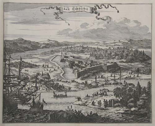
Arx Carolina is the title of an engraving by Arnold Montanus first published in Amsterdam by Dapper in 1671—one year after the English-Barbadian settlement at Albemarle Point in Carolina. It depicts a triangular fort based on contemporary European designs, and includes corner bastions, wooden revetments, a moat, drawbridge, and gate. Some history texts identify this fort as the early English settlement of Charles Town at Albemarle Point, while others claim that it represents the fortifications at New Charles Town on the peninsula between the Ashley and Cooper Rivers. There are also writers who state that it depicts the brief French settlement of Charlesfort on Parris Island, South Carolina, and still others that identify it as the French settlement of Fort Caroline near modern Jacksonville, Florida. So which is it? 

In his Narratives of Early Carolina (1911), page 140, Alexander S. Salley Jr. cites Thomas Ashe’s 1682 publication Carolina; or a Description of the Present State of that Country, which identifies “Arx Carolina” as the fort built by Jean Ribault and his followers in 1562 on what is now known as Parris Island, South Carolina. Salley states that the name is the Latin form of “Fort Charles” or “Charlesfort,” and was named for King Charles IX of France. Yates Snowden’s History of South Carolina (1930), volume 1 page 31, however, identifies “Arx Carolina” as Fort Caroline at the mouth of the St. John’s River in Florida.

Ribault’s settlers abandoned Charlesfort in 1563, barely a year after its creation, and the next French attempt at settlement in the New World was planted at the mouth of the St. John River, near modern Jacksonville, Florida. In mid-1564 French settlers erected at that site a fort that English-speaking historians call “Fort Caroline.” A year later, in the autumn of 1565, a Spanish force destroyed Fort Caroline and replaced it with a fort of their own. The French counterattacked in April 1568, however, and burned the Spanish fort, which the Spanish abandoned the following year in favor of the new settlement of St. Augustine. If you’re curious, The History of Beaufort County, South Carolina (USC Press, 1996), volume 1, pp. 23-28, includes a good description of this period, and the South Carolina Institute of Archaeology and Anthropology has a website devoted to the Santa Elena and Charlesfort.  

It is clear that the 1671 engraving of Arx Carolina does not depict either the 1670 or the 1680 English settlements of Charles Town. It is not entirely clear, though, whether this image depicts the French settlement of 1563 at Parris Island or the 1564 settlement at Jacksonville. It is significant, however, that Montanus’s 1671 image of Arx Carolina was reprinted ca. 1710 with the subtitle “Charles Fort, sur Floride.”

Yes, I’ll agree that it’s an interesting and historically significant illustration, but we have to remember that it was created more than a century after the subject it depicts was wiped off the face of the earth, and the artist certainly never laid eyes on the fort. Arx Carolina represents an important chapter in the early contests for settlement in North America, but it doesn’t have any direct connection to the fortifications of colonial Charleston, South Carolina.