archaeology


If you’ve ever walked along the east side of Charleston’s East Bay Street, you’ve stood atop a forgotten brick wall that once defined the city’s waterfront. Construction of this half-mile-long “wharf wall” or “curtain line” commenced in the 1690s to separate the street from the harbor, and it formed a significant part of the town’s military defenses through the American Revolution. Knocked down to street level in the 1780s, the wall’s lower half survives just below the modern streetscape, but its precise location is now something of a mystery.

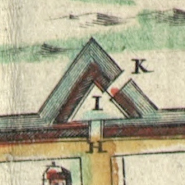
This detail from a 1784 plat of East Bay Street shows the intact brickwork of the curtain line and the redan near the east end of Lodge Alley

The waterfront curtain wall was once a prominent feature of Charleston’s built environment that would have been familiar to every inhabitant and visitor from the 1690s through the 1780s. Despite its long-standing position within the community, few historians have included this structure in their studies of the city’s evolving landscape. This neglect is not the result of bias or a lack of interest, but rather the result of a convoluted paper trail. The long but incomplete story of the construction, maintenance, and demolition of the curtain wall is inscribed within the extant manuscript records of South Carolina’s early government, which few modern readers have the opportunity or patience to peruse. After several years of combing through the surviving records at the South Carolina Department of Archives and History in Columbia, I’ve accumulated a significant amount of information related to the rise and fall of the curtain wall. The resulting mass of data forms a long and tangled narrative that doesn’t make for exciting reading, however. In order to promote a better understanding of the subject, I’ve assembled an overview organized by a series of questions focusing on the most salient points of its history.


What is the curtain wall?

The object in question is a linear structure that follows a roughly north-south axis along the east side of East Bay Street in urban Charleston. The name “curtain wall” is a modern mash-up of earlier terms. The earliest records of its existence describe the feature as a “wharf wall” because it was associated with the creation of the linear “wharf” along Charleston’s Cooper River waterfront that became East Bay Street (see Episode No. 180). In the early years of the eighteenth century, locals frequently called it the “front wall” because it served as the easternmost part of a growing network of defensive fortifications surrounding the town. Starting in 1720, locals began describing this front wall using the standard military term “curtain line”; that is, a linear feature forming a defensive link between a series of gun batteries. 


This 1762 republication of Bishop Roberts’s 1739 ‘Exact Prospect of Charles Town’ presents a stylized view of the town’s waterfront that highlights the strength and beauty of its architecture.


Even if you’re not familiar with the name, you’ve probably seen an image of the curtain wall. The most famous visual depiction is an engraving titled An Exact Prospect of Charles Town, first published in London in 1739 and then reprinted (in a slightly simplified form) in 1762. At the far left edge of that image is Granville Bastion, a diamond-shaped brick fortification with a large flag staff flying a British ensign. The remnants of that bastion are now under the Missroon House at 40 East Bay Street. The brick curtain wall extends northwardly from Granville Bastion to the east end of Tradd Street, where a V-shaped structure called a “redan” projects into the Cooper River. From the north side of the redan, the curtain wall continues northward until it intersects with the Half Moon Battery at the east end of Broad Street. From the north side of the Half-Moon, the curtain line extends to a second redan near the east end of Unity Alley, and then northward to a third redan near the east end of Lodge Alley. The waterfront wall terminates at a junction with Craven Bastion, another large, diamond-shaped structure now under the steps of the U.S. Custom House at 200 East Bay Street. 

It’s important to note, however, that this image, which appears in numerous books about early Charleston, includes a measure of artistic license. The artist purposefully omitted the several large wooden wharves that extended from East Bay Street into the Cooper River at that time. Visitors to colonial-era Charleston arriving by sea would have seen only segments of the curtain wall between the long wharves. The artist Bishop Roberts might have omitted the wharves from his illustration to emphasize the strength and beauty of Charleston’s waterfront architecture, or perhaps he was simply unable to execute the proper foreshortening of the wharves in perspective. 

What was the purpose of the curtain wall?

The structure served two important purposes. Initially, it was conceived and built as a revetment—that is, a continuous wall designed to reinforce the eastern line of Charleston’s first wharf, which we now call East Bay Street. The town’s original Cooper River waterfront was a low, sloping gradient like you see along riverbanks throughout the Lowcountry of South Carolina. Early civic leaders staked a line in the mud, roughly following the river’s high-water mark, and began building up the sandy shore behind the line. The creation of the wharf wall was the first step in creating a broad, level plain along the town’s waterfront that we see today. Its construction allowed Charlestonians to raise the level of the earth behind the wall to keep maritime commerce high and dry. This effort was an engineering first in early South Carolina, but it followed the model of similar revetment walls in other riverfront towns like London, Paris, New York, Boston, Philadelphia, Bridgetown, and many more. 

Secondarily, at the turn of the eighteenth century, South Carolina’s provincial government began to regard Charleston’s brick wharf wall as a component in the town’s expanding network of urban fortifications. The creation of six gun batteries arrayed along the length of the Cooper River waterfront in the early 1700s divided the continuous wharf wall into a segmented curtain line composed of five distinct sections. The militarization of the wharf wall also transformed its design. To protect musketeers and cannon mounted on low ship carriages along East Bay Street, civic leaders increased the height of the original wall. The resulting structure served as both a waterfront revetment and a defensive curtain for the town’s defenders in case of enemy invasion.

This story continues at Charleston Time Machine. . . . 


How does one find evidence of an earthen wall and moat that were dismantled nearly 300 years ago?  In urban Charleston, a traditional archaeological excavation is not always possible because the built environment is now quite dense, and because there are a myriad of private property concerns.  An alternative is to use ground penetrating radar (GPR), which allows one to “see” features below the surface without disturbing the ground at all.  But can GPR technology identify a centuries-old earthen feature that now might be just a stain in the ground?  That’s the question the Walled City Task force hopes to answer this summer with a test in the school parking lot of downtown Charleston’s First Baptist Church.

In the late afternoon of Tuesday, June 21st 2016, task force members gathered at the First Baptist parking lot to meet with Dr. Jon Marcoux, an archaeologist and professor at Salve Regina University in Newport, Rhode Island.  While in town conducting an archaeological field school at Charles Towne Landing, Jon offered to work with the Task Force to perform some quick GPR work downtown, and we steered him toward the aforementioned parking lot.  Why?  Because it’s a relatively open area that has been relatively undeveloped, and might afford us the best opportunity to locate and measure the earthen wall and moat that once protected the southern side of early colonial Charleston.

In December 1703 the South Carolina General Assembly voted to surround the highest and dryest 62 acres of the town with a system of fortifications constructed mostly out of earth and wood.  They had obtained credible intelligence that Spanish soldiers from St. Augustine and Havana were massing for an invasion of South Carolina, and there was little time to spare.  The eastern part of the town, along the Cooper River waterfront, was already being fortified with a solid brick wall that had commenced in 1696, but the remaining south, north, and west sides of the settlement were naked.  With great haste, the provincial government pressed the enslaved Africans belonging to both town and country inhabitants into work on an entrenchment—an earthen wall and adjoining moat—to surround the remaining parts of the town.  The resulting fortifications created a “walled city,” which was “largely perfected” by October 1704. The earliest known view of these fortifications was published in London by coffee roaster Edward Crisp in 1711, in a map commonly called “The Crisp Map.”

A portion of the "Crisp Map" of 1711, showing urban "Charles Town."

A portion of the “Crisp Map” of 1711, showing urban “Charles Town.”

The present school parking lot of First Baptist Church is located approximately midway between Church and Meeting and Meeting Streets in downtown Charleston, slightly north of Water Street (which was formerly Vanderhorst’s Creek) and south of Tradd Street.  By laying a 1721 map of the town’s fortifications over a modern Google Earth view of this site, and attempting to rectify the differing scales of these maps, we determined that a significant portion of the earthen wall and moat might be located under the northeast area of the present parking lot.  In the image below, I’ve used a red square to outline the approximate size of the area surveyed on 21 June 2016.

1721_map_South_wall_overlay

With permission from the kind folks at First Baptist Church, we created a temporary grid of approximately twenty by twenty-five meters of uninterrupted space in the asphalt-paved parking lot.  We could have done a slightly larger area, but our efforts were restricted by time, a large storm water drain, and an errant parked vehicle.  Jon used a 400 MHz GPR antenna, which is capable of “seeing” a few meters deep, but in our sandy soil the resolution is a bit compromised.

With the grid established, the process of acquiring the data was pretty simple: Jon pushed the GPR antenna across the parking lot in a series of north-south parallel lines, spaced 50 cm apart.  It’s not very exciting to watch, but here are a couple of images to illustrate the repetitive back-and-force nature of the work (with archaeologist Ron Anthony as human placeholder):

Jon heading north

Jon heading north

Jon heading south

Jon heading south

The GPR equipment includes a real-time display that shows the operator a rough outline of the earth below the antenna.  During our work on Tuesday, Jon observed a repeating pattern of “slumping”—a feature appearing to trail off from shallow to deep—that might indicate an edge of the moat.  If this turns out to be the case, it will be the first time that anyone has located evidence of the town’s early earthen walls and moat that were dismantled in the early 1730s.

Dr. Marcoux is again busy with his field school, and will soon return to Rhode Island.  We’ll have to wait a few weeks for him to compile and analyse the data, but we’ll keep our fingers crossed.  If you’d like to learn more about this investigative process and the results, you’ll have a chance in late August, when I’ll host a public program at the Charleston County Public Library.

Searching for Colonial Charleston’s South Wall

  • Tuesday, 30 August 2016 at 6 p.m., at Charleston County Public Library Auditorium, 68 Calhoun Street, 29401. 

Johnson’s Ravelin, also known as Johnson’s Cover’d Half Moon, was a man-made triangular island (of sorts) that guarded the only land entrance into Charleston for approximately thirty years.  Designed in December 1703 and dismantled in the early 1730s, this important defensive work was once a major landmark of our city’s built environment.  Today, however, it’s completely unfamiliar to most of the residents and tourists who pass over its remnants at the modern intersection of Broad and Meeting Streets.

The history of Johnson’s Ravelin begins in December 1703, when Governor Nathaniel Johnson called an emergency session of the South Carolina General Assembly in Charleston.  Credible intelligence had just been received, the governor informed the legislators, that Spanish forces were massing at Havana and St. Augustine for an invasion of South Carolina, and immediate action was required to prepare an adequate defense of the colony.  After discussions and debates, the legislature voted to fund a new system of fortifications to surround the highest, driest land in the capital, Charles Town, with a new system of fortifications.  Two French Huguenot refugees were summoned to design the enceinte and to lay out the walls and moats that would encircle the town for the next three decades.

One of the most impressive features of the 62-acre trapezoid enceinte of Charleston was the ravelin, a detached work designed to guard the only landward entrance to the town.  This feature was not a local invention, of course, but rather a standard component of European-style fortifications that was described and illustrated in every military textbook of the late seventeenth century.  French engineers under Louis XIV were among the best and most prolific practitioners of fortification construction during that era, and so it is telling that the English government of early South Carolina turned to French civilian immigrants for advice in this moment of military crisis.  The English borrowed the French term ravelin, but occasionally they used an English equivalent phrase “covered half-moon,” so-called because this feature allows musketeers (that’s the correct term) to “cover” or defend a semicircular sweep of land in front of the town gate.

By October 1704, Governor Johnson reported to the Lords Proprietors of Carolina that the new works around Charleston were “nearly perfected.”  The earliest known illustration of the enceinte of Charleston appears in map published in London in 1711, the so-called “Crisp Map.”  The two images below are details from that map.  The first shows an extreme close-up of the ravelin with features labled “H,” “I,” and “K” (remember that the letters “I” and “J” were interchangeable at this time), while the second image shows the accompanying explanation of those three features.

1711_Crisp_ravelin
1711_Crisp_caption_detail

As you can see, the ravelin or “cover’d Half Moon” named for Governor Johnson included not one, but two drawbridges leading to the town gate.  Persons traveling to Charleston from the country came southward down the “broad path” (King Street) to the site of the modern intersection of King and Queen Streets, then turned to the southeast and approached the ravelin.  The first drawbridge “in ye Half Moon” (letter K) stretched along a northwest-southeast trajectory, perpendicular to the ravelin’s outer moat.  Having crossed over that bridge onto the ravelin proper (letter I), one then turned approximately 45 degrees to face due east and then crossed over a second drawbridge “in ye Line” (letter H) and passed through (or under) the gateway into the intersection of Meeting and Broad Streets.

These drawbridges, or at least the outer one, were still present and being repaired in the late 1720s, despite an often-cited but inaccurate notation found on a 1739 map of Charleston stating that the town’s early fortifications were removed in 1717.  In reality, the ravelin and its associated features were dismantled in the early 1730s, though the exact date is lost among some missing legislative records of that era.  It was during the early 1730s that the physical limits of the town began to expand rapidly, as a truce reigned between Britain and Spain and South Carolina—now finally a “Royal” colony—settled into a brief era of peace and prosperity.

The obsolete ravelin was soon forgotten, but remnants of its moat continued to linger for many years. Shortly after the 1743 completion of the provincial armory, near the southwest corner of Broad and Meeting Streets, the keepers of the public arms complained that the building’s proximity to an adjacent “pond” was causing the weapons to rust and decay. There was no natural “pond” at this site, however; the water was simply a vestige of the old moat. A similar problem was found a decade later at the northwest corner of Broad and Meeting Streets, where the South Carolina government planned to build its state house (now the Charleston County Historic Courthouse). The commissioners appointed to construct the state house objected to that site, noting in the spring of 1752 that “the ground is so loose and full of quick-sands, as to render it insufficient to support the weight intended to be laid upon it.” That site had once been high, dry ground, but the former moat surrounding the ravelin had compromised the integrity of the soil.

In the image below, I’ve taken a 1995 HABS photograph of the intersection of Broad and Meeting Streets and drawn heavy red lines to indicate the approximate location of the moat surrounding Johnson’s Ravelin.  The placement of these lines is not entirely hypothetical; rather, they are based on eighteenth-century documentary descriptions and archaeological evidence from the late 1990s.
1995_HABS_&_ravelin

While the old State House / Charleston County Courthouse was undergoing massive renovations in 1999, workers found the buried remains of several large cedar posts that once supported the outer drawbridge (marked “K” in the Crisp Map above). In addition, archaeologists studying the courtyard immediately north of the courthouse found evidence of the moat on the east and northwest edges of their excavations. By combining these physical clues with local documentary evidence and illustrations taken from published fortification textbooks, we can begin to reconstruct the appearance of Johnson’s Ravelin in the early eighteenth century. It’s a work in progress, but if you’d like to learn more about this topic, please join me for a lecture titled:

“Johnson’s Ravelin: Charleston’s First Town Gate”

Wednesday, May 27th 2015 at 6 p.m.

2nd Floor Classroom, Charleston County Public Library, 68 Calhoun Street, 29401.

IMG_3941

Today’s archaeology at the southeast corner of King and South Battery Streets focused on one specific feature that is visible at the surface of the ground: the point at which the composition of the sea wall under investigation transitions from brick to stone. We dug on both sides of the wall in search of clues that might help us determine the vintage of the materials and the sequence of construction. Based on what we’ve seen over these two days, it appears that most of our target, the 1769 sea wall, was rebuilt during multiple repair episodes in the first half of the 19th century, and the original construction materials (brick and Bermuda stone) were deconstructed and recycled as fill behind the rebuilt wall.

In response to Robert Behre’s article in today’s edition of the Post and Courier, a number of local residents and tourists stopped by the dig site to peer into the past and ask questions. As always, it was a pleasure to share our discoveries, theories, and enthusiasm for urban archaeology.

The point at which the brick  wall transitions into a stone wall.

The point at which the brick wall transitions into a stone wall.

We commenced digging approximately 40 feet east of King Street, on the south side (water side) of the sea wall. As we learned yesterday, there is a large concrete utility chase in this area running parallel to our wall, so we knew we would only be able to excavate to a depth of two or three feet. Approximately two feet below the surface, we encountered the concrete chase and began to clean the wall for a better view. As you can see in the photo,  some masons in the past took a certain amount of care to fit and mortar irregularly shaped stones into the jagged edge of the brick work. Both of these elements, however, appear to represent nineteenth century repairs. The appearance and size of the bricks, combined with the color and composition of the mortar, suggest that these materials replaced the eighteenth-century bricks and mortar that originally composed the wall. As mentioned in yesterday’s posting, we also know that repairs to this wall were done with stone after 1811. But which came first—the brick repairs seen here, or the stone repairs? That’s a question that will require further digging through the surviving newspapers and other documentary records.

A view of the south side of the wall at the brick-stone interface.

A view of the south side of the wall at the brick-stone interface.

A view of the north side of the wall adjacent to the brick-stone interface.

A view of the north side of the wall adjacent to the brick-stone interface.


Unable to dig deeper on the south side of the wall, we turned our attention to its north side to see if there might be other clues to help decipher the brick-stone intersection. Behind (north 0f) the wall we found the same mix of fill materials as yesterday; that is, ballast stone, eighteenth-century brick bats, and a large quantity of fragmented Bermuda stone. We remain in awe of the prevalence of Bermuda stone concentrated in this small area. Whether or not the wall we’re investigating represents work completed in 1769 or extensive repairs in the 1830s, the profusion of otherwise-rare Bermuda stone at this location confirms that we’re in the right place and, at the very least, seeing the city’s attempts to maintain a very useful piece of colonial waterfront infrastructure. Like yesterday’s work, today’s study of the back fill area yielded a number of ceramic fragments that continue to indicate that this site was heavily disturbed during the first half of the nineteenth century.

Looking east at the backfill behind the sea wall (at right), showing the loose and consolidated sections of rubble materials.

Looking east at the back fill behind the sea wall (at right), showing the loose and consolidated sections of rubble materials.

In today’s case, however, we observed a difference in the nature of the fill behind the wall. Careful hand-troweling through the rubble revealed that a reasonably discrete portion of the fill was slathered in mortar, as if in an attempt to create a unified body. The extent and purpose of this mortar-bound fill is unclear, but we have a theory. The consolidated section in question is perpendicular to the wall, and perhaps was intended to act as a buttress or “counterfort” to stabilize the wall against the opposing force of the tides.

Speaking of the tides, today’s downward digging once again found water just a few feet below the surface, and it’s hard to forget that the Ashley River is just a stone’s throw away from our site. And so, hemmed in by modern utilities, streetscapes, and seeping tidal waters, we closed up our units and now begin the work of analyzing the data.

The Mayor’s Walled City Task Force extends its collective thanks to the City of Charleston (especially the Stormwater Services and Parks Departments), Clemson University, the Charleston Museum, the College of Charleston, the Charleston County Public Library, the Post and Courier, and every one who visited the site, for helping to make this brief but very productive collaborative venture a success. Our goal is to pursue and to share knowledge in an effort to increase public understanding and appreciation of Charleston’s history, and I think we’re right on target.

The dig site at the southeast corner of King and South Battery Streets in Charleston.

The dig site at the southeast corner of King and South Battery Streets in Charleston.

This morning the Walled City Task Force began a brief exploratory dig at the southeast corner of King and South Battery Streets, and we found some interesting materials. Did we find physical evidence to confirm the existence of the 1769 sea wall built of Bermuda stone and brick? Well, maybe. It’s a long story, and it’s going to take us a while to sort out the evidence and draw conclusions.

Part of the exposed brickwork at the southeast corner of King and South Battery Streets.

Part of the exposed brickwork at the southeast corner of King and South Battery Streets.

If you recall the earlier posting about this topic, we’re seeking to identify the line of bricks and stones that is visible along much of the northern edge of White Point Garden (see the photo below). This line doesn’t seem to be related to either the boundary of the park or the curb of South Battery Street, and so we suspect it is a vestige of a wall constructed in the summer of 1769 as a sea wall to protect the extensive and expensive fortifications that once stood at White Point. There is no documentary evidence to suggest that this wall was ever dismantled, and thus it would have stood as a visible, useful barrier for the neighborhood until a new wall was built around the western extension of White Point Garden ca. 1850.

Most of the early records of the City of Charleston were lost or destroyed during the chaos of the spring of 1865, however, so there is a big blind spot in our historical understanding of this site.  We know from newspaper advertisements that there was some sort of repair or refashioning of this 1769 sea wall during the early years of the nineteenth century, but the extent of that work is unclear. In October of 1811, for example, the city advertised that it needed large “building stone” for construction of the East Battery sea wall (still standing today), and also “building stone of a smaller size from fifty to two hundred weight for South-Bay-street.” In October 1812, and again as late as April 1831, the city advertised its desire to contract with someone to repair “the stone wall on South Bay.” Based on what we found today, it appears that much (but perhaps not all) of the 1769 brick sea wall was rebuilt with granite stones in the early 1800s.

The first hole revealed a bonanza of rubble fill material, including large fragments of Bermuda stone.

The first hole revealed a bonanza of rubble fill material, including large fragments of Bermuda stone.

Using a small backhoe and shovels, we dug (and later re-filled) three holes today. The first hole was on the north side (the land side) of the wall in question, approximately 100 feet east of King Street. Just a few inches below the surface, we encountered a bonanza of ballast stone, brick bats, and large chunks of Bermuda stone. The wall appears to be constructed solely of stones, and back-filled with dense rubble containing almost no artifacts. That description doesn’t match what we’re looking for, but the presence of the Bermuda stone fragments was a pleasant surprise. Charleston’s senior archaeologist, Martha Zierden of the Charleston Museum, says its very unusual to find such a concentration of Bermuda stone, even fragments of it, in Charleston. If this section of the 1769 wall was rebuilt with quarried stone ca. 1811, it would make sense that workers would excavate the surviving Bermuda stone and brick and recycle it as fill material.

The second hole, on the south side of the wall, showing nineteenth-century stone repairs and a late 20th century utility obstruction.

The second hole, on the south side of the wall, showing nineteenth-century stone repairs and a late 20th century utility obstruction.

The second hole was dug on the south side (the water side) of the wall, approximately fifteen feet west of the first hole. Here we found the relatively clean face of a granite stone wall with a slight batter or slope from top to bottom. The soil in front of the wall was completely sterile and new, because sometime in the late twentieth century the power utility company built an extensive concrete chase that runs nearly the width of the park, parallel to the wall we’re investigating. After digging down approximately three feet, that utility line prevented us from exploring this side of the wall any further. As you can see in my photograph, it appears that this section of the 1769 sea wall was also rebuilt with stone in 1811.

Martha Zierden places a photographic scale on the brick wall exposed in our third hole of the day.

Martha Zierden places a photographic scale on the brick wall exposed in our third hole of the day.

The third and final hole of the day was located just a few feet east of the corner of King and South Battery, next to the clearly exposed line of brick. After just a few seconds of breaking the surface on the north side (land side) of the wall, we began seeing fragments of ceramics and glass. Martha Zierden dated them to the first half of the nineteenth-century. We were able to remove enough fill to expose fifteen courses of brick before water began to seep into the hole (remember the Ashley River is just a stone’s throw away). Although we were pleased to finally see some intact, old brickwork, the appearance of the brick was not quite what we were expecting. We found many fragments of colonial-era brick in the fill behind the wall, but as you can see in the photo below, the bond or pattern of the layout of the brick is more reminiscent of post-colonial-era work.

The brickwork of uncertain vintage, exposed in the day's third hole.

The brickwork of uncertain vintage, exposed in the day’s third hole.

Could it be that this section of the 1769 brick sea wall was also rebuilt ca. 1811, but with brick rather than stone? The determining factor in this question might be the presence or absence of Bermuda stone at the base of the brick work. Since the bottom course of bricks was actually below the water level, we couldn’t see what was there. A tactile investigation (that is, reaching into the mud) found only coarse silt and vague fragments, which might actually represent the remnants of degraded Bermuda stone (which is soft when under water and hardens only when exposed to dry air). In short, we’re not sure of the date of this construction.

Looking west toward the intersection of King and South Battery Streets.

Looking west toward the intersection of King and South Battery Streets.

All in all, it wasn’t a bad day of archaeology, despite the high temperature of only 48. We’ll return to the scene tomorrow and try to find further evidence to help us understand the construction history of this mysterious wall. Thursday should be a warmer day, so please drop by and have a look if you’re in the neighborhood. Remember, also, that there will be a public program in late March including recap the history of the 1768-1769 sea wall and a summary of the findings from this dig.


A small fragment of Bermuda stone excavated today.

A small fragment of Bermuda stone excavated today.

Oh–and of course I have to include a photo of a Bermuda stone fragment recovered from this morning first dig. This material would have been sawed into a rectangular block originally, but as you can see now it’s quite degraded.


Next Page »