Fearing a Spanish attack on the capital of South Carolina in 1704, English and French colonists directed enslaved Africans to excavate many tons of earth to create a moat and earthen wall around Charleston. This continuous line of entrenchment, stretching nearly a mile in length, included numerous cannon placed within bastions and redans, while a single gateway with drawbridges controlled access into and out of the town. The defensive works of 1704 transformed Charleston into an “enceinte” or enclosed settlement that restricted the community’s growth for decades.
 Today’s program is a continuation of the storyline I started in Episode No. 221. In that program, we talked about the political and military context of 1703 that motivated the South Carolina General Assembly to order the construction of an earthen wall and moat around a portion of urban Charleston. The commencement of a new war between England, France, and Spain in 1702 had triggered a wave of anxiety in South Carolina, primarily because of the proximity of Spanish neighbors in Florida. After Spanish forces from Cuba annihilated the small English settlement at Nassau in the Bahamas, the people of Charleston feared the Carolina capital might form their next target.
Governor Nathaniel Johnson called the South Carolina General Assembly for an emergency session in early December 1703 to formulate a defensive strategy. During two weeks of intensive work, the provincial government adopted a fortification plan drawn by a French immigrant named Samuel DuBourdieu, and engaged the services of another Frenchman, Jacques Le Grande, sieur de Lomboy (aka James Lomboy), to help the government transfer DuBourdieu’s scaled plan onto the full-sized landscape of the town. On December 23, the South Carolina legislature ratified an act ordering the construction of new fortifications to envelop the core real estate of urban Charleston and appointed Colonel William Rhett to act as sole commissioner or “manager” of the project.
The fortification act of December 1703 initiated the creation of an “enceinte” or fortified enclosure that encompassed the highest and driest real estate within the colonial capital of South Carolina. This enceinte was not a monolithic structure, but rather a chain of interconnected structures, including several bastions, redans, and one ravelin, all of which were linked by straight curtain walls. Three sides of this enceinte—to the south, west, and north of the town—were built of earth and wood in 1704, while the long waterfront side was composed of brickwork that had commenced several years earlier and continued beyond 1704.
This difference in material is important because the provincial government assigned different priorities to each. The government ordered the creation of the enceinte in response to what it considered a defensive emergency. At the beginning of 1704, local officials paused the unfinished brickwork along Charleston’s eastern waterfront and pivoted all available labor and resources to complete the task of enclosing the core of the town within a circuit of defensive works. As I described in Episode No. 221, the walls built around urban Charleston in 1704 were entrenchments—hastily-constructed defensive works composed of cheap, readily-available materials to address an emergency situation. Workers excavated a ditch or moat and piled the earth on the adjacent surface to construct a defensive barrier. These entrenchments were designed to last for a few years, after which the inhabitants might scrape the earthen walls back into the adjacent moat without altering the landscape in a permanent manner. The fact that it is now very difficult to find any trace of these early walls is a testament to the success of the emergency plan adopted by the South Carolina General Assembly in late 1703.
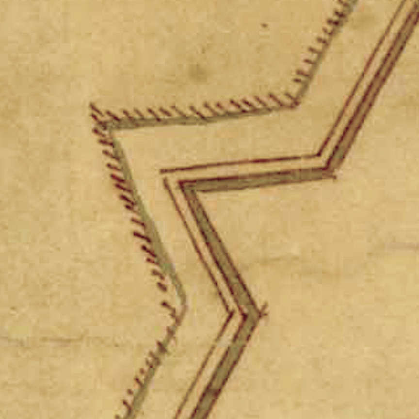
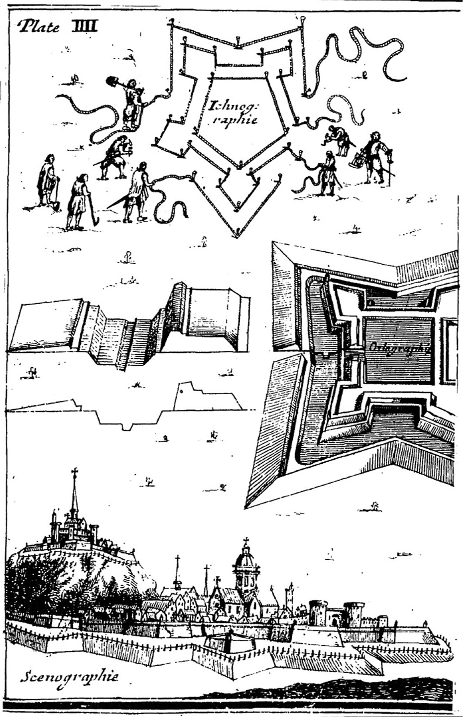 Huguenot immigrant James Lomboy began assisting the provincial government with their fortification plans during the third week of December 1703, but his main contributions commenced in the days after the legislature adjourned for the Christmas holiday. His first task would have been to procure a number of long ropes—the sort of maritime cordage readily available in any port town of that era—to create an outline of the ditch and the walls on the surface of the ground along the proposed path of the works. Numerous fortification textbooks published in Europe during the late seventeenth and early eighteenth century describe the use of ropes to perform this preliminary step, so we might assume that Monsieur Lomboy did likewise. The lines of the ropes, augmented by wooden stakes driven at intervals, provided laborers and supervisors with clear visual guides for the digging and piling to be done.
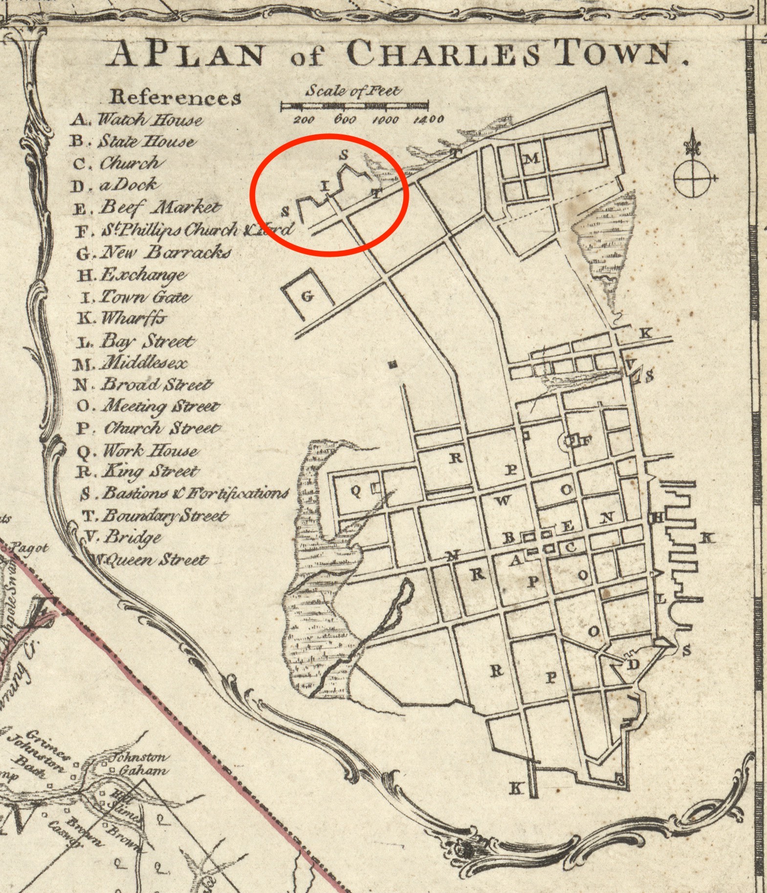
James Lomboy did not leave behind a journal of his labors in 1703–4, but we can construct a hypothetical narrative of his work by visualizing the landscape of urban Charleston at that time. This task is simplified by the existence of a smattering of documentary clues, notes from recent physical explorations, and three contemporary or nearly-contemporary illustrations. The text version of this program on the CCPL website includes images of the well-known Crisp Map of 1711 and John Herbert’s lesser-known plan of the fortifications of Charleston, drafted in the autumn of 1721.[i] These two illustrations depict slightly different and stylized versions of the enceinte surrounding the town, but they provide invaluable visual clues. Herbert’s hand-drawn plan, for example, indicates that the enceinte enclosed just sixty-two acres at the core of urban Charleston. Bishop Roberts traced the outline of the fortified enceinte on his 1739 map titled Ichnography of Charleston at High Water, but that image was created several years after the town’s earthen walls and surrounding ditch had been demolished, and might not provide an entirely reliable visual representation.[ii]
This story continues at Charleston Time Machine. . . .
[i] John Herbert’s manuscript plat is found at the National Archive (Kew), CO 700/Carolina6. This document, which measures approximately eighteen by twenty-four inches, contains a number of hand-written notes. An inscription at the top left corner reads “The Ichnography or Plann of the Fortifications of Charlestown, and the Streets, with the names of the Bastions[;] quantity of acres of Land, number of Gunns[,] and weight of their Shott, By his Excellencys Faithfull & Obedient Servt. John Herbert. Octobr: 27 1721.” In the lower right corner is a small scale with the following inscription: “A scale of Ten Chaines 66 Feete [sic] in a Chaine [sic] and two Ch: in an Inch.”
[ii] The Ichnography of Charles Town. At High Water, published in London in 1739 by Bishop Roberts and W. H. Toms, includes a note that had misinformed many generations of historians: “The Double Lines represent the Enceinte as fortified by the Inhabitants for their defence against the French Spaniards & Indians without it were only a few Houses & these not thought safe till after the signal Defeat of ye Indians in the Year 1717, at which time the North West & South sides were dismantled & demolished to enlarge the Town.” Contemporary records of South Carolina’s provincial government demonstrate that the lines of the enceinte were maintained, to some degree, until the spring of 1723, when official neglect formally commenced. As late as 1732, however, the local government was protecting the earthen lines of the former fortifications around the town. This topic will form the focus of a future program.

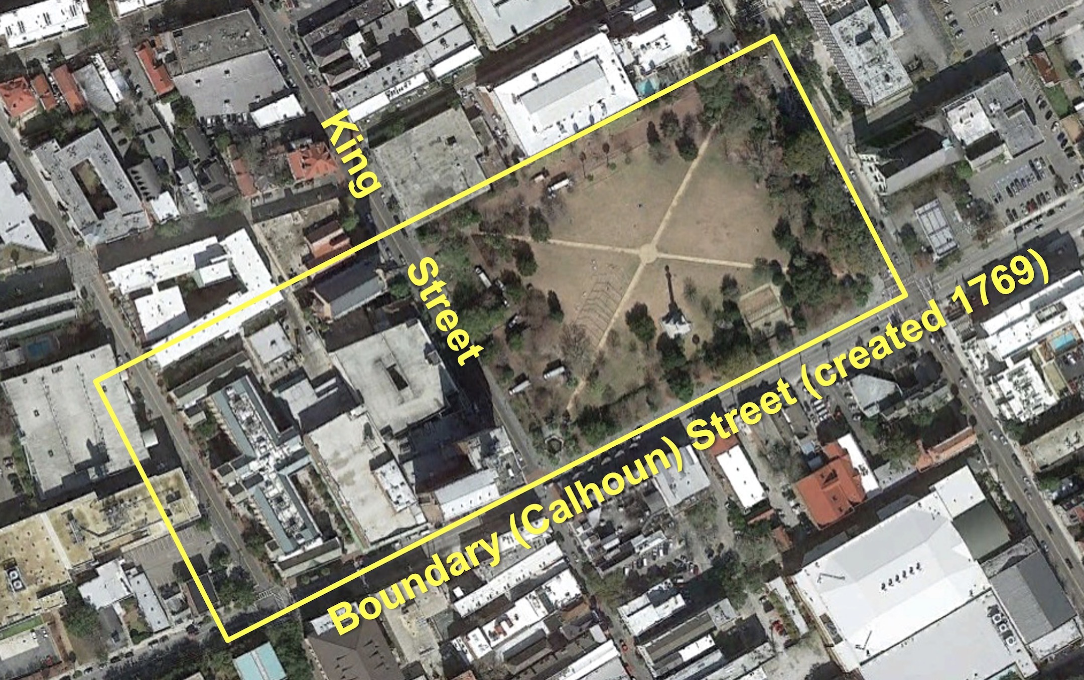
 Marion Square is Charleston’s most popular public gathering space, but few visitors recognize one of the city’s most valuable historical treasures within the park. Behind a modest iron railing located approximately 125 feet east of King Street stands a mysterious slab of gray, concrete-like material. It stands approximately six feet high, is nearly ten feet long, and just over two feet wide at its base. A small metal plaque affixed to the railing is inscribed with a few disjointed words: “Remnant of Horn Work. May 1780. Siege of Charleston.” This brief text, installed in 1883, has provided little to inspire the imagination of successive generations of tourists and locals, who often pass the familiar object without a second look.
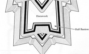 In the vocabulary of military architecture, a “horn work” is a sort of broad fortress with a central gateway situated on the outskirts of a fortified town, the main purpose of which is to defend the approach or path to the settlement from the advance of potential enemies. The name itself is derived from a characteristic feature common to all horn works: a pair of half-bastions projecting outward to the left and to the right of a central wall or “curtain” that includes a gateway straddling the pathway into town. These half-bastions, which provide defenders additional angles to fire at approaching enemies, resemble horns projecting from the sides of an animal’s head. Similarly, if such a fortification included a third bastion in the center of the curtain wall, it would be called a “crown work” because of its resemblance to a monarch’s crown.
 Subscribe via email