Johnson’s Ravelin, also known as Johnson’s Cover’d Half Moon, was a man-made triangular island (of sorts) that guarded the only land entrance into Charleston for approximately thirty years. Designed in December 1703 and dismantled in the early 1730s, this important defensive work was once a major landmark of our city’s built environment. Today, however, it’s completely unfamiliar to most of the residents and tourists who pass over its remnants at the modern intersection of Broad and Meeting Streets.
The history of Johnson’s Ravelin begins in December 1703, when Governor Nathaniel Johnson called an emergency session of the South Carolina General Assembly in Charleston. Credible intelligence had just been received, the governor informed the legislators, that Spanish forces were massing at Havana and St. Augustine for an invasion of South Carolina, and immediate action was required to prepare an adequate defense of the colony. After discussions and debates, the legislature voted to fund a new system of fortifications to surround the highest, driest land in the capital, Charles Town, with a new system of fortifications. Two French Huguenot refugees were summoned to design the enceinte and to lay out the walls and moats that would encircle the town for the next three decades.
One of the most impressive features of the 62-acre trapezoid enceinte of Charleston was the ravelin, a detached work designed to guard the only landward entrance to the town. This feature was not a local invention, of course, but rather a standard component of European-style fortifications that was described and illustrated in every military textbook of the late seventeenth century. French engineers under Louis XIV were among the best and most prolific practitioners of fortification construction during that era, and so it is telling that the English government of early South Carolina turned to French civilian immigrants for advice in this moment of military crisis. The English borrowed the French term ravelin, but occasionally they used an English equivalent phrase “covered half-moon,” so-called because this feature allows musketeers (that’s the correct term) to “cover” or defend a semicircular sweep of land in front of the town gate.
By October 1704, Governor Johnson reported to the Lords Proprietors of Carolina that the new works around Charleston were “nearly perfected.” The earliest known illustration of the enceinte of Charleston appears in map published in London in 1711, the so-called “Crisp Map.” The two images below are details from that map. The first shows an extreme close-up of the ravelin with features labled “H,” “I,” and “K” (remember that the letters “I” and “J” were interchangeable at this time), while the second image shows the accompanying explanation of those three features.
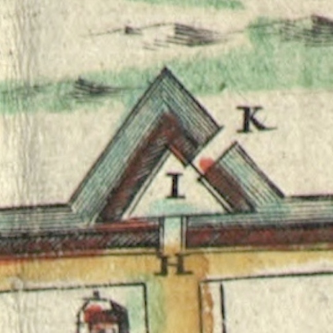

As you can see, the ravelin or “cover’d Half Moon” named for Governor Johnson included not one, but two drawbridges leading to the town gate. Persons traveling to Charleston from the country came southward down the “broad path” (King Street) to the site of the modern intersection of King and Queen Streets, then turned to the southeast and approached the ravelin. The first drawbridge “in ye Half Moon” (letter K) stretched along a northwest-southeast trajectory, perpendicular to the ravelin’s outer moat. Having crossed over that bridge onto the ravelin proper (letter I), one then turned approximately 45 degrees to face due east and then crossed over a second drawbridge “in ye Line” (letter H) and passed through (or under) the gateway into the intersection of Meeting and Broad Streets.
These drawbridges, or at least the outer one, were still present and being repaired in the late 1720s, despite an often-cited but inaccurate notation found on a 1739 map of Charleston stating that the town’s early fortifications were removed in 1717. In reality, the ravelin and its associated features were dismantled in the early 1730s, though the exact date is lost among some missing legislative records of that era. It was during the early 1730s that the physical limits of the town began to expand rapidly, as a truce reigned between Britain and Spain and South Carolina—now finally a “Royal” colony—settled into a brief era of peace and prosperity.
The obsolete ravelin was soon forgotten, but remnants of its moat continued to linger for many years. Shortly after the 1743 completion of the provincial armory, near the southwest corner of Broad and Meeting Streets, the keepers of the public arms complained that the building’s proximity to an adjacent “pond” was causing the weapons to rust and decay. There was no natural “pond” at this site, however; the water was simply a vestige of the old moat. A similar problem was found a decade later at the northwest corner of Broad and Meeting Streets, where the South Carolina government planned to build its state house (now the Charleston County Historic Courthouse). The commissioners appointed to construct the state house objected to that site, noting in the spring of 1752 that “the ground is so loose and full of quick-sands, as to render it insufficient to support the weight intended to be laid upon it.” That site had once been high, dry ground, but the former moat surrounding the ravelin had compromised the integrity of the soil.
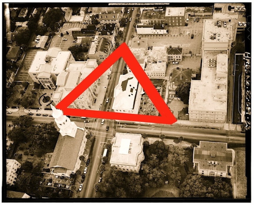
In the image below, I’ve taken a 1995 HABS photograph of the intersection of Broad and Meeting Streets and drawn heavy red lines to indicate the approximate location of the moat surrounding Johnson’s Ravelin. The placement of these lines is not entirely hypothetical; rather, they are based on eighteenth-century documentary descriptions and archaeological evidence from the late 1990s.
While the old State House / Charleston County Courthouse was undergoing massive renovations in 1999, workers found the buried remains of several large cedar posts that once supported the outer drawbridge (marked “K” in the Crisp Map above). In addition, archaeologists studying the courtyard immediately north of the courthouse found evidence of the moat on the east and northwest edges of their excavations. By combining these physical clues with local documentary evidence and illustrations taken from published fortification textbooks, we can begin to reconstruct the appearance of Johnson’s Ravelin in the early eighteenth century. It’s a work in progress, but if you’d like to learn more about this topic, please join me for a lecture titled:
“Johnson’s Ravelin: Charleston’s First Town Gate”
Wednesday, May 27th 2015 at 6 p.m.
2nd Floor Classroom, Charleston County Public Library, 68 Calhoun Street, 29401.

18 May 2015 at 11:36 am
Castillo San Marco in Saint Augustine is an example of this sort of double entryway through a ravelin. Drawbridge to enter the enclosure and then a gate to enter the ground within the castillo.
18 May 2015 at 11:39 am
Exactly right—that’s the perfect model for imagining the entry into Charleston!