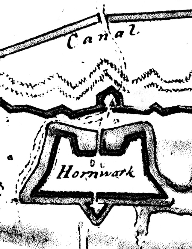
 One of the most common questions that I’m asked at “Walled City” events is “where can I see part of the fortifications that once surrounded Charleston?” Almost equally as common is the question “what’s the story behind that mound of oyster shells standing in Marion Square?” In an attempt to answer both of these questions at one time, I’m offering a program later this month titled “The Horn Work: Charleston’s Tabby Fortress, 1759-1784.” The program will be presented at the Charleston County Public Library on Monday, April 28th at 6:00 p.m., and it’s free and open to the public. We’ll take a look at some historic illustrations of the old Horn Work (including the 1781 map shown above), and try to understand the lone remnant standing in Marion Square as a small part of what was once a large fortress mounting eighteen cannon and surrounded by a moat thirty feet wide.
 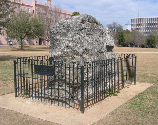 How did the “Horn Work” get its name, and when was it built? When was it demolished, and why does one small piece survive above ground? Has anyone ever searched below ground to find further evidence of its walls? For the answers to these questions, plus many more fascinating details and images, please join the Mayor’s Walled City Task Force at the Charleston County Public Library on the 28th. For more details and a printable flyer (a PDF file), please see our Upcoming Events page. I hope to see you there!
history
3 April 2008
Upcoming Program on the “Horn Work”
Posted by Nic Butler, Ph.D. under archaeology, Charleston, fortifications, history, programsLeave a Comment
19 March 2008
Task Force Members On Call
Posted by Nic Butler, Ph.D. under archaeology, Charleston, historyLeave a Comment
Last Friday, March 14th, a crew working for the City of Charleston’s Parks Department encountered some curious brickwork while digging a trench behind the Hazel Parker Playground on East Bay Street. Rather than shrugging their collective shoulders and continuing with their work, Project Manager Bill Turner picked up the telephone and called archaeologist Martha Zierden of the Charleston Museum to ask her opinion of the brickwork. Martha was working in the field beyond Charleston, however, as was archaeologist Eric Poplin of Brockington and Associates. Martha managed to contact me and Katherine Saunders, co-chair of the Walled City Task Force, and she and I met at the playground, just one block south of the recent archaeological dig at South Adger’s Wharf.
 The entrance to the Hazel Parker Playground is through a rectangular one-story brick building at 70 East Bay Street, behind which are outdoor facilities for tennis, basketball, and baseball.
 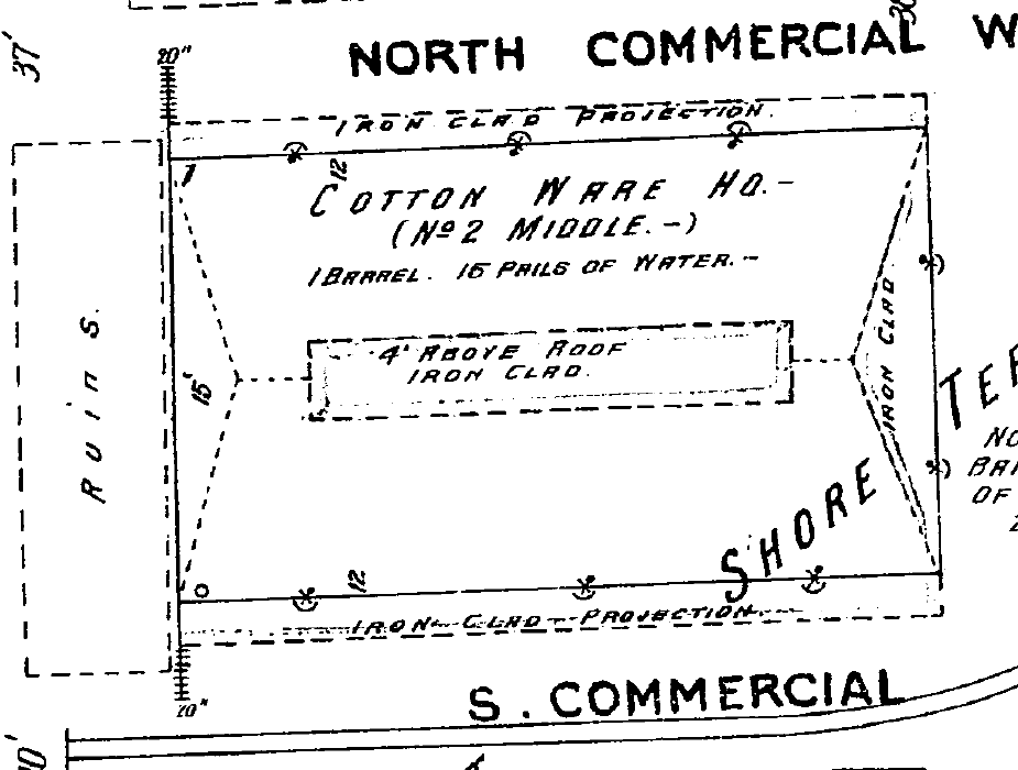 The brick building dates from the early years of the twentieth century, and is built on the site of a slightly larger three-story commercial structure that stood for most of the nineteenth century. An image of that building, from the 1884 Sanborn Insurance Map of Charleston, is seen above left. The 1902 edition of the Sanborn map of Charleston shows only “ruins” of this building, as seen here to the right.
 A work crew had recently cut a trench along the back wall of 70 East Bay Street in order to build brick buttresses to strengthen the east side of the building. In the trench they discovered a continuous line of brickwork running parallel to and about three feet east of the existing building. The western edge of this brickwork was visible in the trench (see the photo to the right below), but the eastern edge was buried below the mound of earth removed from the trench.
 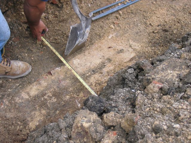 The exposed portion of brick was approximately two feet wide, but the full width of the wall could not be determined. At any rate, Katherine and I concluded that this brickwork most likely represents the foundation of the eastern wall of the nineteenth century commercial offices that once stood in front of the cotton warehouses and wharves of the Commercial Cotton Company.
While this brick foundation wall runs parallel to the old “curtain line” of the colonial fortifications along the east side of East Bay Street, it’s located more than thirty feet east of that historic wall. Our site visit last Friday didn’t turn out to be associated with the “walled city,” but we greatly appreciate the spirit of cooperation that inspired Mr. Turner to share this discovery with the Task Force. We look forward to many more such opportunities to share in the process of uncovering Charleston’s past.
3 March 2008
The Return of the Cobblestones
Posted by Nic Butler, Ph.D. under archaeology, Charleston, history, South Adger's Wharf[2] Comments
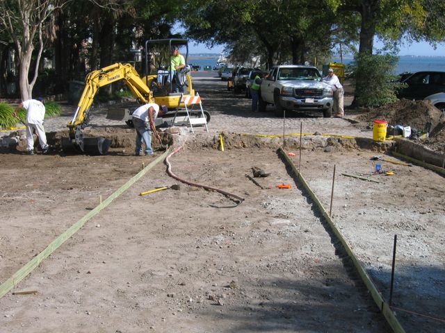
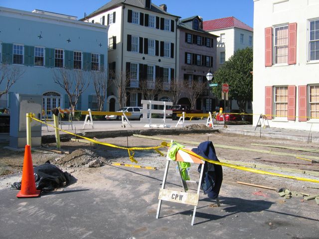
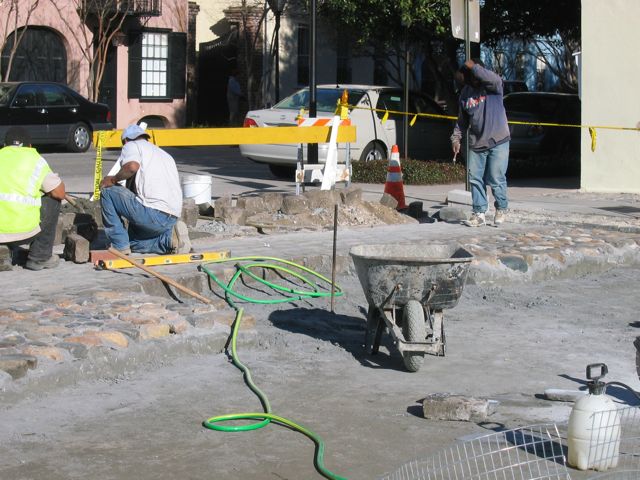
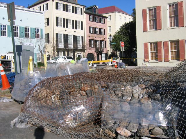
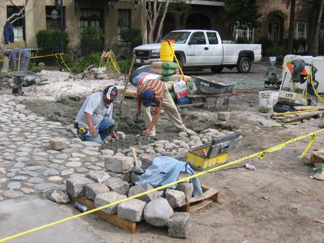
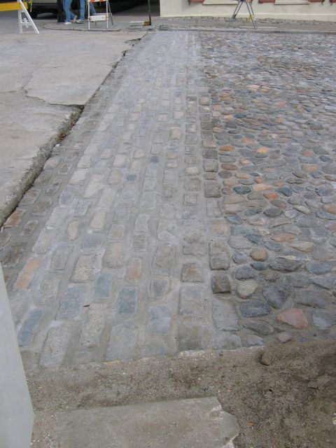
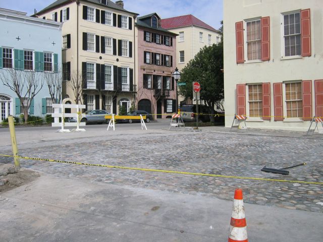
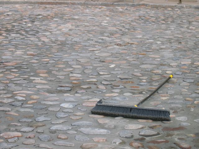
Over the past several weeks the surface of the short thoroughfare known as South Adger’s Wharf has been transformed from a patch of loose dirt to a antique-looking cobblestone street encased in concrete. The early colonial redan, uncovered in the January 2008 archaeological excavation, was re-covered with earth within hours after the dig ended. In the weeks following, the earth above the redan was compacted and leveled in order to prepare it for a “modern” street paving. Wooden forms were then laid and a thin concrete slab poured over the entire dig site. Once the concrete had cured, a crew began laying (in concrete) rows of Belgian blocks along the intersection of East Bay Street and South Adger’s Wharf. After that task was completed, palettes of odd-shaped ballast stones, the “original” (really early-twentieth-century) street surface material, were brought to the site from a storage facility. As with the Belgian blocks, the crew also used concrete to set these stones in place. While the resulting street surface now has an attractive appearance and stable foundation, the extensive (if not excessive) use of concrete does not accurately reflect the “historical” character of South Adger’s Wharf’ and has effectively entombed the old redan against future exploration.
The following photos illustrate the chronological progress of the repaving of South Adger’s Wharf, from February 5th through the 21st.


9 February 2008
Recent SAW Program
Posted by Nic Butler, Ph.D. under archaeology, Charleston, fortifications, history, programs, South Adger's WharfLeave a Comment
On 30 January 2008 the Mayor’s Walled City Task Force presented an illustrated overview of the recent archaeology at South Adger’s Wharf. Well over a hundred people came to the Charleston County Public Library’s auditorium to hear about the dig from several of the participants.
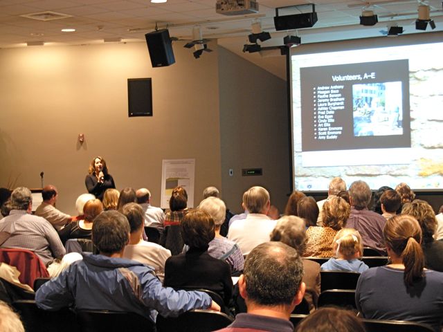 To open the program, Task Force co-chair Katherine Saunders took a few minutes to acknowledge the sponsors who made the archaeology possible and the volunteers who contributed so much to its success. Without the assistance and enthusiasm of these dozens of people, this long-anticipated project might never have come to fruition.
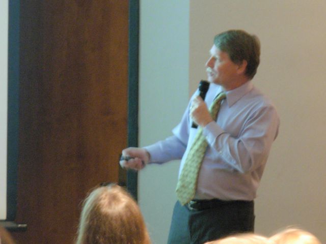
 Next, I presented an illustrated historical overview of the redan and Lower Market that once stood at the east end of Tradd Street. As you can see in the photo here, I also mentioned the building known as the Court Room and Exchange that stood just within the redan between 1723 and 1740. We were hoping to find the foundations building, but our dig site turned out to be about twenty feet north of that structure.
 Archaeologist Dr. Eric Poplin provided a great illustrated summary of the dig, with special emphasis on reading the layers of soil that we encountered. In the brief period of time since the dig concluded, Dr. Poplin had already prepared some fascinating illustrations of the stratigraphy. His color slides, and the accompanying posters created by the History Workshop, will be included in the final published report of the South Adger’s Wharf dig.
 Charleston Museum curator of archaeology Martha Zierden took the stage to discuss the collection and curation of artifacts from the recent dig. In addition to her slides and narration, Zierden and her colleague Ron Anthony brought a large number of pottery sherds, bone fragments, and other materials collected from the site. At the conclusion of the program, audience members were invited to crowd around the display table of artifacts and chat with the archaeologists.
 To conclude the program, Task Force co-chair Peter McGee extended his thanks to everyone involved for their support and hard work, and to the audience for their attention and encouragement. The recent South Adger’s Wharf dig, which uncovered about one-third of the Tradd Street redan, was so successful, Mr. McGee opined, that he hopes the Mayor’s Walled City Task Force will be able to continue its momentum in the coming year and gather support for another dig to uncover the other two-thirds of that redan. I second that proposition!
Those of you who were unable to attend this program will be pleased to know that I am currently working on a multimedia encapsulation of this program. The finished product will be made available through this website, most likely as a podcast that can be streamed over the internet or downloaded. Stay tuned for further information!
28 January 2008
South Adger’s Wharf Wrap-Up
Posted by Nic Butler, Ph.D. under archaeology, Charleston, fortifications, history, programs, South Adger's WharfLeave a Comment
It’s been more than week since the conclusion of the archaeological dig at South Adger’s Wharf, but we’re still not finished with this story. There are several developments that I’d like to bring to everyone’s attention.
First, the Charleston Post and Courier has just published a long editorial piece written by the co-chairs of the Mayor’s Walled City Task Force, Joseph H. McGee and Katherine Saunders, “Walled City Task Force Hopes to Continue Excavations.” This article provides the public with a good overview of the history and goals of the Task Force, and succinctly explains the significance of the recent archaeology at South Adger’s Wharf. Such media exposure is undoubtedly a boon to our efforts.
 Second, the dig site at South Adger’s Wharf now looks exactly like it did the day before we started our recent excavations (see “Archaeology Begins Tomorrow“). The laborious task of replacing the cobblestones will begin any day now, but in the meantime it’s a bittersweet experience to walk past the now-vacant site, as I have done several times in the past few days.
Third, I want to remind everyone that the Walled City Task Force will be presenting a public program at the Charleston County Public Library on Wednesday, January 30th, at 7:00 p.m. We’ll provide a historical overview of the redan and the Lower Market that once occupied the land at South Adger’s Wharf, and archaeologists Martha Zierden and Eric Poplin will be on hand to explain what was found.
 Subscribe via email