The Half-Moon Battery is a historic structure in urban Charleston that formed part of the town’s earliest fortifications. Construction of its curving brick wall commenced in the mid-1690s, and the structure was completed and armed in 1702. Its cannon defended the Carolina capital and fired salutes to mark civic occasions until the upper part of the battery was demolished in 1768 to facilitate the construction of the present Old Exchange. Now partially visible within the dungeon of that historic building, the fabric of the Half-Moon Battery provides a valuable glimpse of the city’s colonial past.
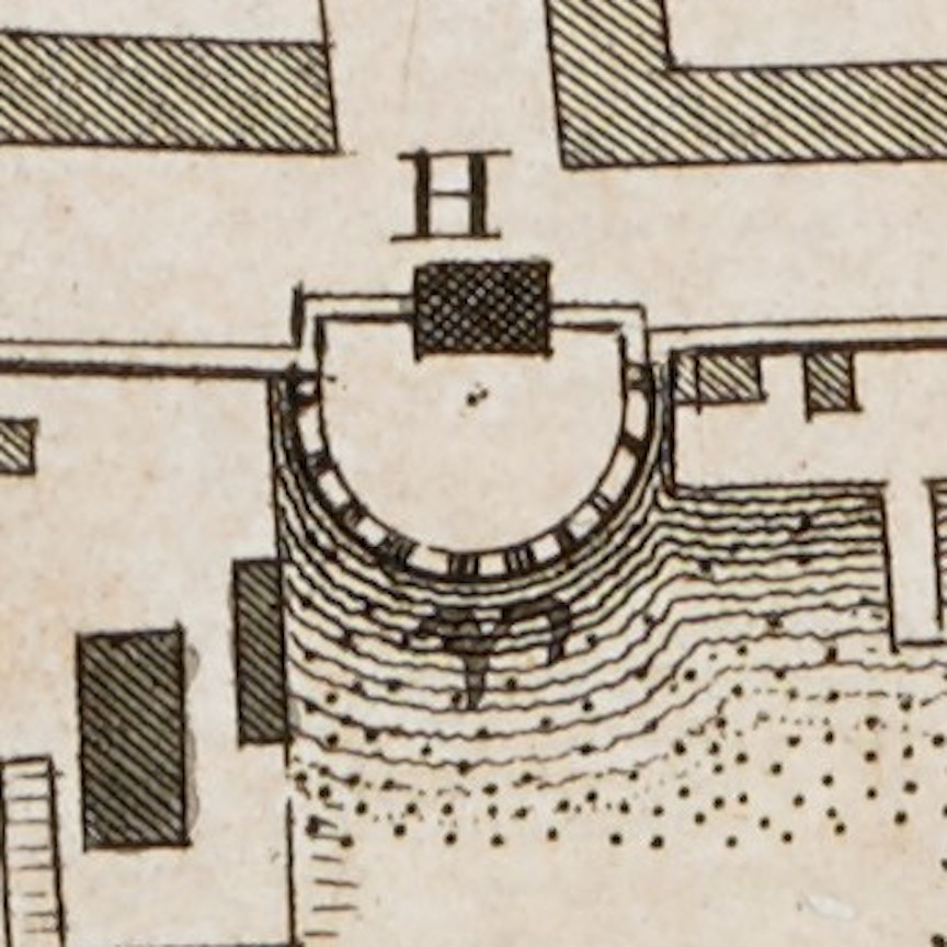
Detail of the Half-Moon Battery from Bishop Roberts’s Ichnography of Charles-Town (1739)
Standing at the east end of Broad Street and overlooking Charleston Harbor, the Half-Moon Battery played a central role in the geography and history of South Carolina’s colonial capital. Despite its significance, generations of historians have been frustrated by the paucity of details relating to its creation. The chronology of its demolition has been known for some time, but the story of its genesis and evolution has eluded previous scholars. The summary presented in today’s program is based on a close study of the sparse references to the battery found in the extant records of the colony’s provincial government, which paid for its construction, maintenance, and destruction. We’ll discuss the social and commercial activities that took place around the Half-Moon in future programs; for the moment, we’ll focus on the rise and fall of the structure itself.
Charleston’s Half-Moon Battery is a unique structure within South Carolina, but its design reflects the traditions of European military architecture in the centuries preceding the founding the Carolina Colony in 1670. In the vocabulary of that discipline, the term “battery” describes a defensive structure that is not fully enclosed like a fort. A battery can stand alone as a detached fortification, or it can form part of a continuous line of defensive works. The term “half-moon battery,” also called a demi-lune or lunette, typically describes a semicircular structure projecting outward from a defensive line.
Numerous examples of circular and semi-circular fortifications were built across Europe during the Medieval and Renaissance Eras, but the popularity of such designs began to fade in the sixteenth century. To defend towns and cities against increasingly-powerful artillery weapons, military engineers moved away from the high walls and rounded turrets that characterized older fortifications and embraced new designs featuring lower defensive walls punctuated by angular projections. Half-moon structures continued to be built during this stylistic transition, however, as seen in the early Spanish Caribbean colonies such as Hispaniola, Puerto Rico, Cuba, and during the early-seventeenth century in the English colonies of Bermuda, Barbados, and others.
Rounded defensive structures became increasingly rare as the science of fortification evolved during the long European wars of the seventeenth century. By the 1690s, when Charleston’s Half-Moon Battery was built, its design would have seemed antiquated and outdated to most military engineers. Nevertheless, this Carolina structure was not an isolated anomaly. Sebastian de Vauban, the leading fortification engineer of late-seventeenth-century Europe, for example, designed a similar half-moon structure, called Fort Lupin, during the late 1680s. Standing on the river banks of Saint-Nazaire-sur-Charente, just south of La Rochelle, the semicircular shape of Fort Lupin might have been familiar to some of the French Huguenot refugees who emigrated to South Carolina during that turbulent decade.
As I mentioned in Episode No. 98, the map of Charleston drawn in 1686 by Huguenot immigrant Jean Boyd depicts a physical mass projecting from the east end of Broad Street that we might describe as having a semi-circular or half-moon shape. This feature, which Boyd did not specifically describe or identify, probably represents a combination of natural and man-made elements; that is, a naturally-occurring scarp of dry land projecting slightly from the shore line that the settlers outlined and augmented with wooden pilings driven into the mud to suit their defensive needs during the late 1670s or early 1680s. Although the demolition of this early half-moon is not recorded in any known documents, the brick semicircle erected in the 1690s occupies the same physical space as the feature depicted in Jean Boyd’s map of 1686. Rather than describing Charleston’s Half-Moon Battery of the 1690s as an example of an outdated fortification design, therefore, it might be more accurate to view its construction as the robust renovation of a pre-existing half-moon revetment built of less-durable materials at the same site more than a decade earlier. . . .
This story continues at Charleston Time Machine.

Leave a comment