fortifications


Over a period of nearly a year and a half in the late 1750s, the people of Charleston watched scores of laborers transform tons of oyster shells into a towering concrete barrier designed to protect the town’s northern boundary from invading enemies. Its construction was deemed vitally important in 1757, but the changing tide of world events convinced local authorities to abandon the tabby Horn Work before it was even finished. This turbulent genesis forms a long-forgotten prelude to the gallant defense of South Carolina’s capital during the American Revolution. 

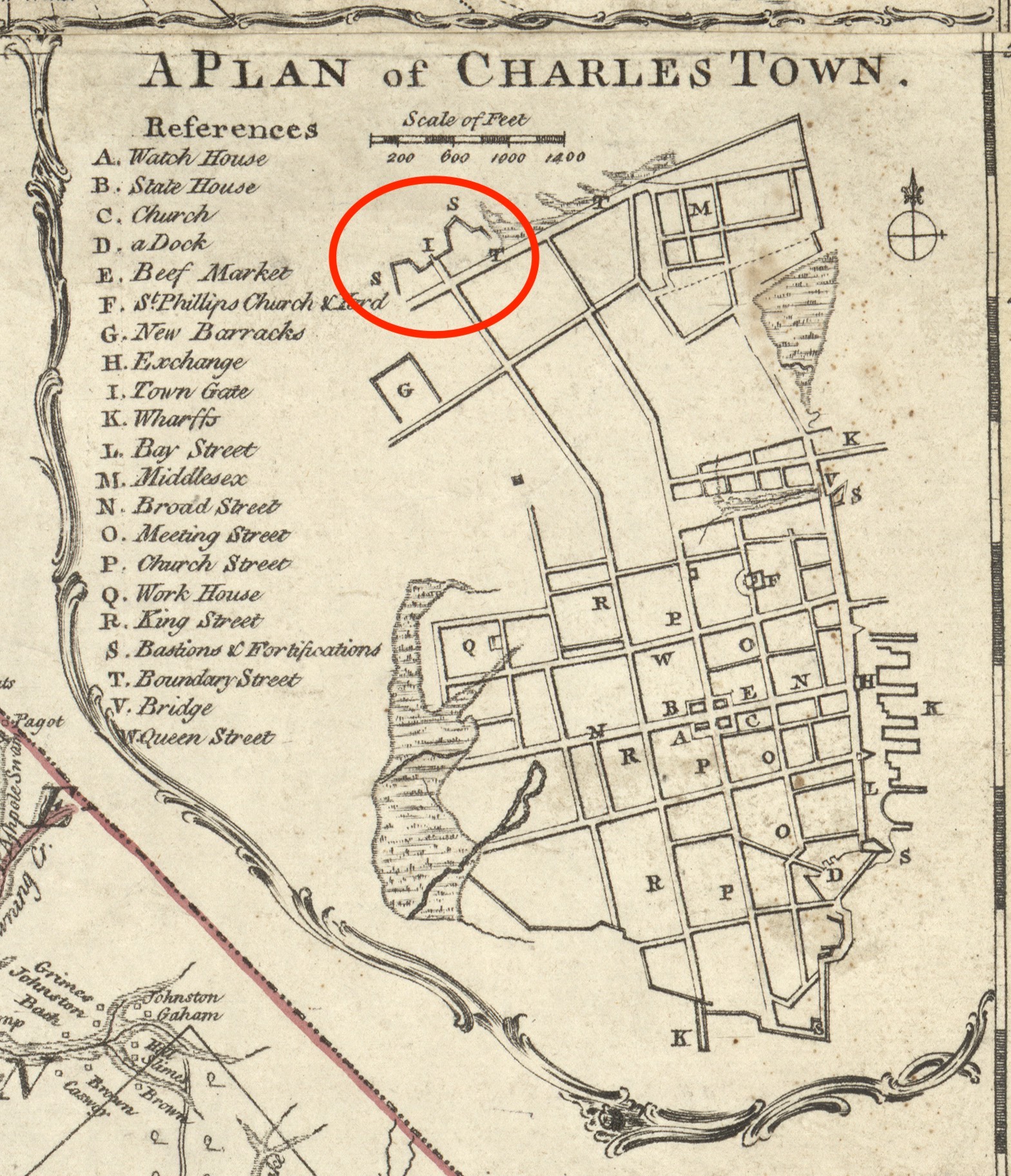
Let’s begin with a brief review of last’s week’s program. In mid-June 1757, during the early stages of the Seven Years’ War with France, Lieutenant Colonel Henry Bouquet came to Charleston with five companies of the British 60th Regiment of Foot (the “Royal Americans”). New defensive fortifications were then underway at White Point, at the town’s southern tip, but Bouquet convinced the South Carolina provincial government to construct a new fortified gate to defend the back or north side of the capital town. Lieutenant Emanuel Hess, an engineer with the 60th Regiment, drew a plan for a horn work composed principally of oyster shell concrete (tabby), with a narrow gate straddling the Broad Path (King Street) leading into Charleston. Governor William Henry Lyttelton approved Hess’s plan in late August, and planning commenced. In mid-October, Lt. Col. Bouquet and Lt. Col. Archibald Montgomery of the newly-arrived 62nd Regiment offered for some of their men to labor on the Horn Work. In early November, the South Carolina Commissioners of Fortifications acquired a rectangular tract of fifteen acres necessary for the new town gate, located just beyond the northern boundary of urban Charleston, and selected three of their own board members to personally superintend the project. The commissioners then directed one hundred soldiers, equipped with a sufficient number of wheelbarrows and spades, to begin digging the foundations of the Horn Work on the morning of Monday, November 14th. 

Beginning Construction

A detail from James Cook's 1773 map of South Carolina, showing urban Charleston.

A detail from James Cook’s 1773 map of South Carolina, showing urban Charleston.

During the initial weeks of labor in late 1757, the superintendents and soldiers apparently cleared the site of trees and obstructions, laid out the lines of the Horn Work on the ground, and then began to dig trenches for its foundations. The surviving records of this work do not mention the presence of Lieutenant Hess, but he likely attended and directed the effort in some capacity. As this preliminary work neared a conclusion in late December, the Commissioners of Fortifications hired Thomas Gordon, a well-known local bricklayer, to “conduct” the tabby work both in Charleston as well as at the new powder magazine in Dorchester, twenty miles away. To facilitate his dual management duties, the commissioners agreed to pay Gordon the large sum of £125 (South Carolina currency) per month on condition that he agreed “to furnish one man in Charles Town & another in Dorchester in his absence & himself to go from one to the other as he shall find it necessary.”

To direct the enslaved laborers who would soon join the hired soldiers, the commissioners employed John Holmes to act as “overseer” or foreman of the work “on the North Line.” In addition, Holmes brought his son and another “white lad” to the site to act as his assistants, brought his own “Negro carpenter,” and included his own “boat & Negroes” in the bargain. For the duration of the Horn Work construction, from late December 1757 to the end of March 1759, Thomas Gordon periodically supervised the tabby work while John Holmes managed the daily labor force, the delivery of materials, and the job site in general.

This story continues at the Charleston Time Machine.


The tabby Horn Work that once guarded the northern approach to Charleston formed the citadel of American resistance during the British siege of 1780, but the story of its construction commenced decades before the Revolution. It arose from prolonged conversations about the best manner of defending the backside of South Carolina’s colonial capital, and was intended to supersede earlier, less remarkable works. Prompted by the outbreak of a new war with France in 1756, local officials and royal engineers bit the bullet and ordered the construction of several new fortifications that would transform the Lowcountry landscape.

Last week I provided an overview of a neglected fortification called the Horn Work that once straddled King Street along the northern edge of colonial Charleston. Having already described the highlights of that structure’s general design, materials, and dimensions, I’d like to segue into a more detailed investigation of its construction in the late 1750s. That era marked the final phase of a long series of fortification projects in urban Charleston that stretched back to the 1670s. Time doesn’t permit a full recital of the several construction campaigns leading up to the 1750s, but a brief synopsis of some of that material will help set the stage, so to speak, for the rise of the Horn Work and help us appreciate its role in our community’s long history. 

This story continues at the Charleston Time Machine.

Have you heard the story of the Horn Work in Marion Square? You know—that mysterious, unobtrusive, lumpy slab of concrete covered with oyster shells standing in the park near King Street? Did you know it’s actually a tiny remnant of a massive fortress that once controlled access to colonial-era Charleston? And it was the city’s first citadel during the American Revolution? The Horn Work is one of Charleston’s biggest secrets hiding in plain sight, and today we’ll review the most salient chapters of its must-read story.

Horn_Work_looking_northeast_2008
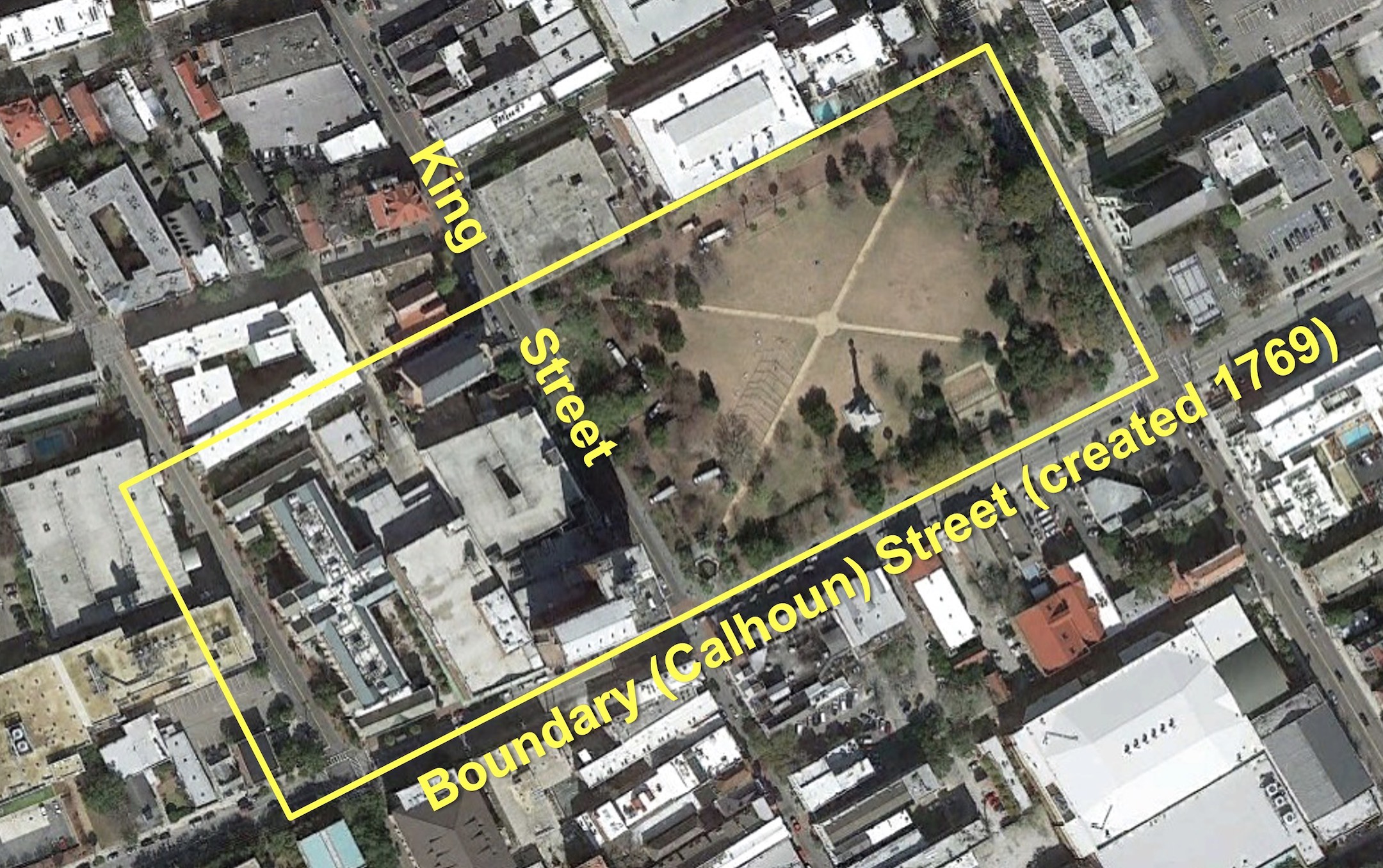
Marion Square is Charleston’s most popular public gathering space, but few visitors recognize one of the city’s most valuable historical treasures within the park. Behind a modest iron railing located approximately 125 feet east of King Street stands a mysterious slab of gray, concrete-like material. It stands approximately six feet high, is nearly ten feet long, and just over two feet wide at its base. A small metal plaque affixed to the railing is inscribed with a few disjointed words: “Remnant of Horn Work. May 1780. Siege of Charleston.” This brief text, installed in 1883, has provided little to inspire the imagination of successive generations of tourists and locals, who often pass the familiar object without a second look.

The homely remnant preserved within that iron fence merits much more attention than it currently receives, however. The brief text on its humble plaque imparts little of the dramatic story behind the massive structure that once dominated the site of Marion Square between 1758 and 1784, and which formed one of the most impressive military posts of the American Revolution. The documentary trail of evidence that illuminates the rise and fall of Charleston’s forgotten Horn Work is fragmentary, incomplete, and scattered across the globe. It’s also a complex narrative, drawn out over a number of decades and embedded within a deep context of international political and military issues.

In short, it’s a difficult story to tell in a brief synopsis. After struggling with this topic for some years, I’m going to attempt to provide an overview of the subject today, followed by a series of more detailed segments in the near future. In my experience, one of the best ways to whittle a complex topic down to a manageable size is to create a series of questions and answers that address the most salient issues. You might have heard me describe the Horn Work in recent years as “Charleston’s tabby fortress.” All of these words, drawn from the vocabulary of eighteenth-century European military engineering and the vernacular architecture of early South Carolina, might not mean anything to readers today, so let’s begin with the basics.

What is a Horn Work?

Horn_work_illustration
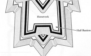
In the vocabulary of military architecture, a “horn work” is a sort of broad fortress with a central gateway situated on the outskirts of a fortified town, the main purpose of which is to defend the approach or path to the settlement from the advance of potential enemies. The name itself is derived from a characteristic feature common to all horn works: a pair of half-bastions projecting outward to the left and to the right of a central wall or “curtain” that includes a gateway straddling the pathway into town. These half-bastions, which provide defenders additional angles to fire at approaching enemies, resemble horns projecting from the sides of an animal’s head. Similarly, if such a fortification included a third bastion in the center of the curtain wall, it would be called a “crown work” because of its resemblance to a monarch’s crown.

A horn work, in the general sense of the term, is a species of military architecture described in scores of fortification textbooks published in seventeenth- and eighteenth-century Europe. It was just one of a number of different types of defensive works that all military engineers of that era were expected to understand. Every species of fortification—like a bastion, a ravelin, or a redout—served a specific function and was suited to a specific situation, and their respective designs were all dictated by a well-established set of geometric rules. In the international landscape of military fortifications, Charleston’s eighteenth-century horn work was not a unique entity. In the long history of South Carolina, however, our Horn Work (for which I’m using initial capitals) was a unique and exceptional structure that merits our attention and appreciation. If nothing else, this structure might have been the only horn work ever built of tabby.

What is Tabby?

Tabby is a type of concrete that was once commonly used in the Lowcountry of early South Carolina and elsewhere. Occasionally spelled “tappy” in historic sources, this building material transformed locally-abundant natural resources into a relatively simple and cheap alternative to traditional masonry construction. Laborers transported sand, ash, broken oyster shells, and powdered lime (derived from burnt oyster shells) to a job site or retrieved them from sources on the spot. After combining those ingredients with water to form a viscous slurry, laborers poured the tabby mixture into a temporary vertical form made of parallel wooden planks connected by wooden dowels. The dimensions of the form varied but were generally in the range of one to three feet in breadth and one to two feet in depth; the length of the form was determined by a number of variables. Once the slurry had dried sufficiently to form a solid mass, the form could be dismantled by sliding the wooden dowels out of the recently-poured slab and removing the wooden planks from each side. By reassembling the same wooden form on top of the cured tabby and repeating the process a number of times, the successive layers of tabby eventually formed a solid vertical wall of any desired height. Surviving examples of tabby work in the South Carolina Lowcountry often include dowel holes and horizontal lines that illustrate such a repeated sequence of actions.

Tabby was often used in early South Carolina to pour slab floors, to construct foundations for wooden buildings, and occasionally to form the walls of entire structures. Its use seems to have been more common around Beaufort and the Port Royal area, however, as fewer examples of historic tabby construction have been found in the vicinity of Charleston. Whatever the reason behind that fact, we know that tabby was considered a novel construction material for fortifications in the Charleston area in 1757. In February of that year, the South Carolina Commissioners of Fortifications, an administrative board created in 1736 and appointed by the governor, ordered “a trial of tabby work” for some repairs to Fort Johnson on James Island. Thomas Gordon, a local bricklayer and tabby expert, then poured a pair of parallel tabby walls to form the inner and outer faces of a broad parapet that was later filled with earth to create a solid mass. The experiment apparently convinced the commissioners that tabby was more permanent that earthen fortifications and cheaper than brickwork, and they hired Gordon to do further work at Fort Johnson and elsewhere. . . .

This story continues at the Charleston Time Machine.

By the middle of the eighteenth century, Charleston was one of the most heavily fortified communities in North America. The town’s urban defenses didn’t appear all at once, however.  They accumulated over multiple decades and successive eras of warfare with our Spanish and French neighbors.  The government campaign to fortify Charleston commenced early in the town’s history, but precisely how early is a bit fuzzy.  Today we’ll focus on the present town’s first few years and ask—how prepared were Charlestonians of the 1680s to defend their little town? The answer just might surprise you.

If you were to travel back in time to visit downtown Charleston at any point between 1704 and 1784, you would find an urban landscape dominated by a network of walls, moats, drawbridges, and cannon that encircled the town—effectively creating what we might call a “walled city.”  Because of ongoing tensions with our Spanish and French neighbors, and Charleston’s relative isolation within the broader landscape of British North America, South Carolina’s early government channeled the modern equivalent of billions of dollars into the construction and maintenance of defensive fortifications that were intended to protect our colonial capital in case of an attack launched by our enemy neighbors.  These fortifications saw little action over the years, and very few of the town’s cannon were ever fired in its defense, but these facts demonstrate that they had fulfilled their purpose.  Charleston’s collective fortifications, which expanded dramatically between 1704 and the 1770s, served as an effective deterrent to anyone contemplating a hostile invasion of one of the richest seaports in colonial North America.  The town’s defensive works were expanded further during our War of Independence in the late 1770s, but they took a significant beating during the protracted and ultimately successful British siege in the spring of 1780.

The colonial community of “Charles Town” was incorporated as “Charleston” in 1783, just after the conclusion of the American Revolution, and the new city and state governments worked together in the post-war years to accomplish a major undertaking—the demilitarization of urban Charleston.  Since that time, visitors have found a civilian city, the landscape of which bears few visible remnants of the colonial-era fortifications.  The early works were effectively demolished and scraped off the face of the earth in the post-Revolutionary decade, after which even locals began to forget about Charleston’s former existence as a “walled city.”  To some, those early defensive works might have seemed like quaint examples of our community’s naïve, colonial infancy.  Few people in the nineteenth century harbored any nostalgic feelings for our early fortifications as the town expanded and became increasingly “modern.”  That sentiment began to change at the turn of the twenty-first century, however, when some people in the community began to realize that the quickening pace of development in urban Charleston was literally churning up physical remnants the city’s militarized past.  Opportunities to study these remnants were at hand and would likely continue in coming years, so a call to arms was sounded.  In 2005, a group of advocates including preservationists, archaeologists, historians, and educators convinced the City of Charleston to create the Mayor’s Walled City Task Force.  Since that time, this volunteer group has worked rather quietly to advocate for the study, preservation, and interpretation of the physical remnants of the colonial-era fortifications that remain below our collective feet in the landscape of urban Charleston.

As a member of this Task Force for the past fourteen years, I have been actively collecting and studying the documentary evidence related the construction and maintenance of defensive fortifications about the peninsular city of Charleston.  This research began with a series of very simple questions: Who paid for these fortifications?  Who was responsible for the construction, maintenance, and demolition of these works?  Are there any surviving records of that activity?  The answers to such questions are both simple and painfully complicated.  The provincial government of early South Carolina ordered and paid for the fortifications.  The government, principally the South Carolina Commons House of Assembly, appointed and hired agents to superintend the construction and maintenance of various fortifications over a period of about a century.  These agents periodically reported their activities and submitted invoices to the government, and the legislature periodically surveyed the fortifications as the treat of foreign invasion waxed and waned.  Over the years, I have made a systematic sweep through the surviving records of South Carolina’s colonial government, now housed at our state’s Department of Archives and History in Columbia, and collected more than two thousand pages of single-spaced notes relating to the fortifications of urban Charleston.  In short, there is very robust paper trail for the government’s efforts to defend its colonial capital, but the documentary evidence of this activity is incomplete and inconsistent.  Some projects and eras, such as the works constructed during the mid-1750s, are remarkably well documented, while the paper trail for others—especially the earliest fortifications—is practically non-existent.  To address these documentary shortcomings, and to better understand the context in which these fortifications were built, I’ve had to spend a lot of time studying the history of European military architecture and the international political climate that motivated the government of early South Carolina to expend precious resources on the defense of its capital.

Today’s program represents the beginning of a series of essays in which I’ll attempt to distill and narrate the century-long story of the urban fortifications of colonial Charleston.  After years of collecting information and trying to interpret the data, it’s time to start committing my conclusions to (virtual) paper and share them with the public.  I’ll begin this effort today by focusing specifically on the early 1680s, and in the coming months I’ll periodically roll out additional essays with lots of illustrations.  A few years from now, I’ll gather these essays together and publish them as a proper book.  If additional evidence—documentary or physical—rises to the surface during this process, I’ll have a chance to revise my conclusions and improve the story before handing this project over to the next generation of historians.  Ok, enough of the prelude, let’s get to the main event. . . .

This story continues at the Charleston Time Machine.

For the first century of its existence, the urban landscape of Charleston was dominated by an evolving ring of fortifications designed to protect the city against potential invasion by Spanish, French, and later British forces.  Our provincial legislature repeatedly devoted large sums of tax revenue for the construction and repair of walls, moats, bastions, and related works, resulting in what was undoubtedly the largest public works program in colonial South Carolina.  Despite the impressive scale of this work, however, Charleston’s modern streetscape reveals scarcely any physical trace of those early fortifications.  If the city once bristled with cannon, walls, moats, and drawbridges, how and when were such features scoured from the historical landscape?

Many of the details concerning the demilitarization of urban Charleston can be found in the public records created in the immediate aftermath of the American Revolutionary War.  Although incomplete, these records provide sufficient information to construct a robust outline of the decisions, issues, and events that took place between 1783 and 1789 and resulted in a dramatic alteration of Charleston’s urban landscape.  During this brief period, both state and city governments worked in tandem to survey, dismantle, and sell the accumulated urban fortifications.  The evidence of this cautious transition from defensive stronghold to peaceful commercial port provides two principal lessons for modern historians to consider.  On the local scale, the demolition of Charleston’s urban fortifications produced some of the most valuable documentary evidence of their dimensions, composition, and location.  On the national scale, this story presents a local example of the larger American struggle to chart a new civic course in the tumultuous environment of the Age of Revolution.

This story continues at the Charleston Time Machine.

This map of Charleston, surveyed in 1788 and published in 1790, was made shortly after the demilitarization of the city. Craven Bastion, located at the foot of the creek that would soon become Market Street, is the sole remaining fortification depicted on this map.

« Previous PageNext Page »