fortifications


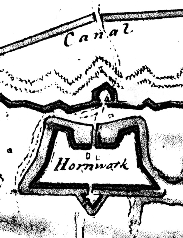
During a building demolition project six years ago, the 1940 bronze plaque marking the approximate location of Carteret Bastion mysteriously disappeared. The plaque and the bank building being demolished were then located on the southeast corner of Meeting and Cumberland Streets in downtown Charleston. For many years, that site was thought to have been occupied by Carteret Bastion, one of the corner bastions of the earliest phase of the “walled city,” which stood from late 1703 to the early 1730s. When the historical plaque was first minted in 1940, however, it was placed at the northeast corner of that intersection, and moved to the southeast corner in 1970. Since the plaque disappeared around 2002, Katherine Saunders and I have enjoyed a number of conversations about the evidence for the “real” location of Carteret Bastion, pondering which corner might be appropriate for a newly-cast marker. When the 1940 plaque resurfaced this summer, we were in agreement that the northwest corner of Meeting Street and Horlbeck Alley was the most appropriate home, and we’re pleased to see that has now been re-mounted there.

Our reasoning behind this decision? First, we know that Meeting Street, between Tradd and Cumberland Streets, was an active thoroughfare in Charleston during the period 1703–1730, when we know Carteret Bastion was standing. Thus the bastion must have been located on the west side of the street, approximately at the present site of Horlbeck Alley. Second, some archaeological investigation has been performed at the southeast and southwest corners of that intersection, but no evidence of a wall or bastion was located at either site. Third, anecdotal evidence supplied by construction workers digging in the early 1980s at the northeast corner of the intersection, the original location of the plaque, suggests that no traces of fortifications rest at that site. In short, the northwest corner is of Meeting and Horlbeck Alley may not mark the precise location of Carteret Bastion (named for Sir John Carteret, Earl of Granville, who was one of the Lord Proprietors of Carolina at the time the wall was erected in 1703-4), but in the modern streetscape of Charleston it represents the most appropriate site to commemorate this historical feature. You can read more about this story in Robert Behre’s article “Bastion marker resurfaces in new locale” in today’s edition of the Charleston Post and Courier.

Dr. Nic Butler digging at South Adger\'s Wharf in January 2008 At noon this Friday, May 9th 2008, Dr. Nic Butler will be the featured guest on Walter Edgar’s Journal, a weekly radio program broadcast on South Carolina ETV Radio. Dr. Butler is Special Collections Manager at the Charleston County Public Library and historian for the Mayor’s Walled City Task Force. The topic of Friday’s conversation, recorded on February 18th, is the recent archaeology at South Adger’s Wharf and Charleston’s colonial fortifications in general. We’ll hear some insight into the formation of the Mayor’s Walled City Task Force and the planning and research that preceded the dig, as well as a summary of our findings and some discussion of the prospects for future archaeology of Charleston’s colonial walls. In short, it will be an inspiring conversation about one of the most unique and exciting aspects of this city’s history.

If you miss Friday’s broadcast, don’t panic! After a delay of about a week you’ll be able to download the free podcast version of the program from Dr. Edgar’s web page or from iTunes. Enjoy!

One of the most “popular” and yet misunderstood visual images of colonial Charleston is the map commonly known as the “Crisp Map.” Since it’s the only published map that shows the first walls surrounding the city, many books and articles use this image as a principal illustration of life in early colonial Charleston. There’s an important catch, however, that many readers are not aware of. The image of the Crisp Map that is commonly found in books, articles, and even the official City of Charleston tour guide manual, is a flawed nineteenth-century fake.

James Akin’s 1809 misleading “copy” of the Crisp Map

Engraved by James Akin of Philadelphia and published in David Ramsay’s History of South Carolina in 1809, this map (seen here to the right) measures approximately 9 by 11.5 inches and bears the title “A Plan of Charles Town from a survey of Edwd. Crisp in 1704.” For nearly two hundred years now readers have admired this map and assumed Edward Crisp created it from his own survey of the town in 1704, but that’s just not true.

The “Crisp Map” is actually a large-format (82 by 99 cm), multi-image map that was published by Edward Crisp in London in 1711. Actually, it was published without a date, but historians have studied the names and features on the map and determined beyond doubt that it was published in 1711 (certainly not 1704). As you can see in the image below, the map bears a long title: “A Compleat Description of the Province of Carolina in 3 Parts. 1st. The Improved Part from the Surveys of Maurice Mathews & Mr. John Love. 2ly. The West Part by Capt. Tho. Nairn. 3ly: A Chart of the Coast from Virginia to Cape Florida. Published by Edwd. Crisp.” Towards the middle of the map is a cartouche with a dedication to the Lords Proprietors of Carolina, as well as the following two statements: “Sold at the Carolina Coffee House in Birchen [sic, Birchin] Lane London,” and “Engraven by Iohn Harris in Bulls-head Court Newgate Street London.” Note that Edward Crisp was the publisher, not the surveyor, of this map. In his definitive book The Southeast in Early Maps, William P. Cumming notes that Crisp identified himself in London in a 1715 letter to the Lords Proprietors of Carolina as a “Merchant trading to Carolina.” Although Crisp received a land grant in Carolina as a reward for publishing this map, it appears that he never set foot in this colony.

Viewing the image of full Crisp Map above, you’ll notice that the image of Charleston (Charles Town) is just one of several small insets, and has a separate title: “A Plan of the Town & Harbour of Charles-Town.”  I’ll leave it up to you, gentle readers, to examine the minute differences between the real Crisp Map of 1711 and the inauthentic 1809 version. Yes, there are several differences between the two. For instance, Akin’s version includes “White Point” and “First Rice Patch in Carolina,” neither of which are present in the 1711 map. For your viewing ease, I’ve cropped the Charleston inset and placed it here to the right. The 1711 edition of this map is actually quite rare today, and the images here come from the hand-colored copy held at the U.S. Library of Congress. If you’d like to read more about this map and/or acquire a copy for yourself, follow this link: http://hdl.loc.gov/loc.gmd/g3870.ct001123.

As far as the fortifications of early colonial Charleston are concerned, the authentic 1711 version of the Crisp Map is a very important source of information for understanding the nature, location, and identity of the town’s various urban defenses at that moment. In future postings we’ll delve into the individual components, such as the various bastions, redans, and walls.

1781_horn_work.jpgOne of the most common questions that I’m asked at “Walled City” events is “where can I see part of the fortifications that once surrounded Charleston?” Almost equally as common is the question “what’s the story behind that mound of oyster shells standing in Marion Square?” In an attempt to answer both of these questions at one time, I’m offering a program later this month titled “The Horn Work: Charleston’s Tabby Fortress, 1759-1784.” The program will be presented at the Charleston County Public Library on Monday, April 28th at 6:00 p.m., and it’s free and open to the public. We’ll take a look at some historic illustrations of the old Horn Work (including the 1781 map shown above), and try to understand the lone remnant standing in Marion Square as a small part of what was once a large fortress mounting eighteen cannon and surrounded by a moat thirty feet wide. tabby_remnant_in_marion_square.jpgHow did the “Horn Work” get its name, and when was it built? When was it demolished, and why does one small piece survive above ground? Has anyone ever searched below ground to find further evidence of its walls? For the answers to these questions, plus many more fascinating details and images, please join the Mayor’s Walled City Task Force at the Charleston County Public Library on the 28th. For more details and a printable flyer (a PDF file), please see our Upcoming Events page. I hope to see you there!

On 30 January 2008 the Mayor’s Walled City Task Force presented an illustrated overview of the recent archaeology at South Adger’s Wharf. Well over a hundred people came to the Charleston County Public Library’s auditorium to hear about the dig from several of the participants.

katherine_saunders.jpgTo open the program, Task Force co-chair Katherine Saunders took a few minutes to acknowledge the sponsors who made the archaeology possible and the volunteers who contributed so much to its success. Without the assistance and enthusiasm of these dozens of people, this long-anticipated project might never have come to fruition.

nic_butler.jpgNext, I presented an illustrated historical overview of the redan and Lower Market that once stood at the east end of Tradd Street. As you can see in the photo here, I also mentioned the building known as the Court Room and Exchange that stood just within the redan between 1723 and 1740. We were hoping to find the foundations building, but our dig site turned out to be about twenty feet north of that structure.

eric_poplin.jpgArchaeologist Dr. Eric Poplin provided a great illustrated summary of the dig, with special emphasis on reading the layers of soil that we encountered. In the brief period of time since the dig concluded, Dr. Poplin had already prepared some fascinating illustrations of the stratigraphy. His color slides, and the accompanying posters created by the History Workshop, will be included in the final published report of the South Adger’s Wharf dig.

martha_zierden.jpgCharleston Museum curator of archaeology Martha Zierden took the stage to discuss the collection and curation of artifacts from the recent dig. In addition to her slides and narration, Zierden and her colleague Ron Anthony brought a large number of pottery sherds, bone fragments, and other materials collected from the site. At the conclusion of the program, audience members were invited to crowd around the display table of artifacts and chat with the archaeologists.

peter_mcgee.jpgTo conclude the program, Task Force co-chair Peter McGee extended his thanks to everyone involved for their support and hard work, and to the audience for their attention and encouragement. The recent South Adger’s Wharf dig, which uncovered about one-third of the Tradd Street redan, was so successful, Mr. McGee opined, that he hopes the Mayor’s Walled City Task Force will be able to continue its momentum in the coming year and gather support for another dig to uncover the other two-thirds of that redan. I second that proposition!

Those of you who were unable to attend this program will be pleased to know that I am currently working on a multimedia encapsulation of this program. The finished product will be made available through this website, most likely as a podcast that can be streamed over the internet or downloaded. Stay tuned for further information!

« Previous PageNext Page »