By the middle of the eighteenth century, Charleston was one of the most heavily fortified communities in North America. The town’s urban defenses didn’t appear all at once, however. They accumulated over multiple decades and successive eras of warfare with our Spanish and French neighbors. The government campaign to fortify Charleston commenced early in the town’s history, but precisely how early is a bit fuzzy. Today we’ll focus on the present town’s first few years and ask—how prepared were Charlestonians of the 1680s to defend their little town? The answer just might surprise you.
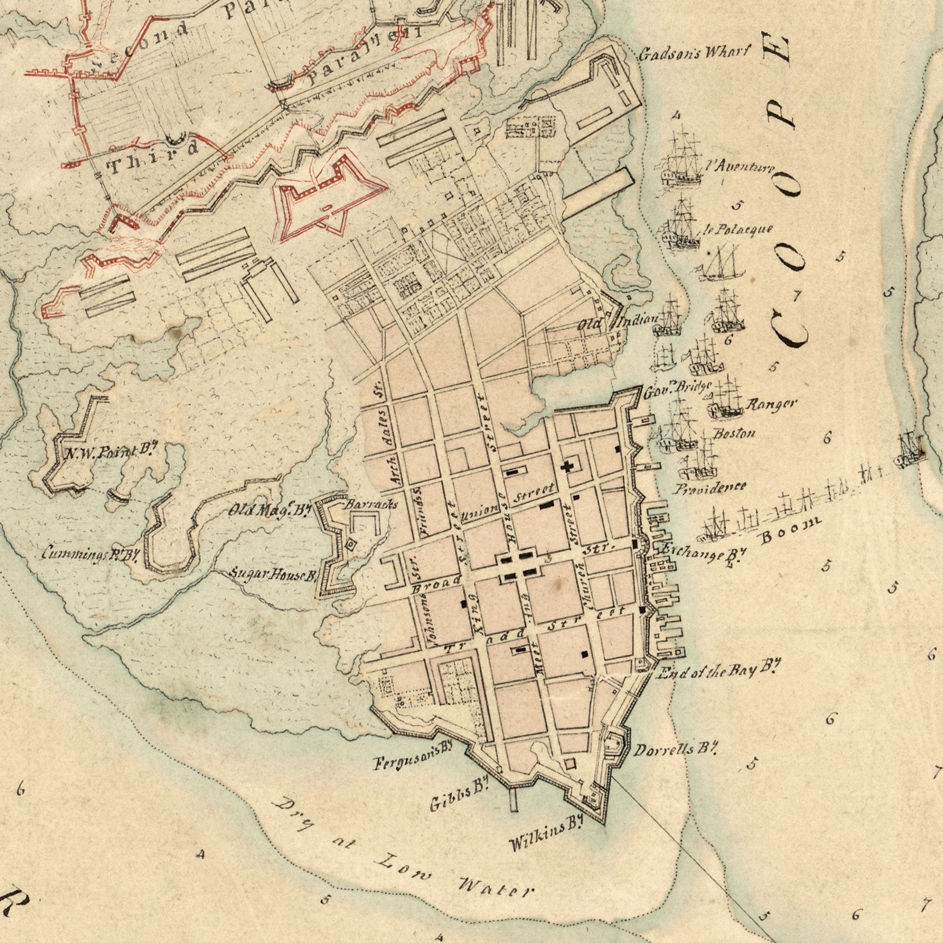
If you were to travel back in time to visit downtown Charleston at any point between 1704 and 1784, you would find an urban landscape dominated by a network of walls, moats, drawbridges, and cannon that encircled the town—effectively creating what we might call a “walled city.” Because of ongoing tensions with our Spanish and French neighbors, and Charleston’s relative isolation within the broader landscape of British North America, South Carolina’s early government channeled the modern equivalent of billions of dollars into the construction and maintenance of defensive fortifications that were intended to protect our colonial capital in case of an attack launched by our enemy neighbors. These fortifications saw little action over the years, and very few of the town’s cannon were ever fired in its defense, but these facts demonstrate that they had fulfilled their purpose. Charleston’s collective fortifications, which expanded dramatically between 1704 and the 1770s, served as an effective deterrent to anyone contemplating a hostile invasion of one of the richest seaports in colonial North America. The town’s defensive works were expanded further during our War of Independence in the late 1770s, but they took a significant beating during the protracted and ultimately successful British siege in the spring of 1780.
The colonial community of “Charles Town” was incorporated as “Charleston” in 1783, just after the conclusion of the American Revolution, and the new city and state governments worked together in the post-war years to accomplish a major undertaking—the demilitarization of urban Charleston. Since that time, visitors have found a civilian city, the landscape of which bears few visible remnants of the colonial-era fortifications. The early works were effectively demolished and scraped off the face of the earth in the post-Revolutionary decade, after which even locals began to forget about Charleston’s former existence as a “walled city.” To some, those early defensive works might have seemed like quaint examples of our community’s naïve, colonial infancy. Few people in the nineteenth century harbored any nostalgic feelings for our early fortifications as the town expanded and became increasingly “modern.” That sentiment began to change at the turn of the twenty-first century, however, when some people in the community began to realize that the quickening pace of development in urban Charleston was literally churning up physical remnants the city’s militarized past. Opportunities to study these remnants were at hand and would likely continue in coming years, so a call to arms was sounded. In 2005, a group of advocates including preservationists, archaeologists, historians, and educators convinced the City of Charleston to create the Mayor’s Walled City Task Force. Since that time, this volunteer group has worked rather quietly to advocate for the study, preservation, and interpretation of the physical remnants of the colonial-era fortifications that remain below our collective feet in the landscape of urban Charleston.
As a member of this Task Force for the past fourteen years, I have been actively collecting and studying the documentary evidence related the construction and maintenance of defensive fortifications about the peninsular city of Charleston. This research began with a series of very simple questions: Who paid for these fortifications? Who was responsible for the construction, maintenance, and demolition of these works? Are there any surviving records of that activity? The answers to such questions are both simple and painfully complicated. The provincial government of early South Carolina ordered and paid for the fortifications. The government, principally the South Carolina Commons House of Assembly, appointed and hired agents to superintend the construction and maintenance of various fortifications over a period of about a century. These agents periodically reported their activities and submitted invoices to the government, and the legislature periodically surveyed the fortifications as the treat of foreign invasion waxed and waned. Over the years, I have made a systematic sweep through the surviving records of South Carolina’s colonial government, now housed at our state’s Department of Archives and History in Columbia, and collected more than two thousand pages of single-spaced notes relating to the fortifications of urban Charleston. In short, there is very robust paper trail for the government’s efforts to defend its colonial capital, but the documentary evidence of this activity is incomplete and inconsistent. Some projects and eras, such as the works constructed during the mid-1750s, are remarkably well documented, while the paper trail for others—especially the earliest fortifications—is practically non-existent. To address these documentary shortcomings, and to better understand the context in which these fortifications were built, I’ve had to spend a lot of time studying the history of European military architecture and the international political climate that motivated the government of early South Carolina to expend precious resources on the defense of its capital.
Today’s program represents the beginning of a series of essays in which I’ll attempt to distill and narrate the century-long story of the urban fortifications of colonial Charleston. After years of collecting information and trying to interpret the data, it’s time to start committing my conclusions to (virtual) paper and share them with the public. I’ll begin this effort today by focusing specifically on the early 1680s, and in the coming months I’ll periodically roll out additional essays with lots of illustrations. A few years from now, I’ll gather these essays together and publish them as a proper book. If additional evidence—documentary or physical—rises to the surface during this process, I’ll have a chance to revise my conclusions and improve the story before handing this project over to the next generation of historians. Ok, enough of the prelude, let’s get to the main event. . . .
This story continues at the Charleston Time Machine.


 Subscribe via email