archaeology


Most of Charleston has been fascinated by the recent discovery of a previously unknown graveyard at the site of the Gaillard Center renovation project. In February and March of this year, a team led by Dr. Eric Poplin, senior archaeologist with Brockington and Associates, unearthed the remains of

Dr. Poplin and the Brockington team

Dr. Poplin and the Brockington team

37 individuals who were laid to rest at that site, on the east side of Anson Street, sometime between 1680 and 1740. Many among the community are curious to know more about these people: Who are they? How and when did they die? Why were they interred at this spot–well outside of the “walled city”? Wouldn’t we all like to know the answers to these questions?

Well, now’s your chance to hear the latest conclusions from the experts. The Charleston County Public Library invites the public to a free program on Wednesday, May 1st, 2013, at 6 p.m. CCPL’s public historian, Dr. Nic Butler, will provide a brief overview of this early history of the site on which the Gaillard Center now stands, and then introduce the featured guest, Dr. Eric Poplin, who will describe the discovery and excavation of the bodies. Using photographs and maps, Dr. Poplin will discuss the clues discovered in the graves that inform his conclusions about the dates of the burials and the status of the individuals interred there. We may not have all the answers at this early date in the research process, but we hope to give the public a better understanding of this fascinating discovery in Charleston’s own backyard. So please join us for

“Graves at the Gaillard Center: The Rediscovery of a Forgotten Resting Place”

Charleston County Public Library Auditorium

68 Calhoun Street

Wednesday, May 1st 2013

6:00 p.m.

1739 View of Craven's Bastion

1739 View of Craven’s Bastion

Craven’s Bastion was built in the early 1700s and formed the northeast corner of the colonial “walled city” of Charleston. During the war with Spain in the 174os, scores of Spanish prisoners were housed here in miserable conditions. During the British occupation of the city in 1780–82, Craven’s Bastion was used as a civilian jail and headquarters of the “town police.” Like the rest of Charleston’s colonial fortifications, the bastion was demolished after the American Revolution, however, and the remnants of its brick walls are now hidden under East Bay Street and the steps of the U.S. Custom House (built 1853–79). Using clues from colonial-era documents and new archaeological technology, it might it be possible to pinpoint its precise location and dimensions. Please join Dr. Nic Butler for an illustrated overview of this important Charleston landmark.

“A Brief History of Craven’s Bastion, 1703–1789”

Wednesday, February 27, 2013 at 6:30 p.m.

2nd Floor Classroom,

Charleston County Public Library

68 Calhoun Street

Site of the dig on 23 January 2013

Site of the dig on 23 January 2013

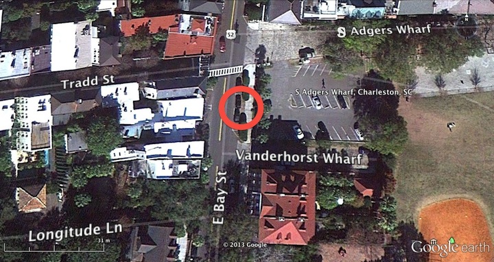
On Wednesday, January 23rd, a section of colonial Charleston’s waterfront “curtain line” or “wharf wall” was exposed, measured, and mapped for the first time. This happy event took place during a one-day dig sponsored by the Charleston Water System, a Task Force member who had recently conducted utility work in the vicinity, and generously offered to supply labor and equipment for a brief exploratory dig. The site chosen was a small patch of asphalt, grass, and concrete sidewalk on the east side of East Bay Street, just a few yards south of South Adgers Wharf. Excavations at that site in 2008 and 2009 revealed the remains of the redan or salient angle that once stood at the east end of Tradd Street, but neither of those digs extended sufficiently westward to locate the brick curtain line that tied into the redan.

Looking northeast at the dig site on East Bay Street

Looking northeast at the dig site on East Bay Street

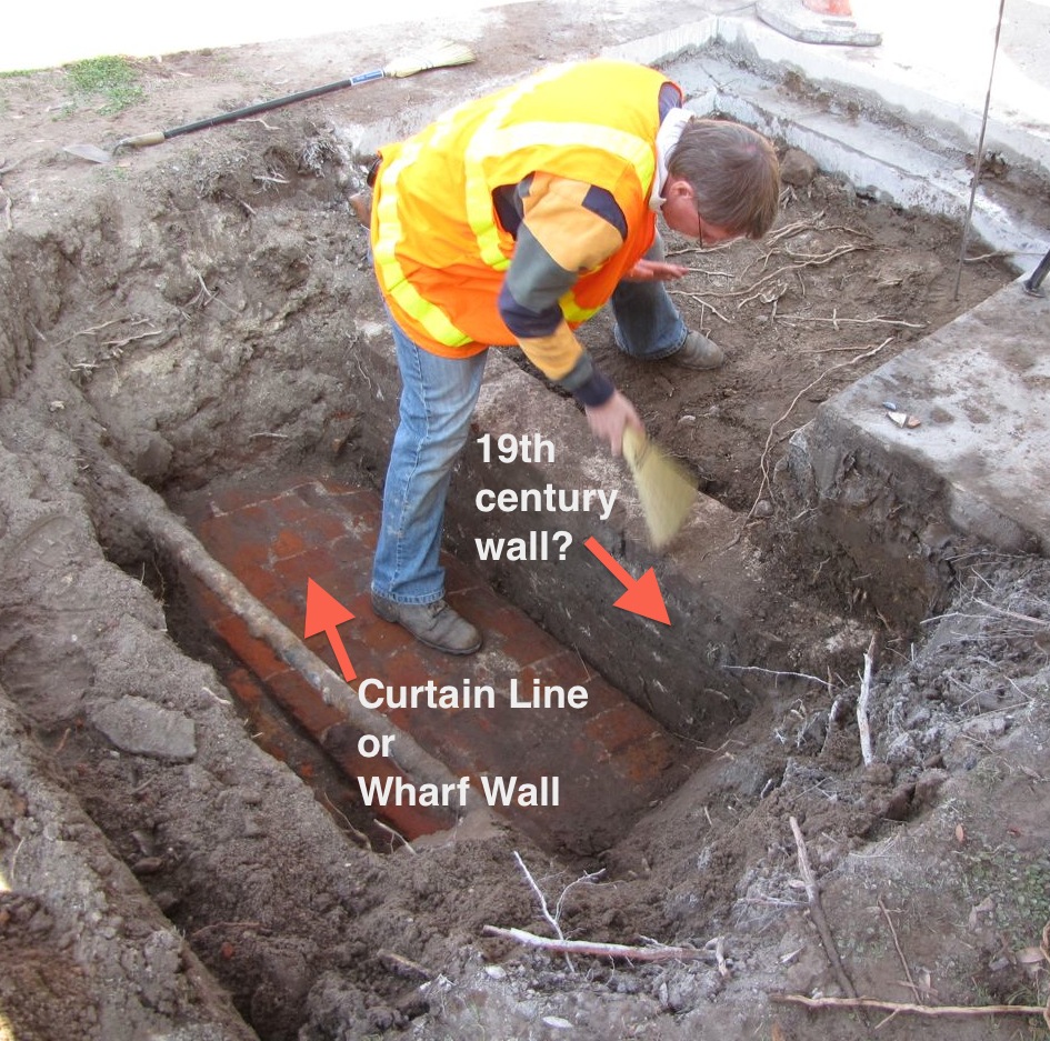
Early Wednesday morning, a crew of streetscape specialists from Anson Construction cut out a rectangular slab of asphalt from the east parking lane in East Bay Street. Using a backhoe to excavate the earth below the paving, the crew found no sign of the old wall. Moving farther to the east, the crew removed a square section of the concrete sidewalk and found a curious brick wall, only one brick thick, running parallel to the street and sidewalk approximately one foot below the modern grade. The size and color of these bricks suggest a nineteenth-century vintage, but the purpose or origin of this wall is currently unknown. Finally, the Anson crew used the backhoe to remove the narrow patch of grass and earth located between the street curb and the sidewalk. Approximately 1.5 feet below the aforementioned wall, we encountered the top surface of the old brick curtain line.

Dr. Eric Poplin preps the walls prior to mapping their location

Dr. Eric Poplin preps the walls prior to mapping their location

This colonial-era wall, initiated by an act of the South Carolina legislature in 1694, runs parallel to modern East Bay Street, and in this specific site is literally sandwiched between the street curb and the sidewalk. It once stood approximately six feet above the street, but after being demolished down to street level in 1785, it’s now more than two feet below grade. The present top surface is approximately 26.5 inches wide, which is roughly half the width of the nearby redan walls excavated in 2008 and 2009. The bright red and orange bricks and the bright white mortar are an exact match to the colonial fortification materials found at the Tradd Street Redan, the Half-Moon Battery, and Granville’s Bastion.

The wall roughly follows the north-south axis along East Bay Street

The wall roughly follows the north-south axis along East Bay Street

Once the top of the old curtain wall was located and its identity confirmed, the exposed portion was measured, photographed, and mapped by archaeologists and Task Force members Martha Zierden (of the Charleston Museum) and Eric Poplin (of Brockington and Associates). Immediately afterward, the wall was covered with earth and the sidewalk and street repaved. The wall is now hidden below the surface again for its own protection, but the data gathered during this brief exploration will contribute greatly to the ongoing effort to map the remnants of Charleston’s colonial fortifications with great precision. In future, a few more similarly brief, shallow digs along the east side of East Bay Street would allow us to positively locate the entire length of old “wharf wall,” which once stretched approximately 2,566 feet along our waterfront.

The Task Force extends its thanks to Charleston Water System for its generosity and to the crew from Anson Construction for their enthusiasm. We eagerly look forward to future collaborations!

1739 view of the Half-Moon Battery by Bishop Roberts

1739 view of the Half-Moon Battery by Bishop Roberts

The brick Half-Moon Battery below Charleston’s Old Exchange Building is the most visible and intact vestige of the city’s colonial fortifications. Constructed more than 300 years ago, it hosted some of the most colorful and gruesome episodes in Charleston’s history, and still holds a few mysteries to be solved. Want to learn more about this important remnant of Charleston’s colonial past? Please join us for an illustrated program entitled:

“The Half-Moon Battery: A Brief History of a Charleston Landmark”

  • Wednesday, January 23d at 6:30 p.m., Charleston County Public Library, 68 Calhoun Street, 2nd Floor Classroom.
Granvill's Bastion in 1739

Granville’s Bastion as it appeared in 1739

Commissioned in 1696 and dismantled in 1785, Granville’s Bastion was Charleston’s first brick “fortress” and the principal defensive work along the Cooper River waterfront. Here twelve cannon guarded the southeast corner of the town, overlooking a small beach where royal governors and visiting dignitaries were received with pomp and ceremony. Only its foundations remain today, under the present Missroon House, but the surviving materials provide sufficient clues to facilitate a conjectural reconstruction. Please join historian Nic Butler on November 28th for an illustrated review of the history of Granville’s Bastion, and learn how new technology can be used to render a 3D model of this once-formidable structure.

Granville’s Bastion: Charleston’s First Brick Fortress

Place: Charleston County Public Library, 2nd Floor Classroom

Time: Wednesday, November 28th 2012, at 6:30 p.m.

« Previous PageNext Page »