archaeology


Everyone is familiar with Charleston’s famous Battery, the stone and concrete sea wall and promenade that wraps around White Point at the southern tip of the peninsula. In fact, the Battery is our city’s most popular tourist destination, drawing several million visitors every year. Few people know, however, that this picturesque landmark was not the first wall the protect White Point from the daily inundation of the tides. Beginning in the spring of 1768 and concluding the autumn of 1769, the General Assembly of South Carolina funded the construction of a half-mile long wall around this same location, using Bermuda stone, bricks, and palmetto logs. Although it has been almost entirely forgotten, significant portions of this late-colonial-era wall may still exist under White Point Garden. In the coming weeks, the Mayor’s Walled City Task Force will endeavor to raise awareness of the this forgotten wall by way of blog posts, public programs, and even a brief archaeological dig.

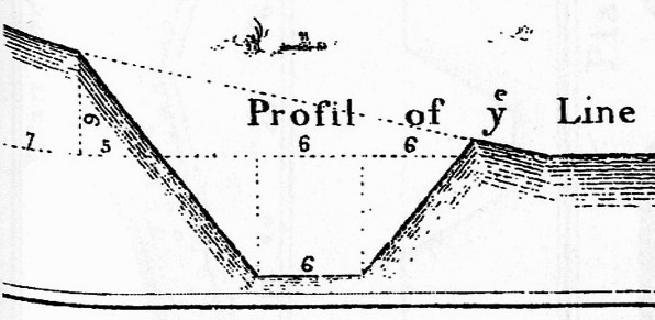
The sea wall in question, which didn’t really have a proper name, commenced in 1768 at Granville’s Bastion (now under the Missroon House at 40 East Bay Street) and extended southward past Lyttelton Bastion, turned westwardly around Broughton’s Battery, and ended at Lamboll’s Bridge (a large wharf just west of the south end of King Street). Its primary purpose was to protect the above-mentioned fortifications from the “violence of the seas,” and it replaced the earthen ramparts constructed (at great expense) for that purpose in the late 1750s under engineer William De Brahm. According to the design specifications, which survive in the manuscript “Journal of the Commissioners of Fortifications, 1755-1770” at SCDAH, the brick wall stood at least five feet above ground on a foundation of Bermuda stones. Split palmetto logs were affixed to the outer face of the wall as a sacrificial buffer against tidal forces. The contract for the brickwork was won by the firm of Timothy Crosby and Anthony Toomer, while Hercules Hall was the lowest bidder for the carpentry contract.

The red line indicates the path of the 1768-1769 sea wall around Charleston's White Point

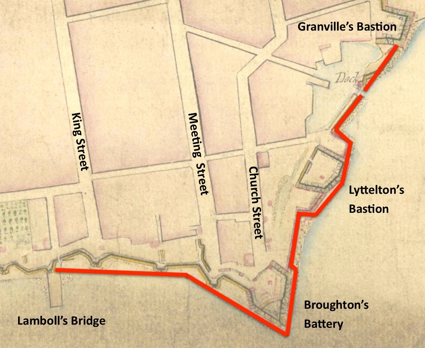
The red line indicates the path of the 1768-1769 sea wall around Charleston’s White Point

As discussed in previous postings on this blog, the various colonial-era fortifications situated around White Point were dismantled shortly after the American Revolution, and the waterfront property on which they had stood was subdivided and sold at auction. When the City of Charleston began planning the southward extension of East Bay Street in 1785, the proposed route extended from Granville’s Bastion toward the former site of Broughton’s Battery, but passing in front (eastward) of the “old” brick sea wall. In the course of the private development along this site, in conjunction with the city’s creation of what is now called “East Battery Street,” the northeastern half of the our late-colonial sea wall was probably obliterated. In contrast to this loss, however, the southwestern half of the old wall appears on several post-Revolutionary plats of White Point and South Battery, and, despite private development in this area in the late 1700s, significant portions of this wall may survive under the grass of White Point Garden, the seven-acre park developed between the late 1830s and the early 1850s.

In the coming weeks there will be several opportunities to learn more about this long-forgotten sea wall, so stay tuned to this blog for updates. For the moment, however, I encourage you to mark your calendar for an upcoming free public lecture, titled:

“Charleston’s First Battery Sea Wall, 1768-1769”

Tuesday, January 27th at 6 p.m.

Charleston Public Library Auditorium, 68 Calhoun Street, 29401.

Detail from John Muller's 1757 fortification treatise, The Attac and Defense of Fortified Places

Detail from a profile of an earthen entrenchment and ditch, from John Muller’s 1757 fortification treatise, The Attac and Defense of Fortified Places

Earthen walls and moats (or ditches) go hand-in-hand in the history of military architecture, and the same was true in colonial Charleston. At this month’s Walled City lecture, I’ll discuss the evidence—both documentary and physical—of the first system of earthen walls and the associated moat that protected the north, west, and south sides of Charleston from late 1703 to ca. 1734. Very little information about these walls survives, but we can attempt to fill in the blanks in our knowledge by taking lessons from the fortification textbooks of the late seventeenth and early eighteenth centuries. Such textbooks, including those published by John Muller in the 1740s and 1750s, provide instructions for laying out all sorts of fortifications, and provide very useful formulas and tables for calculating the height, breadth, and slope of walls, as well as the depth and breath of moats. Armed with this knowledge of eighteenth-century “best practices” in fortification construction, we can attempt to postulate the scale, and predict the location, of Charleston’s early earthen walls and the first moat that surrounded the town.

If you’re envisioning towering, forbidding walls, you’ll be disappointed to learn that our walls were probably in the range of seven to ten feet high, and perhaps only twice that size in breath. There is a tendency in Charleston to exaggerate the size of these walls when describing them to visitors, but the truth is we desperately need additional evidence in order to make more accurate estimates. Even a small scrap of physical evidence would be amazingly useful, but unfortunately the town’s early walls were reduced to a mere stain in the ground nearly three hundred years ago. Perhaps future archaeology will provide much-needed clues, but in the meantime we’ll have to make the most of the available data and use our historically-informed imaginations. If you’d like to learn more about the evidence of Charleston’s first moat and its early earthen walls, please join me for the next Walled City lecture titled:

“The Earthen Walls Surrounding

Charleston, 1703–ca. 1734″

Time: Wednesday, June 25th 2014 at 6:00 p.m.

Place: Second Floor Classroom, Charleston County Public Library, 68 Calhoun St., 29401.

1739 view of the Half-Moon Battery by Bishop Roberts

1739 view of the Half-Moon Battery by Bishop Roberts

Charleston’s Half Moon Battery, located under the Old Exchange Building, is the only remnant of our early colonial fortifications that is currently accessible by the public. Constructed more than three centuries ago, this brick battery served as the center point of the nascent town’s waterfront defenses until it was razed to street level in 1768 for the construction of what was then called the “New Exchange.” Its existence was subsequently forgotten for many generations, but since being rediscovered in 1965 it has been open for public viewing.

The surviving records of South Carolina’s colonial legislature contain very scanty evidence of the design and construction of the Half Moon Battery, and even less information about the “Watch House” that was erected along the western edge of the battery. After a “nice scrutiny” of the evidence (to quote a phrase from those records), however, I have concluded that the brick, Half Moon Battery was constructed in 1701–2, and the one-story “stone” Watch House was erected sometime between 1698 and 1703. Readers familiar with the Bishop Roberts’ 1739 “Exact Prospect of Charles-Town” will note that the latter structure appears in that publication as a two-story building called the “Council Chamber above & Guard House below.” The same aforementioned colonial legislative records also reveal that the early “Watch House” was enlarged into a two-story government structure in 1727, and acquired its new name by the spring of 1731.

What else do the surviving records of South Carolina’s early government reveal about the construction of the Half Moon Battery? Unfortunately, not very much. After pouring over the extant documentary evidence, and a limited amount of archaeological evidence from the 1960s, however, I’ve been working on a three-dimensional model of the battery that will hopefully give us a better idea of its construction and appearance. It’s all a work in progress, but I’ll be offering my latest thoughts and conclusions in the next “Walled City” program this Wednesday:

“The Half Moon Battery, 1701–1768: A Charleston Landmark”

Time: Wednesday, April 23d 2014 at 6:00 p.m.

Place: Second Floor Classroom, Charleston County Public Library, 68 Calhoun St., 29401.

Looking north along the east face of Granville's Bastion

Looking north along the east face of Granville’s Bastion

Last week I had an opportunity to visit Granville’s Bastion, under the Missroon House (headquarters of the Historic Charleston Foundation) at 40 East Bay Street, with Walled City Task Force co-chair, Katherine Pemberton. With the aid of a couple of shop lights, a tape measure, and a compass, we were able to take a number of photos and measurements that will aid our future efforts to document and re-imagine the former appearance of this late-seventeenth-century structure. As you can see in the photo here, a significant portion of the bastion’s once-mighty walls remain intact under the Missroon House, even after the bastion was razed to street level in 1785. In fact, nearly the entire length of its east face, measuring approximately ninety feet from south to north, still stands approximately four feet above the sand. Using plats and descriptions dating from the 1690s to the 1990s, in conjunction with these physical remains, there is still much to learn about the design and construction of this historic structure.

Want to learn more about Granville’s Bastion, the brick “fortress” that guarded the southeast corner of colonial Charleston? Please join me for a free program at the Charleston County Public Library titled:

“Granville’s Bastion, 1696–1785: Charleston’s First Brick Fortress.”

Time: Wednesday, March 26th 2014 at 6:00 p.m.

Place: Second Floor Classroom, Charleston County Public Library, 68 Calhoun St., 29401.

In the autumn of 2012 I presented a lecture illustrating the rise and fall of Charleston “wharf wall” or “curtain line,” a massive brick line of fortification stretching nearly 2,600 feet along the colonial town’s Cooper River waterfront. Since that time the Walled City Task Force has located and exposed a small portion of that wall, and I’ve refined my theories about its design and appearance.  Later this month, on February 26th 2014, I’ll continue our monthly series of “Walled City” lectures by presenting an updated history of this important feature of colonial Charleston. In addition to showing the usual array of maps and historical documents, I’ll reveal my latest conceptual drawings of what I think the old “wharf wall” looked like between the 1690s and the 1780s. If you’d like to learn more about this topic—the longest standing and most expensive part of Charleston’s colonial fortifications—please join us for a free lecture at the Charleston County Public Library:

Charleston’s “Wharf Wall”:

Frontline of our Colonial Fortifications”

Time: Wednesday, February 26th 2014 at 6:00 p.m.

Place: Second Floor Classroom, Charleston County Public Library, 68 Calhoun St., 29401.

« Previous PageNext Page »